GPS on Bench Marks for the Transformation Tool Technical Details
NGS has developed a prioritized list of bench marks on which new GPS observations will be most helpful to develop the best transformations between the current vertical datums and the modernized NSRS in 2022.
- NGS has labeled marks as Priority A or B based on the quality of previous geodetic measurements, the stability of the mark, and other criteria. GPS observations on Priority A marks will be the most helpful.
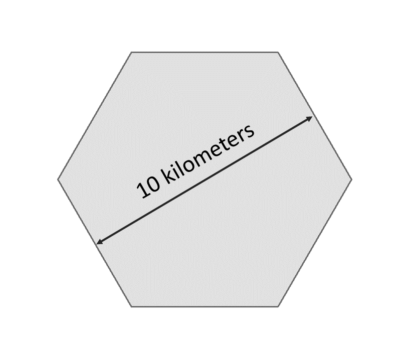
- NGS has also prioritized marks based on two spatial resolutions: 10 km and 2 km. 10 km spacing will provide good accuracy at the national scale. Users can improve local accuracy even more by collecting data at the 2 km level.
- NGS will build the transformation tool with data submitted by February 29, 2024. The tool will interpolate over areas without GPSonBM data, meaning that the transformations will be less accurate in those areas.
Priorities A and B
Priority A
Priority A marks meet the following specific criteria from their datasheets and are most likely to be used to create the transformation tools:
- Vertical Order: FIRST, SECOND
- Stability: A, B, C
- Satellite: USEABLE
- Last Recovery Condition: excluding “MARK NOT FOUND”
Priority B
Priority B marks are lower quality marks that will only be considered for use in the transformation tool to fill data gaps if no other data exists in the region.
Spatial Resolution
NGS has also prioritized marks at two spatial resolutions: 10 km and 2 km. NGS wants to reach a 10 km density to provide good national accuracy. Additionally, users can help improve local accuracy by collecting data at the 2 km level.
To prioritize marks based on the two spatial resolutions, NGS created the following system:
- A 10 kilometer hexagonal lattice was developed to define the desired data density on the ground and help select appropriate marks within those areas throughout the US and territories.
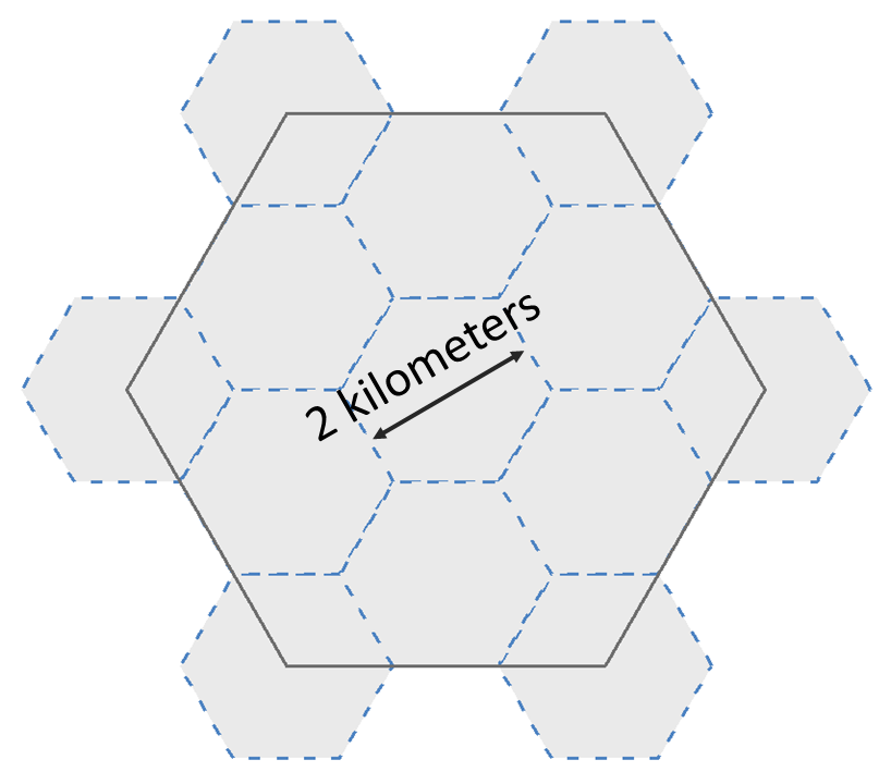
- Hexagons with appropriate bench marks were identified.
- For each hexagon, a primary mark was selected and a list of up to 4 secondary marks -- if available – were identified. The primary mark for each hexagon was added to the priority mark list. Secondary marks are listed and should be observed in cases where the primary mark cannot be found or is unobservable.
To communicate when observations in a hexagon have been completed, the following process was developed:
- Once a single mark within a 10 km hexagon has two GPS observations that meet the requirements, that hexagon is marked as done and the observed mark is removed from the prioritized list.
-
Once a 10 km hexagon is marked as done, a group of up to thirteen 2 km
hexagons is generated to define the opportunities to densify the model
with additional marks.
- In each of the 2 km hexagons, a primary mark is identified and a list of secondary marks is provided in case the primary mark cannot be found or is not observable. The new primary marks are added to the priority mark list. The number of 2 km hexagons will vary since not all areas have bench marks inside the 2 km lattice. See graphic below:
10 Kilometer Hexagon
2 Kilometer Hexagons
Defining Desired Spatial Resolution
Topography
Topography will be a major factor in deciding how dense the spatial resolution between bench marks should be. Areas that have a lot of hills or mountains would benefit from having more bench marks observed at the 2 km spacing to capture the effect of local topography. The 10 km spacing should provide adequate coverage in flat areas.
Population
Another consideration for how dense the data should be is the population in the local area. A large city with a dense population might want to collect as many marks as possible in the area since cities have a lot of infrastructure that can benefit from a more accurate transformation. On the other hand a very rural area with limited infrastructure probably does not need the same density of marks unless there is a lot of topography.
Gaps larger than 10 km (missing hexagons)
Many areas across the country do not have bench marks at the 10 km spacing, so there are many areas without any hexagons or marks. NGS will interpolate over any areas with no GPS on bench marks. Due to the method of interpolation, the larger the distance between the GPSonBM data used in the transformation, the larger the uncertainty of the transformation.
Multiple observations within 2 km
The grids used to create the transformation tools will have a spatial resolution of 2 km. This is denser than the 10 km spacing because in areas where the terrain is not flat, higher density local data can capture the geographical nuances and improve the accuracy of the transformation. Any GPS on bench mark data that a user submits will be evaluated for inclusion in the transformation model. For areas with very dense GPSonBM data, a filter will be applied to all observations falling within each 2 km grid cell, and a median value will be used.
Background
Currently there are over 400,000 bench marks across the Conterminous United States (CONUS), Alaska, Hawaii and U.S. territories. Tidal marks and bench marks are used for determining heights and when possible providing GPS on these marks can help to relate the GPS derived ellipsoid height with the leveling derived orthometric height associated with these marks.
In 2022 NGS will be modernizing the National Spatial Reference System (NSRS) and transitioning to new Reference Frames [CATRF2022, MATRF2022, NATRF2022, PATRF2022] replacing NAD 83 as well as transitioning to the Geopotential Datum (NAPGD2022) which will replace the current Vertical Datums [NAVD 88, ASVD02, PRVD02, NMVD03, GUVD04, VIVD09] for all United States and Territories. When the NSRS modernization occurs, NGS will provide a transformation tool to allow users to convert heights from these current vertical datums into the new geopotential datum.
To develop this transformation tool NGS will use GPS on bench marks (GPSonBM) with heights in the current vertical datums. The transformation tool will be based on a grid developed using all of the data available from GPS on bench marks at the time of development. NGS has developed a list of bench marks that provide the ideal spatial resolution for this transformation grid. Extensive analysis was performed on all bench marks currently in the NGS database to identify those most likely to benefit the transformation. To provide the best transformation from the current vertical datums, NGS is requesting two independent observations on each bench mark with one of the observations occurring within the last 5 years.
- Email us
-

Subscribe for GPS on Bench Mark Updates

