GEOID18 Technical Details
In June 2020, NGS released NOAA Technical Report NOS NGS 72 - GEOID18, a comprehensive explanation of the data and methods used to create GEOID18. In addition, the GEOID18 Exploratory Web Map, now allows users to visualize and analyze the GPS on Bench Marks dataset at the heart of the model.
The GEOID18 grid files posted prior to Nov 26, 2019 were created and tested in the big endian format. The grids were then converted into little endian and ASCII formats. Unfortunately, a suspected compile option error in the file format conversion software introduced errors into a random set of grid cells within the little endian and ASCII grids. These errors range from 1.9 mm to 6.25 cm and are inconsistently distributed throughout the grids.
To help avoid these types of issues in the future, NGS is working to adopt a single grid file format sometime in 2020.
The National Geodetic Survey (NGS) has produced hybrid geoids to convert ellipsoid heights obtained from Global Navigation Satellite Systems (GNSS) to orthometric heights within a specific vertical datum. GEOID18 is the latest hybrid geoid model to be used for the following vertical datums within the United States and its territories: the North American Vertical Datum of 1988 (NAVD 88) for the conterminous United States, the Puerto Rico Vertical Datum of 2002 (PRVD02), and the Virgin Islands Vertical Datum of 2009 (VIVD09). GEOID18 represents the zero height surface for these datums and should be used exclusively with NAD 83 (2011) epoch 2010.0 ellipsoid heights. Ellipsoid heights with respect to other realizations of NAD 83, WGS 84, ITRF, and any other reference frames are not compatible with GEOID18. Previous versions of NAD 83 can be converted to NAD 83 (2011) using the NGS Coordinate Conversion and Transformation Tool (NCAT). WGS 84, ITRF, and other global frames can be converted to NAD 83 using the NGS’s Horizontal Time-Dependent Positioning (HTDP) program. However, these tools always introduce error into the transformed coordinates, and so they should be used with caution.
GEOID18 was created in a two step process. In the first step, a purely gravimetric geoid is needed for the United States and its territories. For GEOID18, the xGEOID19B gravimetric geoid model is used as this basis. xGEOID19B is based on a 1′ × 1′ gravity grid derived from the NGS surface gravity data and the altimetry-derived anomalies, airborne gravity from the Gravity for the Redefinition of the American Vertical Datum (GRAV-D), the SRTM 3" DEM for its topographic reductions, and global satellite gravity models. For more information about xGEOID19B, visit the xGEOID19 Web Site. In the second (hybridization) step, the gravimetric geoid model is warped to fit the existing GPS on bench mark data using least squares collocation (Moritz, 1980).
This two step process is done completely and independently for each of the two regions contained within GEOID18: CONUS and Puerto Rico/U.S. Virgin Islands.
GPS on Bench Marks for GEOID18: Data
For GEOID18, a total of 32,357 bench marks are used in the modeling in CONUS and 127 bench marks are used in Puerto Rico and the US Virgin Islands. A great deal of work was undertaken by NGS to arrive at the above mentioned list of high-quality bench marks. Approximately 4,224 bench marks in CONUS are not used in the geoid model construction as these were deemed to be outliers or are derived from single GPS occupations. In Puerto Rico and the US Virgin Islands, there were 18 total outliers or single GPS occupations that were not used.
GPS on Bench Marks for GEOID18: Analysis
From the GPS on bench marks, the hybrid geoid uses a residual as defined by the following equation, which was computed at every bench mark:
r = hNAD 83(2011) - HNAVD 88 - NxGEOID19B
(Equation 1)
hNAD 83(2011) is the GPS derived ellipsoid height with respect to NAD83(2011).
HNAVD 88 is the orthometric height derived from leveling with respect to NAVD 88.
(In Puerto Rico and U.S. Virgin Islands, this is with respect to PRVD02 and VIVD09, respectively)
NxGEOID19B is the gravimetric geoid height
The GPS on bench mark dataset was meticulously evaluated mark-by-mark to identify outliers and marks with suspect elevation information. This procedure involved the following investigation and analysis:
- Compute and plot geoid model values minus GPS/Leveling derived values (residuals from equation 1, with bias and tilt removed)
-
Identify and reject large relative differences in residuals between
closely spaced bench marks
- Differences greater than 2 cm for stations less than 5 km apart
- Differences greater than 3 cm for stations less than 10 km apart
- Differences greater than 5 cm for stations less than 50 km apart
Specific attributes of the bench marks were also considered when rejecting a GPS on bench mark which included information regarding the leveled orthometric height and the GPS ellipsoid height.
Attributes of the leveling heights considered include (1) age of the leveling line used to establish the NAVD 88 height, (2) “New minus Old” values in areas where there was enough repeat leveling to estimate movement of bench marks, (3) bench mark heights based on leveling spurs, and (4) NGSIDB datasheet indicates that the bench mark’s NAVD 88 height value was not rigorously determined.
Attributes of the GPS ellipsoid heights include (1) station’s local and network accuracy value, (2) station’s involvement in the NA2011 Network adjustment as primary (mainly marks last occupied during or after 1994) or secondary (mainly marks last occupied before 1994), (3) network design used to establish the GPS-derived ellipsoid height, and (4) GPS network design where there wasn’t a direct connection between closely spaced stations that have large relative differences in outliers, and (5) marks that were determined from only a single GPS vector (“no check” marks).
GPS on Bench Marks for GEOID18: Gulf Coast Region
There are areas of complex vertical crustal motion in the Texas/Louisiana Gulf Coast region of the United States which render many control station elevations in the region invalid. The selection of GPS on Bench Marks in this region was limited to the small number of marks where the leveling and GPS data agreed to minimize the influence of crustal motion in the hybrid geoid model. Figure 1 depicts the selection of stations used in the hybrid geoid model along the Texas/Louisiana Gulf Coast.
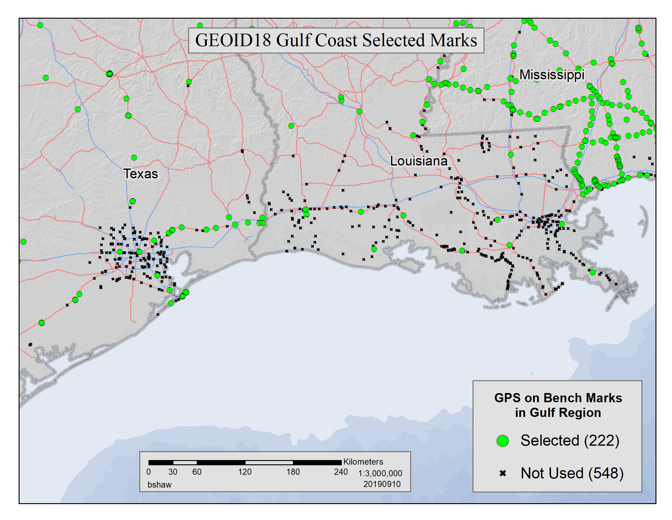
Figure 1: GEOID18 Gulf Coast selected marks
(Click image for higher resolution)
Hybrid Geoid Model Construction
The residuals obtained in equation 1 are contaminated with a continential tilt and bias that is estimated and removed with a simple two-dimensional planar surface. The bias-free and tilt-free residuals are ultimately used to determine a mathematical model using least squares collocation (LSC) and multiple Gaussian functions to describe the behavior seen at the bench marks. Once the relationship between the points is modeled, the model is used to generate a 1 arcminute regular grid for interpolation purposes. Figure 2 shows the final conversion surface. This surface represents the difference between NAVD 88 as a datum and the geopotential (geoid) surface used in the gravimetric geoid. This is the difference between the hybrid geoid and the gravimetric geoid with respect to NAD83 (GEOID18 - xGEOID19B). This surface has three essential components: a bias, a continental tilt, and local warping from the bench marks.
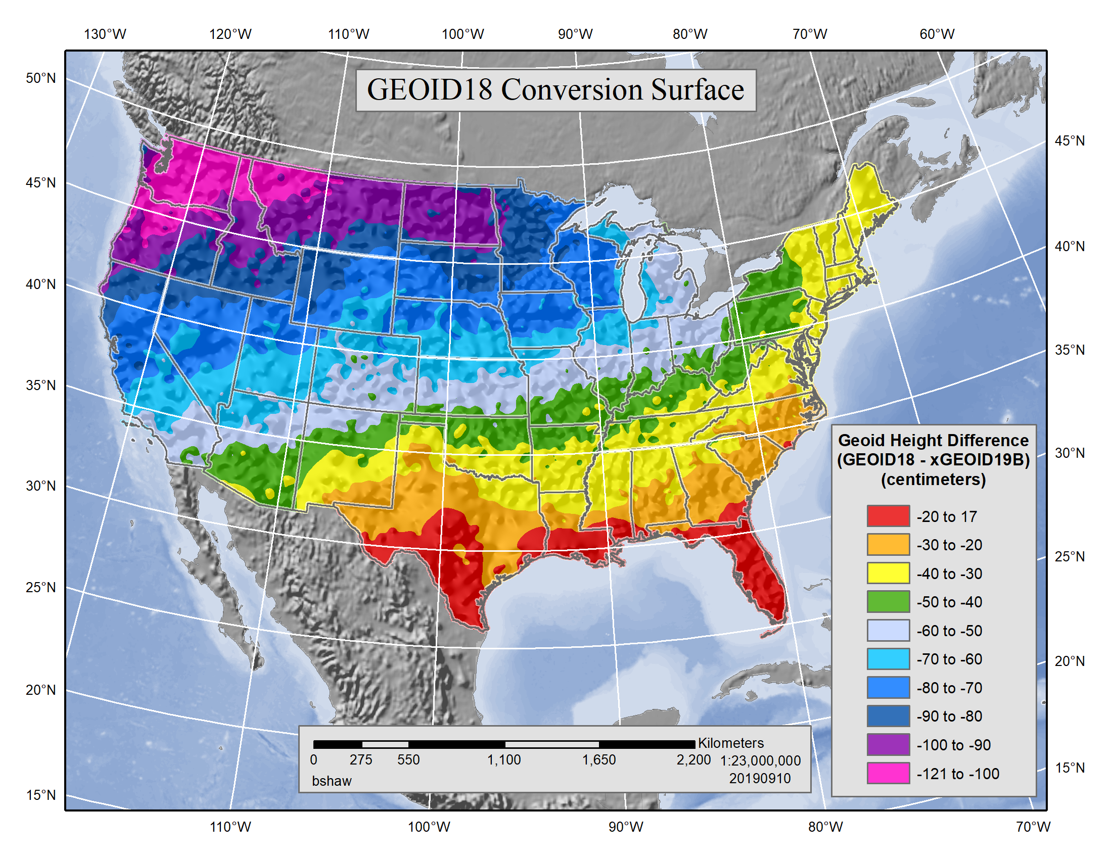
Figure 2: GEOID18 Conversion Surface in cm.
(Click image for higher resolution)
The overall fit of the final GEOID18 model to used bench marks is excellent. Over all of CONUS, the standard deviation is 1.27 cm (GEOID12B was approximately 1.7 cm). The overall statistics for CONUS and PRVI are shown in Table 1.
CONUS, Canda,
and Mexico
CONUS Only
Puerto Rico and
US Virgin Islands
Table 1: GPS on Bench Marks Residuals to GEOID18 - indicates how well, on average, the bench marks used fit the model and can be considered a metric of the overall quality of the model.
GEOID18 Estimated Uncertainty
The purpose of GEOID18 is to return a geoid height that is consistent with the published NAVD 88 orthometric heights on NGS Data Sheets when used with GPS-derived NAD 83 (2011) epoch 2010.0 ellipsoid heights. NGS has chosen to use the term estimated uncertainties which is intended to refer to how well the GEOID18 model performs this task. Estimated uncertainties are computed and stored in the grids as 1-sigma (68%) values for the geoid height (i.e. σN) but NGS tools provide 95% (1.96 * σN) confidence values. The reported estimated uncertainties do NOT include errors inherent in NAVD 88 itself or the underlying gravimetric geoid model xGEOID19B. That is, the estimated uncertainty is of the fit of the GEOID18 surface to the NAVD 88 datum “surface” implied by the bench marks used to create GEOID18. As such, it is useful for estimating the local relative accuracy of the GEOID18 model, but not its overall accuracy. The estimated uncertainty files for GEOID18 cover the same regions as the geoid model: CONUS and Puerto Rico and the U.S. Virgin Islands. This uncertainty is based on the least squares collocation propagated error estimates associated with the bench marks used. Due to the nature of the mathematical error propagation methods used, the uncertainty estimates provided in areas with dense bench mark coverage may be overly optimistic, while the values provided in areas with very sparse bench marks coverage may be somewhat pessimistic. The estimated uncertainty is mostly driven by the distance to a bench mark used to determine GEOID18. Because of this variability, the estimated uncertainties should be used with caution, and they should not be considered a substitute for the proper surveying practice of always observing at least two valid NAVD 88 bench marks (or more if results are inconsistent).
Quantifying how well the GEOID18 model performs is a complicated process to compute and to describe. Many words can be used, such as Error / Accuracy / Uncertainty / Misfit, and each have specific and nuanced meanings that vary among the variety of scientific and mathematical disciplines. To obtain estimated uncertainties of GPS-derived NAVD 88 orthometric heights, the user should consider both the geoid estimated uncertainty and the ellipsoid height uncertainty (σh).
Other available models and related products:
Gravimetric Geoid Models
Currently, NGS produces an experimental gravimetric geoid model on an annual basis. This series of models is called the xGEOID models. These cover a region from 0°N to 90°N and 170°E to 350°E and include the entire United States and its territories. For more information, see: xGeoid Web Site
The last official gravimetric model, USGG2012, was released in 2012 in conjunction with GEOID12.
For global needs, the National Geospatial-Intelligence Agency (NGA) produces EGM2008 and the soon to be released EGM2020.
Other Hybrid Geoid Models
The GEOID12B model continues to be the official hybrid geoid model for use in Alaska, Hawaii, Guam and Northern Mariana Islands. There are a number of superseded hybrid geoid models available on the Geoid Web Site. The GEOID12B model for American Samoa should not be used because the American Samoa Vertical Datum of 2002 (ASVD02) has been deprecated due to major earthquakes.
Deflections of the Vertical (DoV)
Deflections of the vertical (DoV) can be computed from either the gravimetric or the hybrid geoid models. The DoV computed from hybrid GEOID18 is designated as DEFLEC18 and is with respect to NAD 83 (2011) epoch 2010.0. The most recent version associated with the gravimetric xGEOID model is xDEFLEC19 and is with respect to the IGS08 reference frame at epoch 2005.0.
Summary and Recommendations
GEOID18 is a significantly different and improved hybrid geoid model compared with previous NGS hybrid geoid models. This is due to a number of reasons including an entirely new gravimetric geoid model in xGEOID19B with GRAV-D data, new elevation models, new and improved gravity coverage, and better modeling theory. However, the most significant improvement is the additional GPS on bench marks collected in the past few years by the surveying and geodetic community. These new observations have provided better spatial coverage in the model and allowed NGS to perform a more thorough point-by-point analysis of the data, removal of outliers, and use of more up-to-date ellipsoid heights. The relative accuracy of GEOID18 to NAVD 88 is characterized by a estimated uncertainty of +/-1.27 centimeters nationwide.
Data in the NGS Integrated Database (IDB) are constantly updated, hence older hybrid geoid models are not consistent with newer ellipsoid and orthometric heights present in the IDB today. To obtain the most consistency between GPS derived ellipsoid heights and NAVD 88, the latest hybrid geoid model valid for that region should be used, either GEOID18 or GEOID12B.
While GEOID18 extends into Canada, Mexico, Bermuda, the Bahamas, and into large
water bodies like the Great Lakes and ocean, this model has no real value in
those places and should not be used in those areas. The reason for this is
that significant extrapolation errors are definitely present and expected in
areas where there are no GPS on bench mark data to constrain the model.
References:
Moritiz, H. (1980). Advanced Physical Geodesy.

