GPS on Bench Marks Campaign
NGS encourages anyone with survey-grade Global Positioning System (GPS) receivers to help improve the National Spatial Reference System (NSRS) by collecting GPS observations at geodetic bench marks.
Why?
The nation’s height system, the North American Datum of 1988 (NAVD88), is founded on historic geodetic leveling surveys on thousands of bench marks that are often difficult and expensive to access. By adding GPS coordinates to these marks, the height system can be modeled in GPS survey systems for easier access. The latest hybrid geoid model, GEOID12A , includes many “GPS on bench mark” observations, but would benefit from additional data collection in many areas
When?
GPS information can be submitted to NGS at any time. GPS observations shared after the release of GEOID12A and before the next hybrid geoid model will help improve the vertical reference system.
Many individuals participated in the the 2014 GPS on Bench Marks Campaign, a National Surveyors Week (March 16-22) event to raise awareness about professional surveying while improving the National Spatial Reference System (NSRS). NGS expects that similar efforts will be organized in the future, and you can read more about the 2014 Campaign online.
How?
- Find local bench marks using the maps and lists below, which prioritize NAVD 88 bench marks based on GEOID12A estimated accuracy, vertical order, stability, and distance from road. For Alaska and Hawaii, GPS on any tidal or leveled bench mark is appreciated. Additionally, you can use the NGS Data Explorer or DSWorld to identify bench marks near you.
- Collect GPS on your selected bench mark following careful field procedures. You should:
- Complete reconnaissance at your selected mark to ensure usability and identify alternative marks (time-permitting).
- Collect a 4+ hour GPS data file.
- Verify antenna type, height, and plumb.
- Use a fixed height tripod (recommended), and brace the legs with sandbags or chain.
- Take two photos of the mark, and note any changes to the existing mark description. (Optional: use observer field log with this step.)
- Share your data by uploading to OPUS using option 'share my solution.'
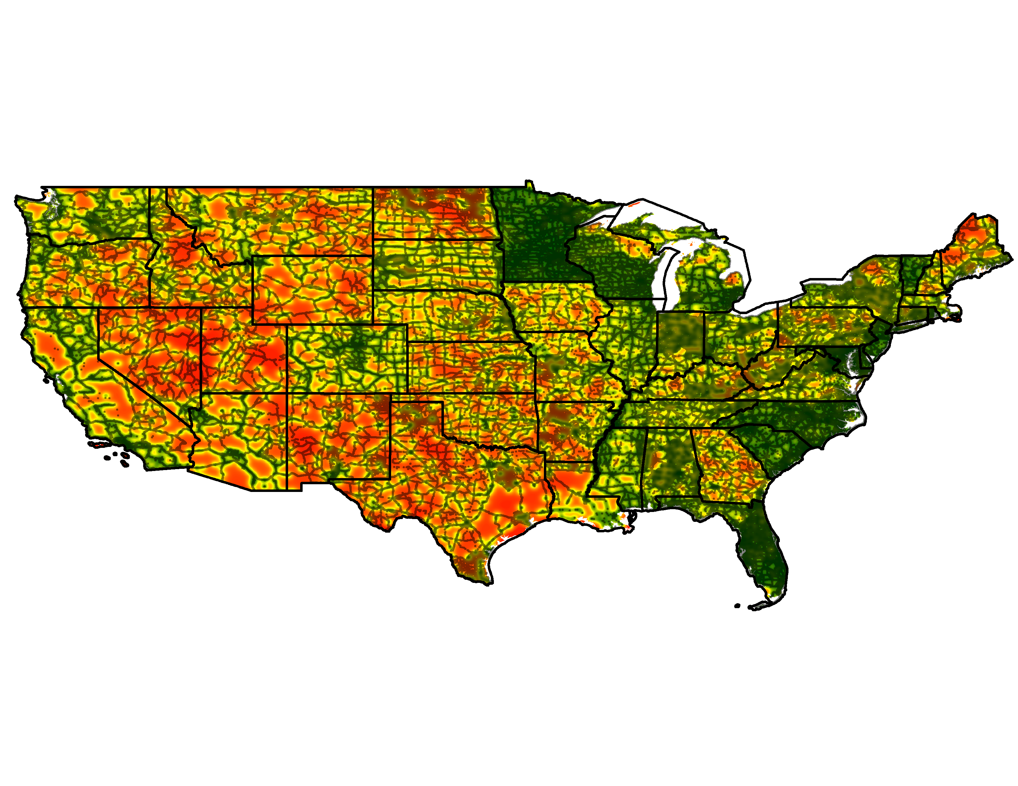
Prioritized bench marks and GEOID12A estimated accuracy map

Click on the map above or use the links below to view state-specific maps that prioritize existing bench marks for GPS observation. Lists of prioritized bench marks for each state are also available below, ordered by county. Information about Alaska, Hawaii, Puerto Rico, the U.S. Virgin Islands and other territories is still being developed. (Map created by NOAA’s National Geodetic Survey, Feb. 2014; high resolution available.)
Download state-specific maps and priority bench mark lists, which are ordered by county. Information about Alaska, Hawaii, Puerto Rico, the U.S. Virgin Islands and other territories is still being developed.
| All CONUS (maps/lists) | Maine (map / list) | Ohio (map / list) |
| Alabama (map / list) | Maryland (map / list) | Oklahoma (map / list) |
| Arizona (map / list) | Massachusetts (map / list) | Oregon (map / list) |
| Arkansas (map / list) | Michigan (map / list) | Pennsylvania (map / list) |
| California (map / list) | Minnesota (map / list) | Rhode Island (map / list) |
| Colorado (map / list) | Mississippi (map / list) | South Carolina (map / list) |
| Connecticut (map / list) | Missouri (map / list) | South Dakota (map / list) |
| Delaware (map / list) | Montana (map / list) | Tennessee (map / list) |
| Florida (map / list) | Nebraska (map / list) | Texas (map / list) |
| Georgia (map / list) | Nevada (map / list) | Utah (map / list) |
| Idaho (map / list) | New Hampshire (map / list) | Vermont (map / list) |
| Illinois (map / list) | New Jersey (map / list) | Virginia (map / list) |
| Indiana (map / list) | New Mexico (map / list) | Washington (map / list) |
| Iowa (map / list) | New York (map / list) | West Virginia (map / list) |
| Kansas (map / list) | North Carolina (map / list) | Wisconsin (map / list) |
| Kentucky (map / list) | North Dakota (map / list) | Wyoming (map / list) |
| Louisiana (map / list) |
What happens next?
NGS will use your data to improve the next hybrid geoid model, increasing access to NAVD 88, and enabling conversions to the new vertical datum in 2022. Make sure you contact a geodetic advisor or your local professional land surveyor’s organization to see if there are any local coordination efforts planned. If you still have questions, email us.
Additional resources:
- DSWorld is available online, and when it is open click menu item “Plot >GEOID12A accuracy”
- Download GPS on bench marks used in the most recent hybrid geoid model from the GEOID12A web page.
- View other OPUS shared solutions to see what marks have already been observed since GEOID12A.

