National Geodetic Survey: Student Opportunities
The Pathways Program
Overview
NOAA's National Geodetic Survey, Center for Operational Oceanographic Products and Services (CO-OPS), and Office of Coast Survey (OCS) are offering students and recent graduates paid opportunities to explore Federal careers while still in school. NGS, CO-OPS, and OCS provide unique but related data and products to assist with coastal mapping, understanding water levels, and providing the foundational geospatial infrastructure for a wide variety of activities. These agencies draw from a talent pool that is extremely diverse, with needs for oceanographers, data scientists, engineers, GIS specialists, geodesists, land surveyors, programmers, and remote sensing specialists.
Program Details
Students or recent graduates selected for the Pathways Program will perform on-the-job training assignments as a student trainee in the Pathways Program. This Program is designed to provide opportunities to work in agencies and explore Federal careers while still in school and while getting paid for the work performed.
- Students currently enrolled in an accredited high school, college (including 4-year colleges/universities, community colleges, and junior colleges); professional, technical, vocational, and trade school; advanced degree programs; or other qualifying educational institution pursuing a qualifying degree or certificate, are eligible to apply. Students who successfully complete the program may be eligible for conversion to a permanent job in the civil service.
- Incumbent would generally work 40 hours a week during the summer months and potentially over other school breaks.
- Candidates would begin this program as a ZP-1, salary range between $24,766 ($12/hour) and $55,300 ($26/hour). Placement within the salary range will depend on the candidate's experience level. If the student converts to a permanent position with the federal government, there is a possibility of moving into higher salary bands.
Example Job Duties
Student interns will learn about and work on a wide variety of projects for all three agencies, rotating through tasks over the course of roughly three summers. The initial experience for the student will be focused on foundational positioning topics and projects, expanding in scope and difficulty throughout the program, with input from the student throughout their education. Ultimately, the design of this program will be to align the conversion to a full-time position with the interests and talents of the student. Potential paths of learning could roughly follow the below schedule.
Some examples may include: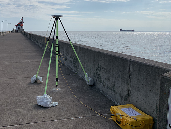
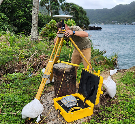
- Spatial reference systems, data, and observation equipment.
- Collect and process geodetic survey data acquired from Global Navigation Satellite System (GNSS) equipment, differential leveling, and/or gravity meters.
- Assist in the installation and maintenance of Continuously Operating Reference Stations (CORS) and Foundation CORS (FCORS).
- Monitoring land movement around water level stations, supporting the measurement of water level changes and subsidence.
- Assist with the installation of CO-OPS water levels, while learning about the science behind them.
- Create or update GIS maps in support of inundation mapping.
- Collect bathymetric data or other remotely sensed data.
Future topics that could be explored based on career path:
- Support the development of new technologies to capture data (autonomous, uncrewed systems).
- Utilize machine learning to enable increased efficiencies in data processing and product creation.
- Work with Cybersecurity and IT systems management.
