VERTCON 3.0
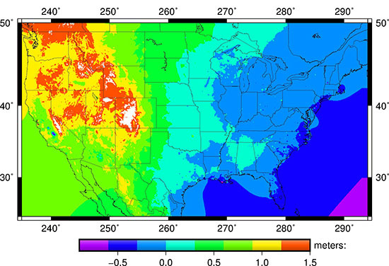
VERTCON 3.0 height shifts between NGVD 29 and NAVD 88
What is VERTCON 3.0?
VERTCON 3.0 was a project whose intent was to create new “build software”, and use that software to build and release transformation grids capable of performing orthometric height transformations for a range of datums and regions in the National Spatial Reference System. Those new grids (and supporting information) are called VERTCON 3.0 release 20190601. The grids in VERTCON 3.0 release 20190601 are replacements for those in VERTCON 2.1, which transformed only between NGVD 29 and NAVD 88 for CONUS. However VERTCON is no longer the name of a stand-alone transformation tool. The actual transformation tool is NGS’s Coordinate Conversion and Transformation Tool (NCAT), in which VERTCON 3.0 release 20190601 is but one part. VERTCON 3.0 release 20190601 adds support for vertical datums on islands and Alaska, and the VERTCON 3.0 build software prepares NGS for the upcoming NAPGD2022 release.
How do I use VERTCON 3.0?
VERTCON 3.0 release 20190601 is functionally implemented in NGS’s Coordinate Conversion and Transformation Tool (NCAT). Unlike earlier versions of VERTCON, VERTCON 3.0 release 20190601 is not a stand-alone tool.
Visit the VERTCON 3.0 Digital Archive to access raw transformation data that make up VERTCON 3.0 release 20190601 (e.g., grids, images, software).
How can I learn more about VERTCON 3.0?
NOAA Technical Report NOS NGS 68 (PDF, 8 MB) provides detailed information on VERTCON 3.0, and the digital archive includes plots and data.

