Gravity for the Redefinition of the American Vertical
Datum (GRAV-D) Project, Airborne Gravity Data
Block CS01
Block Description:
GRAV-D Block CS01 is located in the Central Time Zone, in the South half (south of 40° latitude). This was the first (01) block of data completed in the Central South region. Block CS01 covers part of the Gulf of Mexico, from the coastal areas of the Alabama/Florida state border to ~350 km (215 miles) offshore.
Block Extent Data LinesDownload:
- Newest products for this Block (zip)
NGS released a new version, BETA #2, processed in ITRF08 on September 9th, 2014. Zip file contains: ReadMe text file, gravity data file, supplementary data file, block data user manual, xml metadata, kml block extent, and kml block data lines.
The General Airborne Gravity User Manual is available for download on the main data page. - Images of gravity data for this Block
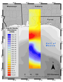
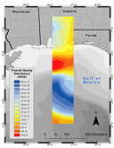
Map of Free-Air Gravity Disturbance using Equal Interval (left) and Quantile (right) classification
- Archive of all product versions for this Block
Version BETA #1, released November, 2011is available here.
How to Cite These Data:
The following citations should be used in all presentations or publications that reference the GRAV-D work. Please replace the DATE tag in the following references with the date you downloaded the data or reports from the NGS website.
To reference the CS01 data file, reference the webpage:
GRAV-D Team (2014). "Gravity for the Redefinition of the American Vertical Datum (GRAV-D) Project, Airborne Gravity Data; Block CS01". Available DATE. Online at: http://www.ngs.noaa.gov/GRAV-D/data_cs01.shtml
To reference the block and survey details, reference the block user manual:
GRAV-D Team (2014). "Block CS01 (Central South 01); GRAV-D Airborne Gravity Data User Manual." Theresa Damiani, ed. Version 1. Available DATE. Online at: http://www.ngs.noaa.gov/GRAV-D/data_cs01.shtml
To reference the general GRAV-D project operations, reference the General User Manual:
GRAV-D Team (2014). "GRAV-D General Airborne Gravity Data User Manual." Theresa Damiani, ed. Version 1. Available DATE. Online at: http://www.ngs.noaa.gov/GRAV-D/data_cs01.shtml