- Lt. Col. Thomas Lincoln Casey, 1885
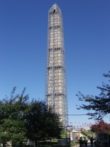
Although NGS—formerly the U.S. Coast and Geodetic Survey (USC&GS)— surveyed points at the base of the WM many times in the building’s 120-plus year history, only twice before (in 1934 and 1999) had full scaffolding allowed surveyors access to the peak of the structure. The 1934 and 1999 surveys were of insufficient accuracy to detect whether any subtle changes had taken place in the peak’s three-dimensional location in space.
The new scaffolding provided NGS the opportunity to once again collaborate with the National Park Service (NPS) to survey the peak of the WM, this time with greater accuracy than previously achieved. NGS’ primary goal for the new endeavor was to position the peak within the National Spatial Reference System (NSRS) and, as a secondary goal, to provide a building height measured to an international standard.
In 1885, Lt. Col. Thomas Lincoln Casey reported the height of the WM as "555 feet, 5 1/8 inches." Modern attempts to validate the 1885 measurement have been difficult, because the "architectural zero height point" (AZHP) location—the actual starting point for that measurement—is currently unknown.
In 2013, with the goal of positioning the peak of the WM (latitude, longitude and elevation), and as a separate product of that survey, calculating the architectural height of the building (a "base-to-tip" height) using modern technology and international standards, NGS approached NPS to request a collaborative effort between the two agencies. While the accurate surveying, measuring, and positioning of points in space is NGS’ specialty, the use of those measurements to define the architectural height of a building falls under the mission of the Council on Tall Buildings and Urban Habitat (CTBUH), the body formed in 1969 as the “the arbiter of the criteria upon which tall building height is measured.”