| June 28 2025 |
|
||
|
 |
|
The United States has approximately 95,000
miles of coastline (as compiled from 1:80,000-scale charts). One of the missions of NOAA's National Geodetic Survey (NGS) is to survey
these coastal regions and to provide the Nation with accurate, consistent, up-to-date national
shoreline.
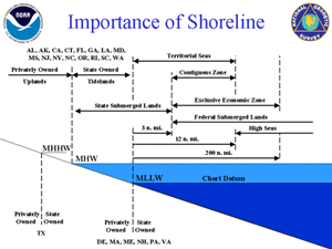
At present, several different shoreline definitions are in use by various Federal, state, and local authorities. The use of inconsistent shoreline definitions between maps, charts, Geographic Information Systems (GIS), and other products can lead to confusion by users and can contribute to ill-informed decision making. Broader adoption of the NOAA-provided national shoreline is encouraged to help alleviate this problem. The method used today by NGS to delineate the shoreline is stereo photogrammetry using tide-coordinated aerial photography controlled by kinematic Global Positioning System (GPS) techniques. This process produces a seamless, digital database of the national shoreline and a database of aerial photography. NGS is exploring the use of new technologies and new methodologies to map the shoreline including: Interferometric
Synthetic Aperture Radar (SAR)
For additional information on shoreline,
also visit the NOAA
Coastal Shoreline Website.
|
|
National Oceanic and Atmospheric
Administration/
National Ocean Service/ National Geodetic Survey Last modified: May 16 2017 |
|