| June 21 2025 |
|
||
|
 |
|
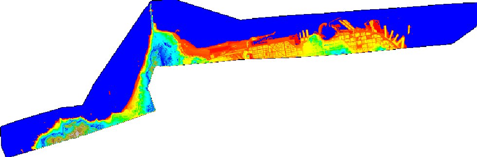
Recent advancements in remote sensing technologies have introduced new and efficient methods to acquire information about the earth. One such technology currently being investigated by the NGS Remote Sensing Research and Development Team is Light Detection and Ranging (LIDAR). LIDAR is an active remote sensing system that can be operated in either a profiling or scanning mode using pulses of light to illuminate the terrain. LIDAR data collection involves mounting an airborne laser scanning system onboard an aircraft along with a kinematic Global Positioning System (GPS) receiver to locate an x, y, z position and an inertial navigation system to monitor the pitch, roll, and heading of the aircraft. By accurately measuring the round trip travel time of the laser pulse from the aircraft to the ground, a highly accurate spot elevation can be calculated. Depending upon the altitude and speed of the aircraft along with the laser repetition rate it is possible to obtain point densities that would likely take months to collect using traditional ground survey methods. LIDAR has been tested in a wide variety of applications including assessing post storm damage to beaches, mapping the Greenland ice sheet, and measuring heights within forest timber stands. NGS is examining the possibility of implementing LIDAR into the production of shoreline manuscripts and airspace obstruction charts. LIDAR is also playing a role in recent research into automated shoreline definition by using the VDatum tool to derive a mathematical shoreline from the LIDAR point data. The image below is a pseudo-color ramp on a DEM from LIDAR data collected in San Francisco. These data were collected in September 2002 using an Optech 1233 ALTM LIDAR system aboard the NOAA Cessna Citation aircraft. The Golden Gate bridge is the peak protruding at the top left of the image, while the Fisherman's Wharf and downtown commercial district along the bay are at the right in the image.
See more information about the San Francisco LIDAR experiments. |
|
National Oceanic and Atmospheric
Administration/
National Ocean Service/ National Geodetic Survey Last modified: May 16 2017 |
|