Most of the discussion to this point has been concerned with geometrical geodesy. This aspect of the science is involved with strictly geometrical relationships measured in various ways-triangulation, trilateration, electronic surveys, etc.-for the purpose of deducing the size and shape of the earth and the precise location of specific positions on the earth's surface. Geometric geodesy considers the geoid through the use of astrogeodetic methods. For example, the astro-geodetic orientation method was discussed in the previous chapter.
This chapter introduces another branch of geodetic science known as physical geodesy. Physical geodesy utilizes measurements and characteristics of the earth's gravity field as well as theories regarding this field to deduce the shape of the geoid and in combination with arc measurements, the earth's size. With sufficient information regarding the earth's gravity field, it is possible to determine geoid undulations, gravimetric deflections, and the earth's flattening.
In using the earth's gravity field to determine the shape of the geoid, the acceleration of gravity is measured at or near the surface of the earth. It might be interesting to compare the acceleration measured by the gravimetrist and the acceleration experienced in an airplane. In an airplane, an acceleration is simply called a G force and is measured by a G meter. A G factor of one is used to indicate the acceleration due to the attraction of the earth and is considered a neutral condition. The gravity unit used and measured in geodesy is much smaller. A G factor of one is approximately equal to one thousand gals, a unit named after Galileo. The still smaller unit used in geodesy is the milligal (mgal) or one-thousandth part of a gal. Thus, in geodesy we are dealing with variations in acceleration equal to one millionth of a one G aircraft acceleration. The most accurate modern instruments permit measurement of acceleration changes of one hundred millionth part of the well known G factor or better.
Gravity Measurements
An attracting force, called gravitational force, operates between the earth and every object that is located within, on, or above the earth's surface. At the same time, any object within or on the earth's surface pursues a circular path as the earth rotates on its axis. If the body is on the earth's surface, it follows the circular path because it is held onto the earth's surface by the gravitational force. However, the body as it pursues a circular path exerts an outward force called the centrifugal reaction. The centrifugal reaction can be experienced by revolving an object at the end of a string. The sum of the gravitational force and centrifugal reaction acting on a body is called gravity. Since the gravitational force is much stronger than the centrifugal reaction, gravity causes an object to have weight and, if the object is free to move, to fall with increasing speed (i.e., the body accelerates) toward the center of the earth. The acceleration experienced by that object as it moves toward the earth's center is called the acceleration of gravity, which is the quantity observed when gravity measurements are made.
Two distinctly different types of gravity measurements are made: absolute gravity measurements and relative gravity measurements. If the value of acceleration of gravity can be determined at the point of measurement directly from the data observed at that point, the gravity measurement is absolute. If only the differences in the value of the acceleration of gravity are measured between two or more points, the measurements are relative.
Absolute measurement of gravity-Until the middle of the 20th Century, virtually all absolute measurements of gravity were made using some type of pendulum apparatus. The most usual type of apparatus contained a number of pendulums that were swung in a vacuum. By measuring the peroid of the pendulums, the acceleration of gravity could be computed. In 1818, Kater developed the so-called reversible pendulum that had knife edge pivots at both ends. These pendulums were flipped over (reversed) during the measurements and, using this procedure, a number of important error sources were eliminated. Still, there were numerous other problems and error sources associated with pendulum measurements of absolute gravity, and the results obtained were not sufficiently accurate to meet the needs of geodetic gravimetry. Consequently, in recent years, the pendulum method has been superseded by the ballistic method which is based on timing freely falling bodies. The acceleration of gravity can be determined by measuring the time taken by a body to fall over a known distance.
In the United States, the basic falling body apparatus was developed in the early 1970's jointly by J.A. Hammond of the Air Force Geophysics Laboratory and J.E. Faller of the Joint Institute for Laboratory Astrophysics. In the so-called Hammond-Faller apparatus, a corner cube reflector falls in a vacuum while distance and time are measured continuously by a laser beam in conjunction with a photo multiplier tube. This apparatus weighed about 800 kilograms and considerably more accurate than the best absolute pendulum apparatus. Hammond recently has completed fabrication of a somewhat smaller and more accurate version of the original Hammond-Faller apparatus. The new instrument weighs about 700 kilograms when packed for shipment in nine units. Hammond's apparatus has been used to establish very accurate values for absolute gravity at a number of sites within the United States. Faller is also developing a more refined falling body apparatus. The most elaborate and probably the most accurate ballistic apparatus has been developed by Sakuma. The equipment occupies two rooms at the International Bureau of Weights and Measures at Sevres, France, and unlike the other instruments described here, is not portable. Sakuma's apparatus is a rising and falling body apparatus. A body is projected upward and allowed to rise and fall in a partial vacuum. Measurements of time and distance are made during both the rise and fall. Certain error sources cancel out when such a procedure is used. An Italian group, Instituto di Metrologia "G. Colonetti" has worked with Sakuma to develop a miniaturized, portable version of Sakuma's apparatus. This portable version, generally known as "the Italian Apparatus," has been used to make very accurate measurements of absolute gravity at a number of sites in Europe and the United States since 1976. A French group, in 1977, advertised its plans to manufacture a version of the Italian apparatus for sale.
Over the years, absolute gravity measurements have been made at only a few key sites, and these few measurements have served chiefly to establish datum and scale for relative gravity measurements. The reasons for the sparsity of absolute gravity measurements is that the necessary measuring equipment is very bulky and costly, and a single measurement requires days of painstakingly careful work under near laboratory conditions. This, however, may change in the next decade or so. As absolute equipment continues to be miniaturized and made more portable, absolute gravity measurements are becoming more commonplace.
Relative measurement of gravity-Solution of some of the problems of gravimetric geodesy requires a knowledge of the acceleration of gravity at very many points distributed uniformly over the entire surface of the earth. Since absolute gravity measurements have been too complicated and time consuming and, until recently, could not be obtained with sufficient accuracy, relative gravity measurements have been used to establish the dense network of gravity measurements needed. The earliest relative gravity measurements were made with reversible pendulums. Since the theory of relative pendulum measurements is somewhat simpler than that of absolute pendulum measurements, better accuracy was obtained for the former. However, the equipment was bulky, measurements were time consuming, and better accuracy was desired than could be obtained with pendulums. The most accurate relative pendulums to be developed were the Gulf quartz pendulum and the Cambridge invar pendulum. These two instruments were used as late as 1969.
Modern relative gravity measurements are made with small, very portable, and easily used instruments known as gravimeters (gravity meters). Using gravimeters, highly accurate relative measurements can be made at a given site, known as a gravity station, in half-an-hour or less. Modern gravimeter-type instuments were first developed in the 1930's. Although at least 28 different kinds of gravimeters have been developed, only two types have been used extensively. The LaCoste-Romberg gravimeters are used for most geodetic work today, although the Worden gravimeters have been used extensively for such work in the past.
The heart of all modern gravimeters consists of a weight suspended by a very sensitive spring. Changes in length of the spring due to changes in the acceleration of gravity as the gravimeter is moved from place to place are translated by the mechanisms of the gravimeter into "dial reading" differences which are proportional to gravity differences. The relative measurements at each gravity station consists of reading the gravimeter dial when the spring has been adjusted to a null or equilibrium position. The constant of proportionality relating dial reading differences to gravity difference is known as the calibration constant or calibration factor. The dial reading of the gravimeter at each site is multiplied by the calibration factor to obtain a gravity value. Each instrument has a unique calibration factor which must be determined empirically. This is done by the manufacturer. Many gravimeter users redetermine and periodically check the calibration factor by taking dial readings over a so-called calibration line. A calibration line is a series of well described monumented, reoccupied sites where the acceleration of gravity has been determined very accurately and over which the value of gravity varies significantly. By comparing the dial readings to the known gravity values at points along the calibration line, the calibration factor can be computed. In this manner, the scale of relative gravity surveys is controlled by the calibration factor. For the most precise work, it cannot be assumed that the calibration factor is constant, and more complicated calibration procedures must be used.
There are two other important considerations when relative gravity measurements are made: drift and base station connections. Gravimeter drift is a phenomenon related to certain instrumental instabilities that cause the dial reading to change slowly with time even when the accelration of gravity remains constant. Although the amount of drift is very small for most modern gravimeters, it still must be determined and eliminated from the relative gravity measurements. There are several observational techniques commonly used, but all involve some kind of looping back to previously measured points such that the relative gravity survey is continuously closed back on itself. The difference in dial readings (converted to gravity) between two successive occupations of the same site is the drift of the gravimeter over the interval of time which has elapsed between the two occupations. Drift is often considered to occur at a constant rate. Consequently, the time at which each measurement is made is recorded along with the dial reading. After each closure in the survey, the total drift is determined and allocated back through the loop proportionally to the time elapsed between each measurement. For the most accurate work, drift cannot be assumed to be constant, and more complicated techniques should be employed. For the most accurate gravity surveys, several gravimeters are used simultaneously, and a least squares adjustment is applied to compensate for imprecise drift and calibration determinations.
Since relative gravity surveys can determine only differences in gravity from point to point, every relative gravity survey must include measurements at one or more reoccupiable points where acceleration of gravity is known. Such points are called base stations. Then all gravity difference measurements are computed with respect to the known gravity value at the base station. Hence, tying a relative gravity survey to a base station establishes the "gravity datum" of that survey. The earliest "gravity datum" was the so-called Potsdam System. In 1906, reversible pendulums were used to measure absolute gravity at Potsdam, Germany. The value measured at this time was later adopted as the initial point for the Potsdam gravity reference system. Using relative measurements, several points on each continent were connected to Potsdam, and these served as the fundamental base stations for many relative gravity surveys.
The Potsdam system, however, was found to be in error and, in 1971, was replaced by the International Gravity Standardization Net 1971 (IGSN71). The IGSN contains 1854 reoccupiable stations distributed worldwide. The acceleration of gravity at each point was determined by a least squares adjustment that included a number of absolute gravity measurements and a multitude of relative gravity measurements that interconnected all stations. The IGSN71 established the basic "gravity datum" for today's relative gravity surveys. National base networks exist in many countries. These national base networks usually are connected to the IGSN71 and contain reoccupiable stations located at convenient sites throughout the country concerned. For example, the US gravity base network contains approximately 50 stations. The national base networks usually are established by precise gravimeter measurements. In the future, some national nets will be tied directly to high accuracy absolute gravity measurements instead of the IGSN71. Actually any reoccupiable gravity station which has been tied to the IGSN71 or a national base network can be used as a base station for a new relative gravity survey.
Gravity measurement at sea-So far, only procedures used to measure gravity on land areas have been discussed. Gravity measurements, however, also are made at sea. The earliest measurements at sea were made by F.A. Vening Meinesz who, in 1927, installed a pendulum apparatus in a submarine. The submarine pendulum gravity measurements of Vening Meinesz are mainly of historical interest today. The first gravimeters installed in surface ships appeared during the 1950's. These early ocean surface gravity measurements were only of modest accuracy and, again, now are mainly of historical value. Reasonably accurate measurements from gravimeters on surface ships date only from the late-1960's. Instruments used include LaCoste-Romberg S Meter, Askania Meter, Bell Meter, and the Vibrating String Gravimeter. All of these meters are compensated to minimize the effects of oscillatory motion of the ship due to ocean surface waves. The effects are also eliminated or averaged out by computational techniques. A big problem with ocean surface measurements is that the forward motion of the ship adds a centrifugal reaction component to measured gravity which must be eliminated by the so-called Eotvos correction. Therefore, the ship's velocity and heading, as well as the ship's position, must be known accurately. Near shore, shore based electronic positioning/navigation systems (such as LORAN) are used. In the deep ocean, satellite navigation and inertial systems must be used.
Gravity measurement in the air-Problems in airborne gravity measurements are similar to those encountered for surface ships. The position, velocity, and heading of the aircraft must be known accurately. Because of the higher aircraft speeds, the Eotvos correction is much larger for airborne measurements than for surface ship measurements. It also is very difficult to compensate for spurious aircraft accelerations. In addition, reduction of the gravity value from aircraft altitude to an equivalent surface value is a problem that has not yet been solved satisfactorily. In 1959, the US Air Force was instrumental in developing a gravimeter suitable for use aboard a fixed wing KC-135 aircraft. This gravimeter measured average gravity values along the path of the aircraft reasonably well, but could not produce point gravity values. The program was cancelled in the late-1960's. Recent suggestions have been made that fixed wing airborne measurements should be restudied. Today, there is an operational airborne gravity measurement system aboard a S-61 helicopter. The gravity measurement system aboard the helicopter uses a LaCoste-Romberg S Meter to sense gravity and a Del Norte transponder electronic navigation system to establish aircraft position, velocity, and heading. The operator of the system, Carson Helicopters, advertises that it is possible to do 3,000 to 10,000 miles of gravity survey per month with reasonably good accuracy.
Gravity Anomalies
Gravity measurements provide values for the acceleration of gravity at points located on the physical surface of the earth. Before these measurements can be used for most geodetic purposes, they must be converted into gravity anomalies.
A gravity anomaly is the difference between a gravity measurement that has been reduced to sea level and normal gravity. Normal gravity, used to compute gravity anomalies, is a theoretical value representing the acceleration of gravity that would be generated by a uniform ellipsoidal earth. By assuming the earth to be a regular surface without mountains or oceans, having no variations in rock densities or in the thickness of the crust, a theoretical value of gravity can be computed for any point by a simple mathematical formula. The theoretical value of gravity at a point on the ellipsoid's surface depends both on the size and shape of the ellipsoid and on a value, computed from observational data, which is accepted as the theoretical value of gravity at the equator. It varies only with the latitude of the observation point if the figure of the earth is taken as an ellipsoid of revolution. While there are several formulas for computing Theoretical Gravity, the one most commonly used is the Gravity Formula 1967 which is based on the Reference Ellipsoid 1967, the parameters of which correspond to the Geodetic Reference System 1967. A simple formula will convert 1967 theoretical (or normal) gravity to the newer more accurate 1980 system, GRS 80 (Chapter II). A number of different procedures can be used to reduce a gravity measurement from the physical surface to sea level and, depending upon which procedure is used, different types of gravity anomalies result. The most common type of gravity anomaly used for geodetic applications is the so-called free-air gravity anomaly.
Since there are variations in the densities of the earth's crustal materials as well as terrain variations, the observed gravity of the earth varies irregularly from point to point. As a result the surface known as the geoid is an irregular figure. As explained earlier, the distance between the mathematical ellipsoid and the actual geoid is called the undulation of the geoid. Since the geoid is so irregular, geoid. undulations cannot be computed directly but must be determined point by point. Gravity measurements provide the observational data for these computations.
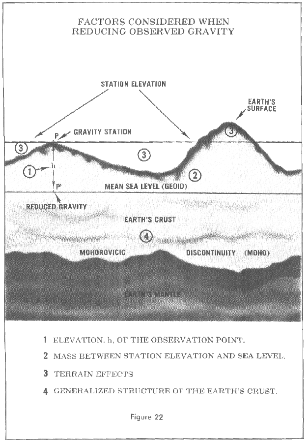
The word, anomaly, as used in geodesy refers to a deviation from the normal and can be used either for a single point or to describe a regional or area effect. To represent an area of the earth's surface, the gravity measurements (anomalies) within the area are averaged by some specialized technique to produce a mean value. This may be done for areas of different size such as the one degree by one degree square. To make use of the anomalies, the observed gravity must be reduced to a common frame of reference, the geoid-mean sea level. The reductions may take into account the elevation above (or below) sea level and can account for the mass between the point and sea level, the surrounding terrain, and the assumed structure of the earth's crust. Figure 22.
FIGURE 22 FACTORS CONSIDERED WHEN REDUCING OBSERVED GRAVITY
Undulation and Deflections by the Gravimetric Method
The method providing the basis from which the undulations of the geoid may be determined from gravity data was published in 1849 by a British scientist, Sir George Gabriel Stokes. However, the lack of observed gravity data prevented its application until recent years. In 1928, the Dutch scientist, Vening Meinesz, developed the formulas by which the gravimetric deflection of the vertical (Figure 23) can be computed.
FIGURE 23 PRODUCTS OF THE GRAVIMETRIC METHOD
The computation of the undulations of the geoid and the deflections of the vertical require extensive gravity observations. The areas immediately surrounding the computation point require a dense coverage of gravity observations and detailed data must be obtained out to distances of about 500 miles. A less dense network is required for the remaining portion of the earth. While the observational requirements for these computations appear enormous, the results well justify the necessary survey work.
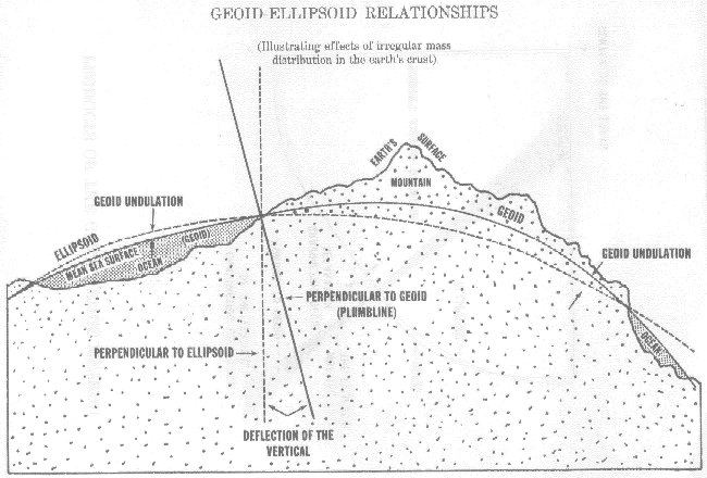
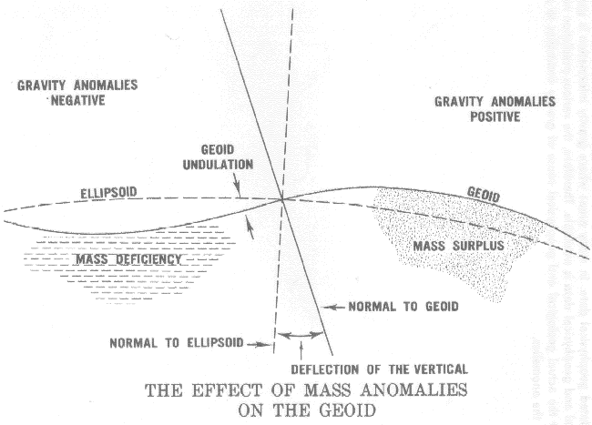
Figure 24 shows how the mass surplus of the mountains and the mass deficiency of the oceans cause the deflections of the vertical and the undulations of the geoid. A mountain mass attracts the plumb line from the normal of the ellipsoid. Likewise the mass deficiency of the ocean does not attract the plumb line. These effects of the mass anomalies contribute to the deflection of the vertical. However, both deflections of the vertical and undulation values result from density variations throughout the earth. In the area of mass surplus, the observed gravity (reduced to sea level considering only the elevation) is generally greater than the theoretical value, and the anomalies are positive. In the areas of mass deficiency, the observed (reduced in the same manner) is generally smaller than the theoretical value and the anomalies are negative. Figure 25.
FIGURE 24 GEOID-ELLIPSOID RELATIONSHIPS
FIGURE 25 THE EFFECT OF MASS ANOMALIES ON THE GEOID
The deflections and undulations computed with sufficient gravity information are considered absolue values referred to an earth-centered reference ellipsoid. In other words, the axis of rotation for the ellipsoid passes through the earth's center of gravity.
Effective use of the gravimetric method is dependent only on the availability of anomalies in sufficient quantity to achieve the accuracy desired. Successful use of Stoke's integral and Vening-Meinesz formulas depends on a good knowledge of gravity anomalies in the immediate vicinity of the point under consideration and a general knowledge of anomalies for the entire earth.
Geophysical Gravity Predictions
Measured gravity coverage is by no means complete. There are many large regions on the continents where gravity measurements are lacking or available only in small quantities. Gravity data for ocean areas has always been sparse, however, Satellite Altimetry (Chapter VII) has overcome this deficiency. In regions where an insufficient number of gravity measurements exists, some other approach must be used to obtain or predict the mean gravity anomalies for the areas.
Correlations exist between variations in the gravity anomaly field and corresponding variations in geological, crustal, and upper mantle structure, regional and local topography and various other types of related geophysical data. In many areas where gravity information is sparse or missing, geological and geophysical data is available. Therefore, the various prediction methods take into account the actual geological and geophysical cause of gravity anomalies to predict the magnitude of the anomalies.