Scientific papers advocating the use of satellites for geodetic purposes were published as early as 1956. Geodetic applications were outlined by the Smithsonian Astrophysical Observatory for data obtained from Project Vanguard during the 1958-59 International Geophysical Year. Many techniques and a great deal of knowledge were ultimately derived from this project. With this information, the constant growth of space technology, the development of electronic distance measuring devices, and the perfection of electronic data processing equipment, satellites specifically equipped for geodetic purposes have been developed, launched, observed and the data utlizied.
The first real geodetic satellite was ANNA-1B launched in 1962. Project ANNA was a truly cooperative effort involving the Department of Defense (DoD), the National Aeronautics and Space Administration (NASA), and other civil agencies. Several observational systems were developed and improved during ANNA. These systems included geodetic cameras, electronic ranging and Doppler. Knowledge gained from Project ANNA was also useful in the development of Laser ranging systems.
Two basic systems have been used for obtaining geodetic information from artificial earth satellites-optical and electronic. These systems have made it possible to perform various geodetic measurements to relate known or unknown positions to the earth's center, to relate unknown positions to existing triangulation networks, and to relate the triangulation networks to each other. Important parameters of the earth's gravitational field and values for the earth's flattening have also been obtained.
Historical Systems
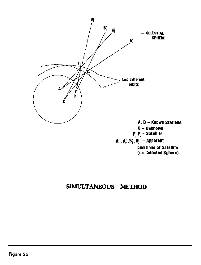
Optical tracking with the BC-4, PC-1000, MOTS, or Baker Nunn cameras consisted of photographic observations of a satellite, or flashing light on the satellite, against a background of stars. The stars, whose positions were accurately determined, provided a framework on the photographic plate or film for a determination of precise directions from camera station to satellite. Geodetic positioning work with cameras was usually performed with one camera observing simultaneously with one or more other cameras. Figure 26. Camera systems are weather dependent and that is one major reason why they are little used today. Laser systems discussed later, are also weather dependent but their extreme accuracy justifies their use and development.
The U.S. Army developed the SECOR (Sequential Collation of Range) system and the first SECOR transponder was orbited on ANNA-1B in 1962. The SECOR system continued in use through 1970. The system operated on the principle that an electromagnetic wave propagated through space undergoes a phase shift proportional to the distance traveled. A ground station transmitted a phase modulated signal which was received by the satellite-borne transponder and returned to the ground. The phase shift experienced by the signal during the round trip from ground to satellite and back to ground was measured electronically at the ground station which provided as its output a digitized representation of range.
Doppler
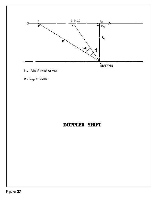
A geodetic satellite can also carry electronic signaling equipment to produce the Doppler effect which can be used for geodetic purposes. The Doppler observational system was derived from the fact that while a satellite transmitter sends a continuous unmodulated wave at a fixed frequency, the received signal at the tracking stations exhibits a shift in frequency due to the relative velocity of the satellite and observing station. A similar phenomenon may be observed with sound waves, as the source of the sound approaches and recedes from the observer. For example, the pitch of a train whistle apparently changes as the train approaches and recedes from the observer. Although the sound waves travel at a constant rate-approximately 1080 feet per second at sea level-they become crowded together as the source approaches the observer, the wave lengths become shorter, and the pitch increases. The opposite effect takes place as the source moves away.
In Figure 27, the radio source is assumed to be moving in a straight line at a specified speed. The angle Ø is used to indicate the distance between the position of the satellite at P (time t) and the point Pm (time tm) where it will be closest to the observer. If the Doppler shift were expressed in terms of Ø, as Ø decreases, the Doppler shift decreases to zero. As the satellite recedes, the received frequency decreases and the shift increases until the transmitter is out of range. This received frequency is actually a function of the transmitted frequency, velocity of propagation, and the rate of change of the slant range between the satellite and station. From observations at one station, the satellite period, time and distance of its closest approach, and its relative velocity can be determined. If observations are made from three or more stations, the orbital parameters may be derived.
Of all the satellite observation systems used so far, Doppler tracking has been the most fruitful. Reasons for this are: it is passive, not requiring any interrogation or directionally sensitive antennae at the receiver; the data obtained (Doppler counts) are in digital form; the radio frequencies used permit all weather day and night tracking; and accuracies achieved have steadily improved. Much effort has gone into identifying and eliminating the sources of error in Doppler work. Automatic portable receiving equipment is available from several suppliers. The GEOCEIVER (geodetic receiver) has played an important role in DoD observational programs. Since 1967 there have been at least four operational satellites continuously available for Doppler positioning. The National Geodetic Survey (NGS) will be using results from many Doppler stations within the United States and its possessions in support of the readjustment of the North American horizontal datum.
Laser
The laser has been adapted to measuring distances over the earth's surface and for computing ranges from earth stations to satellites and the lunar surface. The laser instrument is pointed to a target and then activated by a clock at the appropriate time. The laser beam is reflected at the target by special reflectors and the returning light is detected photoelectrically, and its time of flight measured to yield range data. The laser transmitter is mounted adjacent to some type of telescope or optical device used for receiving the reflected laser beam.
In satellite laser ranging, the interval between the outgoing and returning pulse from the satellite is measured very accurately and then transformed into a range measurement which is corrected for atmospheric refraction. Laser ranging is possible even when the satellite is in the earth's shadow and during daylight hours.
Simultaneous laser ranging to a near-earth satellite from two sites is used to determine the coordinates of one laser site relative to the fixed position of the other site and simultaneously the inter-site distance. NASA has used laser tracking since 1972 to measure the distance between points in North America. They have been testing the accuracy of laser tracking in measuring the crustal motion between points on opposite sides of the San Andreas fault and plan to make repeated measurements of baselines across the fault over a number of years. Simultaneous laser tracking has also been achieved between an east coast site and Bermuda enabling a determination of the Bermuda site's relative location (North American Datum) and the baseline between the two sites.
Laser ranging data has been incorporated into the development of world geodetic systems by the Smithsonian Astrophysical Observatory (SAO) and the Department of Defense (DoD). NASA has also included laser data in their development of gravitational models. Laser data is also being used for polar motion and earth rotation studies.
Doppler satellite surveying is a method of determining positions of points on the earth's surface by observing the Doppler shift of radio transmissions from satellites of the U.S. Navy Navigation Satellite System (NNSS). NNSS was developed for the Navy as a worldwide all-weather navigation system, and provides position fixes at time intervals of 2 hours or less. Observations of these satellites began in earnest in 1971, when portable tracking receivers became available to establish precise positions on the earth's surface. Since then, the application of Doppler satellite surveying techniques expanded, until today they are used worldwide.
System Description
The NNSS satellites currently operational are in circular polar orbits approximately 1000km above the earth's surface. The time to complete an orbit (orbital period) is approximately 105 minutes. The earth's rotation causes a satellite to cross the Equator on each revolution approximately 26° in longitude west of the previous crossing. Each satellite transmits what is referred to as the "broadcast ephemeris, " which describes the satellite's position in space. The ephemeris is a predicted orbit based on Doppler observations previously acquired by four tracking stations located in the United States.
Doppler satellite observations, reduced using the broadcast ephemeris, yield point positions with sufficient accuracy to satisfy the requirements of many NNSS satellite users. There exists a more accurate "precise" ephemeris which is generated for selected NNSS satellites from Doppler observations acquired by a tracking network (called TRANET) composed of 15 to 20 stations. The positioning accuracies for single station observations are greatly improved when using the precise ephemeris. These ephemerides are computed by the Defense Mapping Agency (DMA) to support geodetic applications requiring point positions of one-meter accuracy.
Modes of Observation
Points on the earth's surface can be positioned by various modes (point positioning, simultaneous point positioning, translocation, semishort-arc or short-arc) using either the broadcast ephemeris or the precise ephemeris.
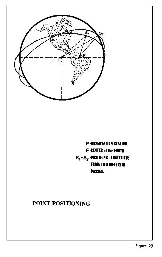
In the point-positioning mode, multiple passes collected with a single Doppler receiver are used with an ephemeris to determine an independent station position in geocentric coordinates (X,Y,Z) referenced to the Earth-centered satellite coordinate system. Figure 28. The geocentric coordinates can also be expressed in geodetic coordinates (latitude, longitude, and height above ellipsoid). Doppler positions determined with the precise ephemeris can be directly transformed to the World Geodetic System 1972 (WGS-72) discussed in Chapter VIII.
When employing the point-positioning mode as the Doppler surveying technique, the user may wish to transform the Doppler satellite-derived geocentric coordinates to the local geodetic system. The process of deriving the coordinate shifts and transforming the Doppler position requires a thorough understanding of datum transformation concepts and procedures. Occupation of a station with known local geodetic coordinates allows the transformation parameters to be derived for subsequent use with Doppler positions that were not established on a station tied to the local geodetic system.
In the simultaneous point-positioning mode, stations are simultaneously occupied in figures of two or more. The data are independently reduced as in the point-positioning mode and differenced to form relative positions. The simultaneous observations are performed during a common time period, but do not necessarily include common satellite passes.
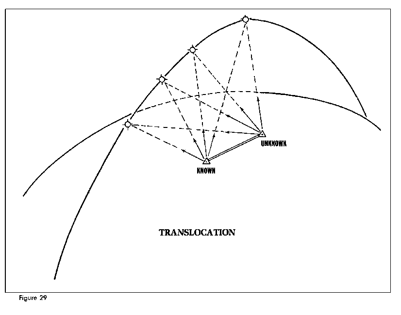
In the translocation mode, observations are simultaneously collected, usually at two stations. This mode is employed to obtain very accurate relative positions, even if the precise ephemerides are not available. When the broadcast ephemeris is used, statistical correlation performed during data reduction improves the accuracy of the positioning. The principal error sources affecting an individual satellite position fix are the ephemeris errors and refraction errors. Improved compensation for these errors is possible when the same signal is received at separate sites. The maximum spacing between sites is generally limited to approximately 500km (or less if comparability with existing control is to be maintained) so that desirable portions of satellite passes can be tracked simultaneously. During processing, enforcement of simultaneity of data points is optional. When simultaneity is enforced, it is generally referred to as rigorous translocation. Figure 29.
The short-arc and semishort-arc modes allow for small adjustments in the orbit instead of holding the satellite ephemeris fixed, as is done for the other methods. The translocation method, for example, assumes that orbit errors affect positioning of all sites in the same way, whereas the short-arc technique adjusts the reference orbit while simultaneously solving for positions. In short-arc processing, six orbital parameters are allowed to adjust. The method becomes semishort-arc processing when one to five parameters are adjustable.
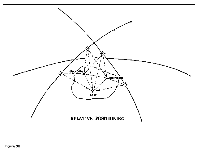
Short-arc, semishort-arc, translocation and simultaneous point positioning are all used for relative positioning. In a survey scheme, one or more base station positions are generally held fixed. These fixed positions usually have a known position on a given geodetic datum. While data are being collected at the fixed station(s), one or more additional receivers are circulated among the various unknown stations comprising the net. The data collected simultaneously are subjected to postprocessing to determine a position relative to the base stations. Figure 30.
FIGURE 30 RELATIVE POSITIONING
Although point positioning is the least accurate mode to use when only the broadcast ephemeris is available, this technique can be performed with a single receiver and fairly simple computations. Translocation and short-arc techniques are the most accurate modes when the precise ephemeris is not available, but for these modes, field and computational procedures are more complex.
Because NNSS satellites are capable of providing the broadcast ephemeris, it may be more economical to use the broadcast ephemeris rather than the precise ephemeris to meet the survey requirements. This can reduce significantly the period of occupation for a station. Data processing can also be performed more quickly because no time is lost waiting for posttracking orbital data in order to generate the precise ephemerides.
A great deal of study has been done regarding the effect of the earth's gravitational attraction on satellite motion. The fact that there are a number of perturbing factors has already been mentioned-the uneven distribution of the earth's mass, the oblateness of the earth, atmospheric drag, the effects of the planets, sun and moon, and electromagnetic effects. The perturbations are measured by observing the position of the satellite in orbit around the earth. As observational data accumulates, orbital parameters become more precisely defined and reliable earth-centered positioning becomes available. An analysis of orbital data can also be used to develop an expres- sion of the earth's external gravity field for a better interpretation of the shape of the geoidal surface through spherical harmonics. (The Appendix contains a discussion of spherical harmonics.) Although a complete analysis of orbital data requires consideration of all perturbing effects, the earth itself is the only perturbing body of major consequence in the study of near-earth satellite motion. The effects of the sun, moon, and atmosphere are removed so that only the effects of earth's shape and uneven mass distribution remain.
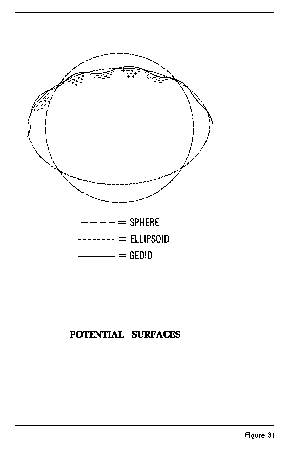
The uneven distribution of the earth's mass causes the force of gravity to vary from point to point on the surface and in external space. While force of gravity is measured at points on the surface with highly sensitive instruments, mathematical procedures are required to analyze orbital perturbations and to express the gravitational potential. The gravitational potential may be explained in terms of potential surfaces-surface to which the force of gravity is always perpen- dicular. If the earth were a perfect non-rotating sphere with homogeneous mass distribution, the potential surface would be spherical in shape. The fact that the earth is shaped more like an ellipsoid than a sphere causes the potential surface to be shaped more like an ellipsoid. Actually, the earth is neither spherical nor ellipsoidal. The potential surface bulges where there is excessive mass and it is depressed in areas of mass deficiency. The undulating surface described earlier as the geoid is a potential surface of the real earth. The diagram in Figure 31 illustrates the three surfaces just discussed.
The most convenient way to express the gravitational potential is in terms of a series of spherical harmonics mentioned above. The coefficients of the various harmonic terms are functions of the various orbital perturbations. A few are directly related to the shape of the earth and the remain- der to the uneven distribution.
While it is possible to derive harmonic coefficients from observed gravity, the method is limited due to the lack of high quality worldwide gravity coverage. The computation of coefficients from satellite data also has its limitations. There are many coefficients that are not well defined from tracking data due to the small magnitude of the orbital perturbations at geodetic satellite altitudes. In addition, satellites orbiting at different inclinations are needed to reduce the correlation between the computed coefficients. For best results, the current practice is to combine tracking data with available surface-gravity data when solving for the spherical harmonic coefficients of the earth's gravitational field.
Many pertinent developments have occurred since the last revision of this publication in February 1968. This chapter provides a place for subjects of interest that are not discussed in the other chapters. Some of the areas of new geodetic developments are: satellite laser ranging (Chapter VI), lunar laser ranging, very long baseline interferometry, satellite radar altimetry, the NAVSTAR Global Positioning System, satellite-to-satellite tracking, and inertial surveying.
In July 1969, the first men to set foot on the moon performed a number of tasks of scientific importance. Among these tasks was the deployment of a rack structure carrying an array of 100 fused silica retroreflectors designed to return some of the light of a pulsed laser beam to the telescope to which the laser equipment is coupled. These retroreflectors are a part of an Apollo experiment called LURE (Lunar Laser Ranging Experiment). LURE was designed to obtain extremely accurate measurements of the range from known locations on the surface of the earth to the lunar based retroreflectors and enable the improvement of our knowledge of the rotation of the earth and the moon about their center of mass and the moon's libration and motion about the earth.
Observations of extragalactic radio sources such as quasars, can provide the geodetic informa- tion to determine the vector separations between the antennas of two widely separated radio telescopes. The components of the vector are its length and direction. To accomplish this, it is necessary to measure very accurately the difference in the time of arrival, recorded at the two antennas, of a particular wavefront from a given (point) source of radio radiation. The phenomena called interference, in Very Long Baseline lnterferometry (VLBI), is produced by electronically superimposing the recorded signals to produce a resultant disturbance or "interference" pattern. The theoretical expression for the relative phase delay shows it to be a function of the source direction, the antenna locations, the relative clock error between the two sites, the time of day, the model atmosphere employed, the earth's tidal parameters, the radio frequency at which the observation is made, etc. Proper account must also be taken of the earth's rotation. Two of the main limiting factors in the VLBI technique are clock stability and atmospheric variations. A major goal of VLBI is to reduce the uncertainty in intercontinental baselines to the centimeter level.
VLBI derived baselines have already contributed scale information to the development of the DoD World Geodetic System in 1972. Baselines accurate to the centimeter level would function as standards of comparison for future world systems. Other applications of VLBI include the determination of polar motion, variations in the earth's rotation, and the monitoring of motions of the major plates that compose the earth's crust.
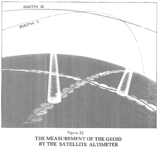
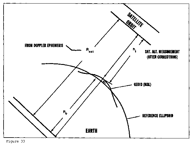
The development of orbiting space satellites from which microwave remote sensing of the earth can be achieved has provided a new instrument to the geodesist which measures directly the shape of the geoid in the ocean areas. The satellite altimeter consists of a downward ranging radar which measures the time delay from the transmission to the reception of a pulse of energy. Figure 32. The observed one-way distance from the transmitting antenna to the surface is equal to one-half the product of the time delay and the speed of light. From this distance or height, the local surface effects such as tides, winds and currents are removed to obtain the satellite height (h) above the geoid. Figure 33. With a precise Doppler ephemeris available for the satellite, the radius (Rsat) to the satellite, determined for the time of each observation, along with the radius (RØ) to the ellipsoid are readily at hand. It is then possible to compute the geoid height (N) by subtracting the radius RØ and the satellite height h from Rsat.
FIGURE 32 THE MEASUREMENT OF THE GEOID BY THE SATELLITE ALTIMETER
FIGURE 33 SATELLITE HEIGHT ABOVE THE GEOID
The Skylab spacecraft, launched in 1973, provided the first opportunity for satellite based radar altimetry. It was basically a research mission for which data was obtained for the designing of future altimeters. The GEOS-3 altimeter which incorporates many of the design features that were tested in the Skylab altimeter was launched in 1975 and provided geoid measurements over the water areas of the earth from 65°N to 65°S. The SEASAT altimeter which was a more sophisticated instrument with greater measurement capabilities was launched in June 1978 and added data from 72°N to 72°S.
Scientists, engineers, and planners have been tasked with making comprehensive studies of currently available navigation systems as part of an effort to devise a system capable of meeting the requirements of the United States after 1980. Since the late-1950's both military and civilian agencies have actively and independently pursued the idea of position determination and navigation using satellites. This resulted in the development of several systems with a multitude of specialized equipment responsive to particular mission requirements with varying degrees of accuracy and capabilities. In order to integrate the independent efforts of the military services, the Department of Defense issued a memorandum in 1973 naming the Air Force as the Executive Service for the initial development of a future Defense Navigation Satellite System (DNSS), designated the NAVSTAR Global Positioning System (GPS).
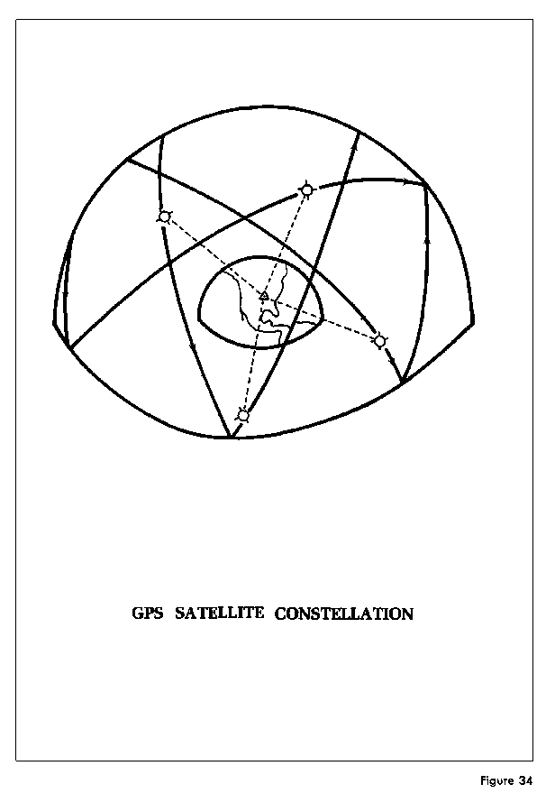
The GPS concept calls for a precise navigation system divided into three segments: space segment, control segment and user equipment segment. The space segment will consist of six orbital planes of satellites at inclinations of 55° in circular orbits at an altitude of 20,200 km. Figure 34. Each plane is to eventually contain three satellites. Each satellite will broadcast signals containing information as to its position. This broadcast will include an orbital ephemeris referenced to the DoD World Geodetic System. The control segment will be the ground stations necessary to track the satellites, monitor the system operation and periodically provide corrections to the navigation and time signals. The user segment will consist of the equipment necessary to convert the satellite signals into useful navigation information. By receiving signals from four satellites, the user, whether stationary or moving, can calculate his precise time, three-dimensional position and, if moving, his three-dimensional velocity. Position determination alone requires analysis of range information from three of the satellites in view. However, since the user's receiver clock will not be synchronized to the satellite clock, time of arrival measurements from four satellites are needed to update the user's clock.
FIGURE 34 GPS SATELLITE CONSTELLATION
When operational, GPS should satisfy the navigational accuracy requirements of many military- type missions on land, sea or in the air. Agencies also have many requirements for accurate geodetic positioning for which GPS will satisfy for years to come. These include establishing and densifying geodetic control, offshore positioning and the geodetic needs of national defense which brings in global requirements. GPS will also provide an excellent facility for determination of the position of other satellites and space vehicles while they are in lower earth orbits. This satellite- to-satellite tracking is discussed next.
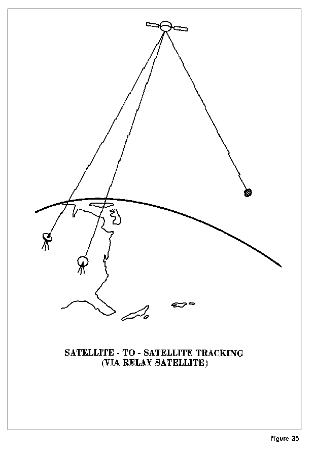
A new technique for using artificial satellites for geodetic purposes is being studied and tested. This technique uses satellites to track other satellites. There are a number of variations which may be used for specific purposes such as gravity field investigations and orbit improvement. A high altitude satellite may act as a relay from ground tracking stations to a low altitude satellite. In this way, low altitude satellites may be observed when they are not accessible to ground stations. Figure 35. In this type of tracking, a signal generated by a tracking station is received by the relay satellite and then retransmitted to a lower altitude satellite. This signal is then returned to the ground station by the same path. Two low altitude satellites can track one another obsering mutual orbital variations caused by gravity field irregularities. Several high altitude satellites with accurately known orbits may be used to fix the position of a low altitude satellite. Figure 36. These examples present a few of the possibilities for the application of satellite-to-satellite tracking.
FIGURE 35 SATELLITE-TO-SATELLITE TRACKING (VIA RELAY SATELLITE)
FIGURE 36 SATELLITE-TO-SATELLITE TRACKING (VIA SATELLITE CONSTELLATION)
Satellite-to-satellite tracking data was first collected and analyzed in a high-low configuration between ATS-6 and GEOS-3. The data was studied to evaluate its potential for both orbit and gravitational model refinement. This experiment and others that followed proved this new technique to be an important tool for space geodesy.
Inertial Navigation is the art and science of determining the position and velocity of a vehicle solely by means of sensing that vehicle's accelerations and performing the necessary integrations to determine the position and velocity on a real-time basis. The inertial system is composed of precise accelerometers to sense specific force acting on the vehicle and precise gyros to maintain orientation of the accelerometers in a chosen coordinate frame or to determine the orientation of the accelerometers with respect to that frame. Computation is performed by a small on-board computer and the position and velocity of the vehicle are displayed on a real-time basis. In the two decades that inertial navigation has been used, continued hardware developments have brought a state-of-the-art in which the inertially determined position of the vehicle is sufficiently accurate that inertial techniques can be applied to surveying.
At the heart of the inertial surveyor is the inertial measuring unit which contains three sensitive accelerometers and three precise gyros. The accelerometers are mounted as a mutually orthogonal triad on a platform which is torqued by the gyros to maintain orientation with the local vertical and local north, that is, the three axes are oriented north-east-down. The accelerometers measure the specific force on the vehicle which is the sum of the vehicle's own accelerations and the local gravity vector. The digitized output of the accelerometers are processed in real-time by a digital computer. They are integrated once to give velocity, and integrated again to give distance travelled along each sensitive axis. The system does not yield the latitude, longitude and elevation directly. To the computed distances, which are referenced to inertial space, there must be added the initial position and a conversion to latitude, longitude, and elevation accomplished. Although high quality accelerometers and gyros are used in the system, they are still subject to drift and bias. This will cause a misalignment of the platform and errors in the sensed accelerations, which results in small errors in computed velocities and positions. The currently available inertial surveying systems must stop or hover at frequent intervals. At these times, a Kalman filter process corrects for the difference between the indicated velocity and zero, and calculates normal gravity, elevation, and anomalous gravity, but only at these points where remaining errors in platform alignment are also corrected by the Kalman filter.
It was stated above that the accelerometers sense the sum of the vehicle's acceleration and the local gravity vector and that the vehicle's accelerations are needed for integration into velocity and distance travelled. However, a model of the earth's gravity field is required to remove the accelerations due to gravity. In current systems, a very simplistic model is used in which only the downward gravity component resulting from an ellipsoidal earth is computed. Thus the system cannot correct for deflection of the vertical. Further, these deflections of the vertical result in erroneous platform alignments which may introduce errors as large as 40 cm in the computed positions.
Gravity gradiometers have been suggested as a means of independently determining the components of the gravity vector on a real-time basis. A gravity gradient is simply the spatial derivative of the gravity vector. The gradient can be thought of as the rate of change of a component of the gravity vector as measured over a small distance. Hence, the gradient can be measured by determining the difference in gravity at two close but distinct points. This principle is embodied in several recent moving-base instruments. The gravity gradient at a point is a tensor, since it is the derivative of each component of the gravity vector taken in each sensitive axis. Thus, the value of any component of the gravity vector can be known all along the path of the vehicle if gravity gradiometers are included in the system and their outputs are integrated by the system computer. In theory, an accurate gravity model will be computed in real-time and a continuous map of normal gravity, elevation, and anomalous gravity will be available.