D.R. Roman
National Geodetic Survey, 1315 East-West Highway, Silver
Spring, MD, USA, 20910
Abstract. To aid in disaster mitigation, recent and impending data sets can be exploited to develop a common vertical datum for Central America. Using techniques currently being developed and tested for the North American geoid, only limited new gravity data needs to be acquired to make such a regional geoid model feasible. Sixteen recently established absolute gravity sites provide sufficient reference to ensure that these measurements could be made. In conjunction with impending high-resolution elevation and global gravity field models, these measurements can be used to determine a very accurate regional geoid, possibly sub-decimeter level.
This regional model can then be adapted to the specific datums for each country using GPS elevations on the bench marks of the respective vertical datums. In a future emergency, this model would provide the basis for converting between respective height datums and framework for coordinating rescue efforts.
Keywords. North America, Central America, gravimetric geoid, hybrid geoid, vertical datum.
The most recent respective national models, G99SSS and GSD95, had a significant overlap region (41° -58° N) and shared a common reference system, which permitted a detailed analysis of the models in that region. Each country then applied additional modeling to develop unique hybrid geoids (GEOID99 and GPS-HT, respectively) for conversion between each countrys specific vertical and horizontal datums to the decimeter level. The success met by these analyses has encouraged the formation and shaped the agenda of the Gravity and Geoid Sub-Commission for North America. The United States, Canada, Mexico, and other countries have joined to develop a unified regional geoid. However, numerous improvements will be required to develop such a regional geoid.
Impending satellite gravity mission data from the CHAMP as well as future GRACE and GOCE data are expected to generate global geoid models that have significantly lower errors of commission (< 1 cm) for features of 200-300 km wavelength (Tscherning et al. 2000). Use of these models for the reference gravity field will reduce errors in the residual values and improve the resulting gravimetric geoid. SRTM and VCL mission data will also improve the quality and spatial resolution of elevation models, which reduces the errors in the computations for the gravitational attraction and potential of the terrain. Finally, a more rigorous method for determining Helmert anomalies is being developed that will also reduce errors in the gravimetric geoid. Each country will then apply their own models to convert from this common model into their individual reference datums.
This approach may be adapted for Central
America, where each nation has limited information outside of their territory
and their own unique vertical datums. Recent disasters, such as Hurricane
Mitch, point to the need for such a unified vertical datum to provide a
sufficient framework for coordinating future assistance, as well as land
registration and cadastre issues. Providing such a framework would support
the goals expressed by Doyle (1999) for the National Geodetic Survey (NGS)
to develop a modern geodetic reference system for El Salvador, Guatemala,
Honduras, and Nicaragua.
The first thing to consider is the justification for using a geoid over a quasi-geoid, or more accurately, orthometric heights over normal heights. Convincing arguments have been made for orthometric heights (Holdahl 1984) and normal heights (Heiskanen and Moritz 1967). While orthometric heights require extensive knowledge of the gravity field, it is just that reason that warrants their use. Given the extensive knowledge and available data sets, it is incumbent on governmental agencies to generate such models. With a model of the gravity field from the surface to the geoid at hand, anyone subsequently desiring to transform from orthometric to normal heights need only apply it. However, if normal heights are developed and orthometric heights are later desired, the development of such a model will then be required. Clearly, this is a task best suited to national and international organizations that have access to such data and methods. It should not be left to those researchers desiring to use height models in their studies that may not have access to sufficient resources to accomplish this.
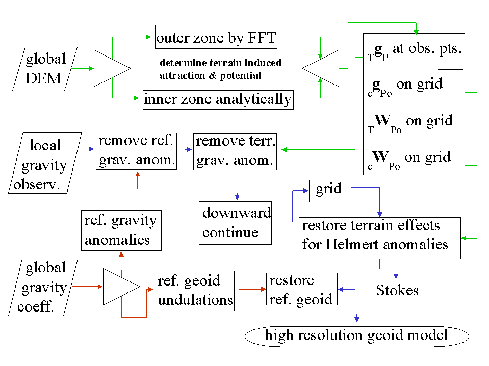
With that understanding then, the development of a gravimetric geoid model follows as a mechanism to readily convert between ellipsoidal and orthometric heights. The method summarized here seeks to break the gravity field into three components and solve them separately. In fact the long wavelength component will be derived from a global reference gravity model. The short wavelength will be determined from the terrain. Both of these components will be removed from available gravity observations, which will then reflect the intermediate wavelength signal. A flowchart depicting the determination of these three signals and the generation of a gravimetric geoid is given in Figure 1. Paths shown in red highlight the use of the reference model, paths in green show the determination of the terrain effects, while paths shown in purple highlight the main path to determining Helmert anomalies and then a gravimetric geoid model.
The expected accuracy of global gravity models in the near future is expected to vastly improve with commission errors below 1-2 cm at wavelengths of 200-300 km (Tscherning et al. 2000). Use of a remove and restore technique (Baiæ and Rapp 1992) will then result in significantly reduced errors in the residual signal that will be manipulated.
The approach discussed in Roman and Smith (2001) develops the North American gravimetric geoid by removing the terrain effects, downward continuing the residual values, and then restoring the effects of the condensed terrain to generate Helmert anomalies (Heiskanen and Moritz 1967).
To this end, the gravitational attraction of the terrain (TgP) will be calculated and removed from the gravity observations. It will be split into inner and outer zones to reduce computation times. Smith et al. (2001) showed that the effects of using FFT to determine gravitational attraction and potential for both condensed and 3D masses is negligible beyond about a 4 degree cap radius from the point of interest (P). Inside that zone, DEMs are employed to capture the spherical relationships between the points and more accurately determine the attraction. With available or pending 1 and 3 arc-second DEMs (Smith and Roman 2001a, NIMA 2001), the signal that may be determined is limited mainly by the computational facilities available to a researcher.
Additionally, the DEMs will be used to construct grids for the attraction and potential of the condensed terrain (cgPoand cWPo), as well as the potential of the actual terrain (TWPo), all on the geoid. This will capture the short wavelength gravity signal represented by the terrain to the resolution of the grid generated and facilitate later incorporation of this signal into Helmert anomalies.
The resulting point values should be composed mainly of intermediate features in the gravity field with sources deriving from variations in the Moho depth and lateral density variations. This signal should be sufficiently smooth to reduce errors resulting from downward continuation. It should also sufficiently sample the intermediate field to permit the use of minimum curvature (Smith and Wessel 1990) to generate a grid at the same interval as that of the above terrain effects.
Once these terrain effects are restored, these extremely high resolution grids represent residual Helmert anomalies and may be processed using the Stokes integral to determine a best fitting residual gravimetric geoid. Adding the reference geoid derived from the selected global coefficient model will create an equally high-resolution regional gravimetric geoid model.
For a specific country, GPS-derived ellipsoid heights at leveled bench marks (GPSBMs) provide control information for generating a hybrid geoid model that can be used to specifically, easily, and accurately transform heights between ellipsoidal and orthometric heights (Smith and Milbert 1999, Smith and Roman 2001b).
To adapt such a process to Central
America doesnt require much new data. The global gravity field and elevations
models (e.g., Tscherning 2000, NIMA 2001) will be available for these regions,
also. Likewise, extensive leveling observations (bench marks) have been
made in most countries as is seen in Table 1.
However, most of these bench marks have not been occupied with GPS equipment, so the information required to generate geoid control heights (GPSBMs) is only partially complete.
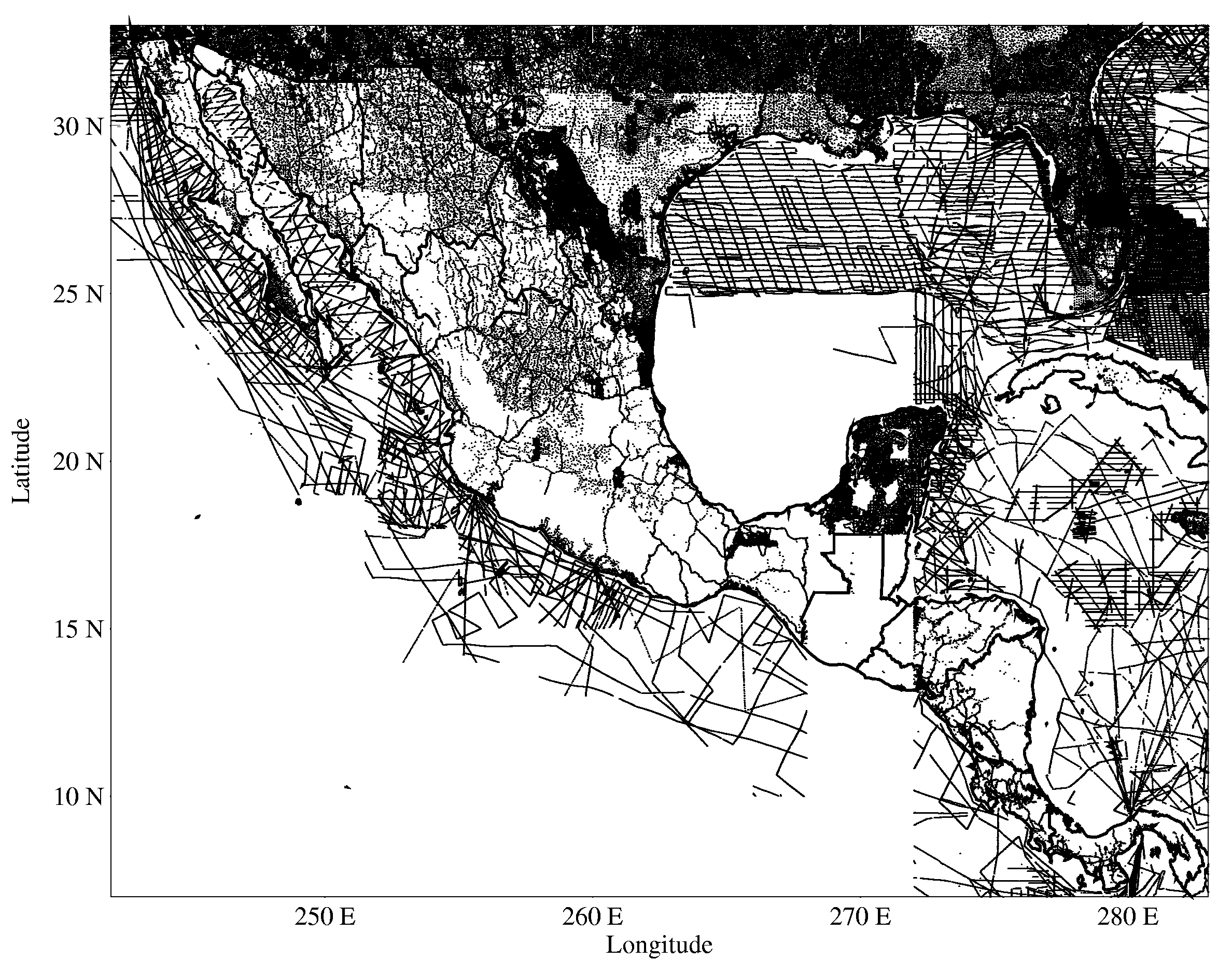
In addition to the deficiency of GPSBMs, the quantity and, in some cases, quality of gravity observations presently available is lacking. In Figure 2, several coverage gaps are associated with earlier restrictions on gravity data available for the region.
These issues must be addressed to ensure that gravity observations are available for a minimum 6 arc-minute grid of values. Kearsley (1986) studied the relationship between errors in gravity observations and their geographic spacing on derived gravimetric geoids. He found that one milliGal errors in the observed data could propagate to greater than one centimeter errors in the geoid if the data were more than 10 km apart. Given the accurate knowledge of the short wavelength gravity field implied by the high-resolution DEMs, losing accuracy in the final gravimetric geoid due to insufficient sampling of the intermediate gravity is unacceptable.
Table 1. Central American datum information
| CountryPoint of Contact | |||
| Datum Name | Height System | Reference Stations | # of |
| Name | System | BMs | |
| El Salvador Victor Araujo | |||
| Cutuco | normal | 1: Acajutla | 5000- |
| 6000 | |||
| Honduras VirigilioAlvarenga Noriego | |||
| Puerto | normal | 1: Puerto Cortes | 6000- |
| Cortes | 2: Muelle Henecan | 7000 | |
| 3: Puerto Castilla | |||
| Nicaragua Ganzalo Medina | |||
| Corinto | orthometric | 1: Corinto | 10001 |
| 1950 | |||
| Guatemala Fernando Boiton | |||
| Puerto | normal | 1: Puerto Quetzal | 2000 |
| San Jose | |||
| Belize Rolando Rosado | |||
| Belize | orthometric | 1: Government | 52 |
| House | |||
| 1 observed 600 stations ~1960 and 400 stations in 2001 | |||
| 2 observed 58 km of leveling through 5 major stations | |||
To help mitigate this, sixteen absolute gravity sites were recently established in the region as well as sites associated with the regional High Accuracy Reference Network (HARN). These stations will serve as the basis for expanding the surface gravity database to meet the above requirements and are shown in Figure 3.
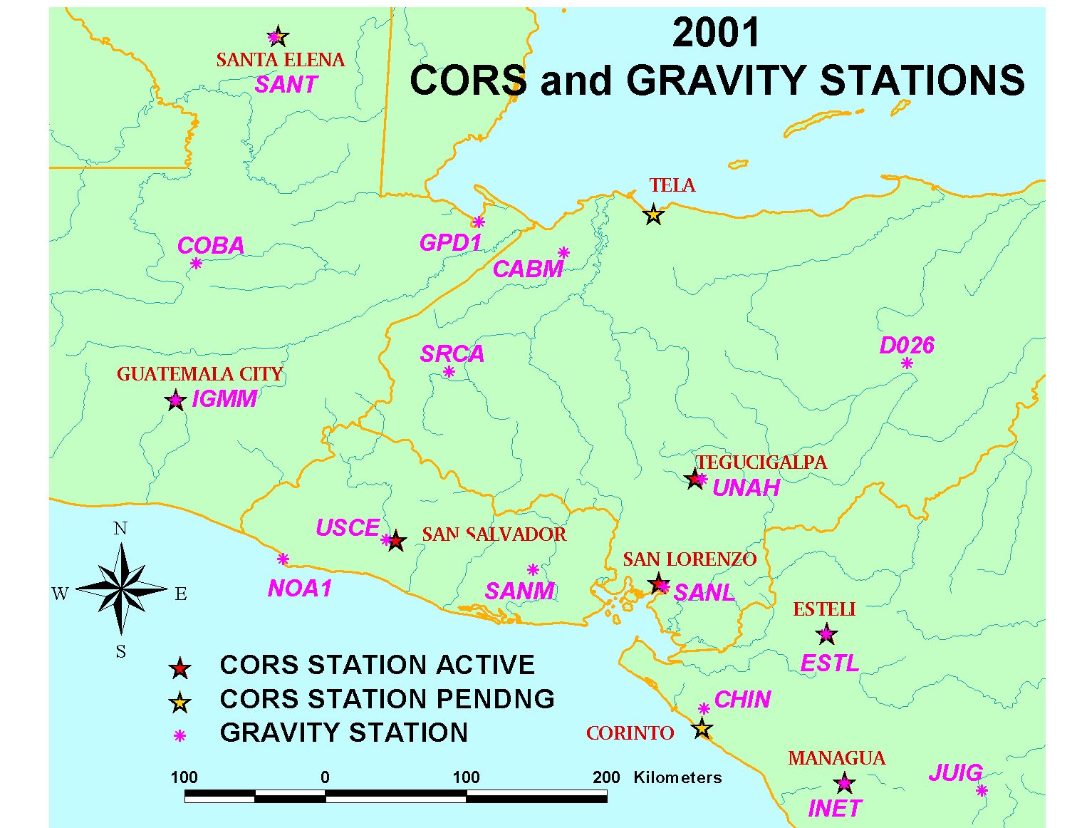
These hybrid models and the HARN will provide the basis for rapid determination of orthometric elevations throughout the region. The conversion surfaces used to make the hybrid models may also be used to transform heights between various countries to facilitate cross-border work.
New techniques are being studied to develop extremely high-resolution gravimetric geoids for North America. In order to adapt these techniques to the Central America, more relative gravity observations are needed. While sixteen new absolute gravity sites have now been established in the region, the available relative gravity observations remain insufficient to determine the gravimetric geoid to a decimeter. The absolute sites must be utilized to increase he spatial density of the relative gravity measurements throughout the region to a minimum spacing of about 6 arc-minutes. Combined with the expected improvements in the elevation and reference gravity field models, a reliable regional gravimetric geoid will then be available for Central America.
The regional High Accuracy Reference Network will be tied into the Continuously Operating Reference Stations to provide a framework for determining ellipsoidal elevations at bench marks. These control points can then be used to transform the regional gravimetric geoid into each countrys specific vertical datum to serve their own internal needs, while serving as a mechanism for relating heights across national boundaries.
References
Doyle, D.R. (1999) Development and implementation of a geodetic framework for El Salvador, Guatemala, Honduras, and Nicaragua (as provided under the Hurricane Mitch reconstruction program for Central America). http://www.ngs.noaa.gov/PROJECTS/Mitch/ plan112399.htm.
Heiskanen, W.A. and H. Moritz (1967). Physical Geodesy. W.H. Freeman and Company, San Francisco.
Holdahl, S.M. (1984). Aspects of a new height system for North America. In Technical papers of ASPRS-ACSM annual conference from March 13-18, 1983, pp. 63-77.
Kearsley, A.H.W. (1986). Data requirements for determining precise relative geoid heights from gravimetry. Journal of Geophysical Research, 91 (B9), pp. 9193-9201.
McCown, S., A. Graumann, T. Ross, and N. Lott (1999). Mitch: The deadliest Atlantic Hurricane since 1780. http:// www.ncdc.noaa.gov/ol/reports/mitch/mitch.html.
NIMA (2001). Shuttle Radar Topography Mission. http:// 164.214.2.59/srtm/navigation.html
Roman, D.R. and D.A. Smith (2001). Recent investigations toward achieving a one centimeter geoid. Proceedings of the GGG2000 an IAG Symposium in Banff, Alberta, Canada from July 31 - August 4, 2000, (in press).
Smith, D.A. and D.G. Milbert (1999). The GEOID96 high resolution geoid height model for the United States. Journal of Geodesy, 73 (5), pp. 219-236.
Smith. D.A., D.S. Robertson, and D.G. Milbert (2001). Gravitational attraction of local crustal masses in spherical coordinates. Journal of Geodesy (in press).
Smith, D.A., and D.R. Roman (2001a). A new high resolution DEM for the Northwest United States. Surveying and Land Information Systems, 61 (2), pp. 103-112.
Smith, D.A., and D.R. Roman (2001b). GEOID99 and G99SSS: One arc-minute models for the United States. Journal of Geodesy (in press).
Smith W.H.F., and P. Wessel (1990). Gridding with continuous curvature splines in tension. Geophysics, 55 (3), pp. 293-305.
Tscherning, C.C., D. Arabelos and G.
Strykowski (2001). The 1-cm geoid after GOCE. Presented at GGG2000 an
IAG Symposium in Banff, Alberta, Canada from July 31 - August 4, 2000.