main |
next |
prev
3. Processing
- Separately, each subnetwork for each day was processed using the
PAGES software developed at the GRD [Mader et al., 1995]. PAGES had been
modified to estimate OLT parameters.
- The IGS precise ephemerides were used with no additional orbit adjustment.
- The Saastamoinen zenith delay models [Saastamoinen, 1972] and NMF
mapping functions [Niell, 1996] with a seasonal model for surface temperature,
pressure and relative humidity were used to remove tropospheric effects. In
addition, a piece-wise, linear correction to the zenith wet delay was
estimated at two hour intervals.
- The solid earth tide was modeled [Cartwright and Taylor, 1971,
Cartwright and Edden, 1973] and removed.
- No a priori ocean or atmospheric loading models were applied.
- Phase ambiguities were not fixed to integer values.
- Parameters for the eleven most commonly significant tidal terms, the
position and velocity for each site were included. Only the vertical
deformation caused by OLT was considered because of limitations in
computational resources.
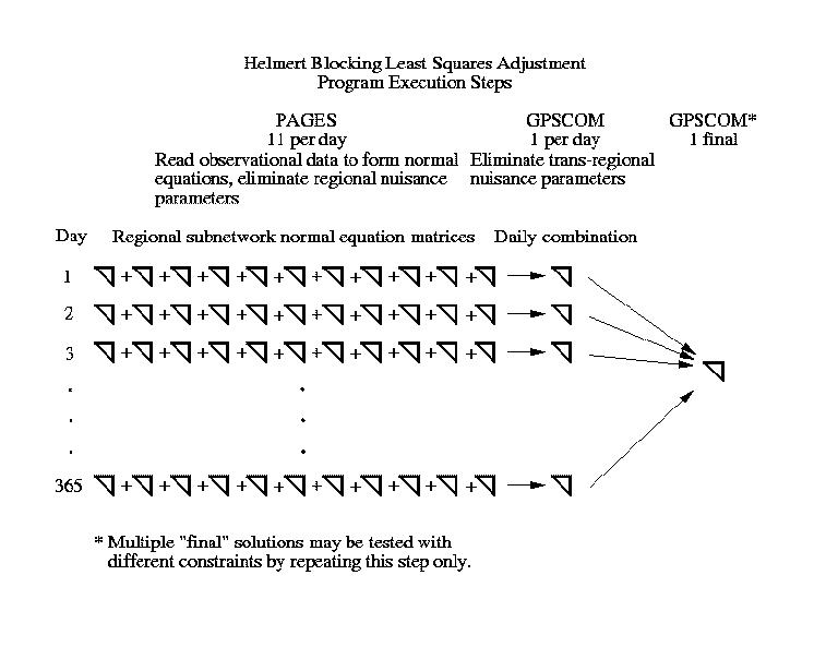
- For each day, each subnetwork was separately processed using PAGES
to the point were all phase ambiguity parameters were reduced by Gaussian
elimination, and zenith wet delay parameters for all sites except those common
to the core subnetwork were reduced. These ambiguities and tropospheric
parameters were discarded as "nuisance" parameters.
- The portion of the normal matrix containing the core subnetwork
zenith wet delay parameters, and all station position, velocity and OLT
parameters were saved for further processing.
- The core and regional subnetwork matrices were combined day-by-day
using GPSCOM, a Helmert blocking tool also developed at the GRD. At this
point, the remaining "nuisance" parameters, i.e. tropospheric delays
from the core subnetwork sites, were reduced and eliminated. This step is
necessary because the core subnetwork connects the regional subnetworks, and
thus, even "nuisance" parameters such as the zenith wet delays, can
not be eliminated until all data involving those parameters have been brought
together in the normal equation matrix.
- Finally, the 365 daily matrices, each now containing only
station position, velocity and OLT parameters for the entire network, were
then combined into a single solution, again, using GPSCOM.
Descriptive figure of the Helmert blocking steps.
Ultimately, 72,000 station-days (146 gigabytes of GPS data) were processed.
5,419 "global" parameters were retained. 71,000,000
"nuisance" parameters were reduced and eliminated.