U.S. Center of Population: 2020
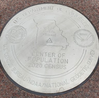
Each decennial census since 1960, NGS has partnered with the U.S Census Bureau to establish a geodetic control mark at or near the U.S. center of population, which for the 2020 Census, falls in the aptly named Hartville, Missouri. On September 21, 2022, National Geodetic Survey, the Census Bureau, and the city of Hartville unveiled a functional commemorative survey mark, honoring the city's distinction as the "heart" of the country, and connecting us all to Hartville through the invisible infrastructure of the National Spatial Reference System (NSRS).
The Mean Center of Population, as defined by the Census Bureau, is "the place where an imaginary, flat, weightless, and rigid map of the United States would balance perfectly if all residents were of equal weight." Since it was first measured in 1790, the Mean Center of Population has tracked the movement of Americans out West and to the South. Beginning with the 1960 census, the Census Bureau and NGS have worked together to establish a geodetic control mark at or near the computed location of the Mean Center of Population.
The 2020 Mean Center of Population is in central southern Missouri. This spot in Missouri's Wright County is 14.6 miles from Hartville, a town with a 2020 Census population of 594. This is the fifth decade in a row that the national center of population has been located in Missouri. In 1980, the center of population moved from Illinois to a location near DeSoto, Missouri, and has remained in the state ever since. In 2010, the center of population was in Plato, about 30 miles from the 2020 center.
The geodetic survey mark that NOAA and the Census Bureau unveiled at Hartville City Park has become part of the physical national geodetic infrastructure that makes up the National Spatial Reference System, the nation's precise coordinate system that serves as the foundation for accurate mapping and charting in America. Just as Hartville is now at the "heart" of the American population, geodesy, or accurate location science, is at the center of applications that literally help people navigate their everyday lives whether they are on land, sea, or in the air. Geodesy and geodetic infrastructure–like survey marks–are central to the work of surveyors who play vital roles before, during, and after development and in infrastructure projects conducted by architects, engineers, and construction professionals.
The mark is made of stainless steel and is set into a 2,000 lb rose granite monument which is partially buried and cemented into the ground to provide a stable and consistent reference point. The mark was installed with help from the City of Hartville Public Works Department, and the coordinates were determined by a GPS survey conducted by Missouri State Surveyor's Office, Missouri Department of Transportation, U.S. Forest Service, and supported by Missouri Society of Professional Surveyors. The official coordinates for the mark will be published by the National Geodetic Survey on a survey mark datasheet when the project processing is completed.
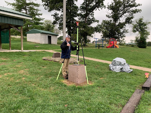
Credit: NOAA - NGS Central Plains Regional Geodetic Advisor, Brian Ward, conducts a GPS observation on the commemorative survey mark in Hartville City Park.
- Designation: TBD once survey is processed
- PID: TBD once survey is processed
- Datasheet: TBD once survey is processed
- Year: 2022
- Location: Hartville, Missouri
- Latitude/Longitude: +37.415725 / -092.346525
- Event Commemorated: Designation of Hartville, MO as the 2020 Decennial Census Center of Population

