| February 24 2026 |
 |
||
|
 |
 |
|
|
|
Imaging Spectrometers gather data over
a wide band of the electromagnetic spectrum in many small bandpass channels.
Such data (often called hyperspectral data) can be used to accurately determine
the composition of the ground cover in a scene. When the images are acquired
at high spatial resolution, the resulting data provide a robust characterization
of the earth's surface. The scene above is a 4 meter resolution, 3 channel
composite of Airborne
Visible and Infrared Imaging Spectrometer (AVIRIS) data taken over
the entrance to St. Louis Bay, Mississippi. The pronounced linear feature
at scene center is the railway bridge joining Bay St. Louis and Pass Christian.
The bridge is approximately 1.7 nautical miles in length.
The high quality of this image clearly illustrates the usefulness of hyperspectral data for high resolution mapping purposes. These data were acquired in October of 1998 as part of a collaboration between NOAA/NOS/NGS and the NASA/Jet Propulsion Laboratory (JPL) to deploy the AVIRIS instrument in a NOAA Twin Otter aircraft. Hyperspectral datasets of this quality were flown both in 1998 and 1999 to support a wide range of experiments by researchers throughout the remote sensing community. At NGS, we have experiments underway to explore the use of these data for shoreline mapping, coastal change detection, and airport obstruction charting. The deployment of AVIRIS in a NOAA twin otter was the first low altitude operational use of this sensor. AVIRIS data from these experiments have spatial resolutions on the order of 4 meters, but some scenes with 2 meter resolution have been acquired. The integration of GPS and inertial navigation technologies with the image data enables JPL engineers to construct the high quality scenes. In the photo at below left, the NOAA pilot and JPL AVIRIS system operator are shown alongside the Twin Otter aircraft at Harrisburg, PA airport. The right photo shows the installation of AVIRIS in the Twin Otter camera bay. |
|
|
|
|
The scenes below are 3 channel composites
of the calibration range at the NASA Stennis Space Center in Stennis, Mississippi.
The left image has a nominal resolution of 2.1 meters. The right image
was flown on the same flight path at higher altitude and has a nominal
resolution 4.0 meters. Inspection of the fan array on the two scenes
provides a visible interpretation of how spectra are mixed in larger pixel
sizes, and shows the desirability of high geometric resolution for both
precise location and identification of targets in the hyperspectral cube.
|
|
|
|
|
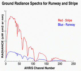
Field spectrometers are used to acquire ground level spectral signatures that can be used to remove atmospheric effects and provide ground truth for classification of the airborne hyperspectral scenes. The photo shows a NOAA engineer gathering ground radiance data. The plot shows radiance data for the runway asphalt and white center line stripes at Harrisburg International Airport. |
|
|
Spectral Plot
 |
See more information about the Harrisburg, Pennsylvania project.
See more information on the NOAA/NASA/JPL
collaboration.
|
National Oceanic and Atmospheric
Administration/
National Ocean Service/ National Geodetic Survey Last modified: May 16 2017 |
|