| May 5 2024 |
|
||
|
 |
Digital Elevation Model
(DEM) of Castle Bay, Alaska
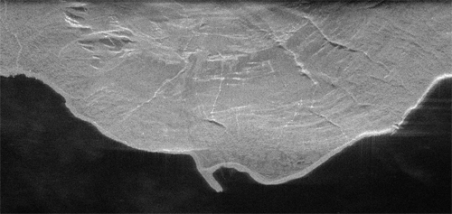
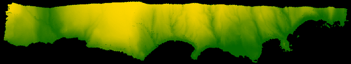
| The skies over the coast of Southwest Alaska are often too cloudy to permit photogrammetric data collection. NGS has established a technology validation site at Castle Bay, in Southwest Alaska, to experiment with various types of mapping imagery. Synthetic Aperture Radar (SAR) systems may well provide imagery with sufficient metric characteristics to support shoreline mapping applications. The image above is a digital elevation model (DEM) formed from SAR data, and rendered by engineers at NGS. The scene is of a 5 nautical mile stretch of the north coast of Castle Bay. The DEM used in this image was constructed at Sandia National Labs (SNL) from interferometric SAR (IFSAR) data acquired by NGS in the Fall of 1997, aboard the ERIM DCS aircraft. |
| The scene below shows a 1 nautical mile section of this same area. The image is a 1 meter resolution slant plane image formed by engineers at NGS using image formation code written at SNL, and from the raw phase history data acquired aboard the ERIM DCS aircraft. The pronounced drainage pattern visible in the scene is on the south slope of Chiniak Mountain, a 3400 ft. peak located approximately 1 mile from the coast. This project was a collaboration between NGS, the Office of the Coast Survey, and the United States Air Force. Preliminary results from the experiments were published at the ISPRS Commission III Symposium in Columbus, Ohio in July of 1998. |
|
|
SAR Image of the Northwest Arm of Castle Bay, Alaska
|
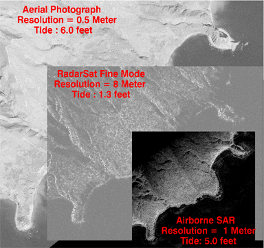
| We have mapped the North shore of Castle
Bay using photogrammetry, airborne SAR, and RADARSAT fine mode imagery.
The figure below illustrates the scale and phenomenology differences among
the photography, airborne SAR, and spaceborne SAR data. The area shown
in the scene is about 1 nautical mile.
The aerial photography was flown at 25,000 feet with a resolution of about .5 meters. The airborne SAR was flown at 14,000 feet with a depression angle of 30 degrees and with a resolution of 1 meter. The RADARSAT imagery was acquired from space and has a resolution of approximately 8 meters. Aside from scale differences, the images differ because of phenomenology, SAR layover effect, and height of tide. We have ongoing experiments to assess the accuracy of the SAR derived shoreline by comparing it to the photogrammetrically derived shoreline. |
| Scale differences:
photo, airborne and spaceborne SAR
|
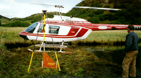
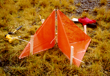
| In support of the airborne SAR data collection in the Fall of 1997, NGS conducted a major field campaign to deploy radar reflectors. The photo at below left shows a NGS surveyor using GPS to position a radar reflector. The right photo shows a detailed view of the reflectors, which were 0.6 meter triangles constructed of aluminum. The field team deployed reflectors at 45 sites in the Castle Bay area. |
|
Positioning a radar reflector
|
Close-up
of radar reflector
|
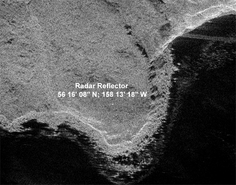
| The image below illustrates the appearance of a .6 meter reflector in a 1 meter resolution SAR image. This image was formed by NGS engineers using the SNL image formation code. |
|
Radar reflector in the SAR image
|
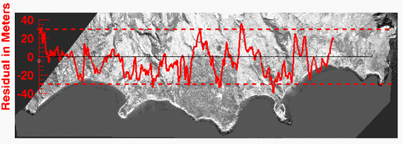
| The image below shows an analysis of shoreline mapped from the RADARSAT fine mode imagery. The residual vector represents the difference from the photogrammetric shoreline plotted in its correct geographic orientation over an orthophotograph of Castle Bay. Over the segment of the coast shown the two shorelines agree to within 28 meters at the 95% confidence level. We have examined the causes of this difference and we documented our results in a paper presented at the IEEE Oceans '99 conference in Seattle, Washington in September of 1999. |
|
Radarsat analysis
|
|
National Oceanic and Atmospheric
Administration/
National Ocean Service/ National Geodetic Survey Last modified: May 16 2017 |
|