Special Report
Results of the General Adjustment of the
North American Vertical Datum of 1988
David B. Zilkoski, John H. Richards, and Gary M. Young
American Congress on Surveying and Mapping
Surveying and Land Information Systems, Vol. 52, No. 3, 1992, pp.133-149
ABSTRACT. For the new general adjustment of the North American Vertical Datum of 1988 (NAVD 88), a minimum-constraint adjustment of Canadian-Mexican-U.S. leveling observations was performed holding fixed the height of the primary tidal benchmark, referenced to the new International Great Lakes Datum of 1985 (IGLD 85) local mean sea level height value, at Father Point/Rimouski, Quebec, Canada. IGLD 85 and NAVD 88 are now one and the same. Father Point/Rimouski is an IGLD water-level station located at the mouth of the St. Lawrence River, and is the reference station used for IGLD 85. This constraint satisfies the requirements of shifting the datum vertically to minimize the impact of NAVD 88 on U.S. Geological Survey mapping products, and provides the datum point desired by the IGLD Coordinating Committee for IGLD 85. The only difference between IGLD 85 and NAVD 88 is that IGLD 85 benchmark values are given in dynamic height units, and NAVD 88 values are given in Helmert orthometric height units. The geopotential numbers of benchmarks are the same in both systems. Preliminary analyses indicate differences for the conterminous United States between orthometric heights referred to NAVD 88 and to the National Geodetic Vertical Datum of 1929 (NGVD 29) range from -40 cm to +150 cm. In Alaska, the differences range from +94 cm to +240 cm. However, in most "stable" areas, relative height changes between adjacent benchmarks appear to be less than 1 cm. In many areas, a single bias factor, describing the difference between NGVD 29 and NAVD 88, can be estimated and used for most mapping applications. The overall differences between dynamic heights referred to IGLD 85 and to International Great Lakes Datum of 1955 will range from 1 cm to 40 cm. The use of Global Positioning System (GPS) data and a high-resolution geoid model to estimate accurate GPS-derived orthometric heights will be directly associated with the implementation of NAVD 88 and IGLD 85. It is important that users initiate a project to convert their products to NAVD 88 and IGLD 85. The conversion process is not a difficult task, but will require time and resources.
History of U.S. National Geodetic Vertical Datums
The first leveling route in the United States considered to be of geodetic quality was established in 1856-57 under the direction of G.B. Vose of the U.S. Coast Survey (precedessor of the U.S. Coast and Geodetic Survey and, later, the National Ocean Service). The leveling survey was required to support current and tide studies in the New York Bay and Hudson River areas. The first leveling line officially designated as "geodesic leveling" by the Coast and Geodetic Survey followed an arc of triangulation along the 39th parallel. This 1887 survey began at benchmark A in Hagerstown, Maryland.
By 1900, the vertical control network had grown to 21,095 km of geodetic leveling. A reference surface was determined in 1900 by holding elevations referenced to local mean sea level (LMSL) fixed at five tide stations. Data from two other tide stations indirectly influenced the determination of the reference surface. Subsequent readjustments of the leveling network were performed by the Coast and Geodetic Survey in 1903, 1907, and 1912 (Berry 1976).
The next general adjustment of the vertical control network was accomplished in 1929. By then, the international nature of geodetic networks was well understood, and Canada provided data for its first-order vertical network to combine with the U.S. network. The two networks were connected at 24 locations through vertical control points (benchmarks) from Maine/New Brunswick to Washington/British Columbia. Although Canada did not adopt the "Sea Level Datum of 1929" determined by the United States, Canadian-U.S. cooperation in the general adjustment greatly strengthened the 1929 network. Table 1 lists the kilometers of leveling involved in the readjustments and the number of tide stations used to establish the datums. Figure 1 depicts the U.S. portion of the primary network used in the 1929 readjustment.
Analyses of NGVD 29 General Adjustment
It would have been helpful to the NAVD 88 datum definition study to recreate the 1929 general adjustment using geopotential differences. This was not possible, because most of the original data used in the NGVD 29 adjustment were not placed in computer-readable form. Many of the original leveling lines were releveled, and because the old leveling was not essential to the readjustment project, these older data were not automated.
Table 1. Amount of leveling and number of tide stations involved in previous readjustments.
|
Year of Adjustment |
Kilometers of Leveling |
Number of Tide Stations |
|---|---|---|
|
1900 1903 1907 1912 1929 |
21,095 31,789 38,359 46,468 75,159 (U.S.) 31,565 (Canada) |
5 8 8 9 21 (U.S.) 5 (Canada) |
FIGURE 1 [First-order vertical control used in 1929 adjustment.]
However, in support of NAVD 88, the National Geodetic Survey (NGS) Vertical Network Branch (VNB) converted the historic height difference links involved in the 1929 general adjustment to computer-readable form. The 1929 general adjustment was recreated by constraining the heights of the original 26 coastal stations. Free-adjustment results were then compared with the general adjustment constrained results. Several differences exceeded 50 cm. A large relative difference, 86 cm, exists between St. Augustine, Florida, and Fort Stevens, Oregon. This is indicative of the amount of distortion present in the 1929 general adjustment (Figure 2).
FIGURE 2 [Height differences between NGVD 29 free adjustment and NGVD 29 constrained (published) adjustments.]
North American Vertical Datum of 1988
Approximately 625,000 km of leveling have been added to the National Geodetic Reference System (NGRS) since NGVD 29 was created (figure 3). In the intervening years, discussions were held periodically to determine the proper time for the inevitable new general adjustment. In the early 1970s, NGS conducted an extensive inventory of the vertical control network. The search identified thousands of benchmarks that had been destroyed, due primarily to post-World War II highway construction, as well as other causes. Many existing benchmarks were affected by crustal motion associated with earthquake activity, postglacial rebound (uplift), and subsidence resulting from the withdrawal of underground liquids. As indicated earlier, other problems (distortions in the network) were caused by forcing the 625,000 km of leveling to fit previously determined NGVD 29 height values. Some observed changes, amounting to as much as 9 m, are discussed in previous reports (Zilkoski, Balazs, and Bengston 1989; Zilkoski 1986; Zilkoski and Young 1985).
To perform the new general adjustment, NGS prepared a budget initiative for fiscal-year 1977 to finance this project, a revision of which later was approved. The adjustment project, called the North American Vertical Datum of 1988 (NAVD 88), formally began in October 1977. The NAVD 88 project has dominated VNB activities since approval and funding in 1977. Major NAVD 88 tasks are described in detail in previous reports (Zilkoski 1986; Zilkoski and Young 1985).
An important feature of the NAVD 88 program was the releveling of much of the first-order NGS vertical control network in the United States. The dynamic nature of the network requires a framework of newly observed height differences to obtain realistic, contemporary height values form the readjustment. To accomplish this, NGS identified 81,500 km (50,600 miles) for releveling. Replacement of disturbed and destroyed monuments preceded the actual leveling. This effort also included the establishment of stable "deep-rod" benchmarks, which will provide reference points for future "traditional" and Global Positioning System (GPS) leveling techniques. Field leveling of the 81,500 km network was accomplished to Federal Geodetic Control Committee (FGCC) first-order, class II specifications, using the "double-simultaneous" method (Whalen and Balazs 1976).
FIGURE 3 [Vertical control used in 1988 adjustment.]
Helmert blocking consisted of the partitioning of 709,000 unknowns (approximately 505,000 permanently monumented benchmarks and 204,000 temporary benchmarks) and associated observations into manageable blocks, and performing the equivalent of a simultaneous least-squares adjustment of the entire data set. Helmert blocking began in a production mode in October 1989, with the new general final adjustment completed in June 1991.
For the general adjustment of NAVD 88 and the International Great Lakes Datum of 1985 (IGLD 85), a minimum-constraint adjustment of Canadian-Mexican-U.S. leveling observations was performed. The height of the primary tidal benchmark at Father Point/Rimouski, Quebec, Canada, was held fixed as the constraint (Figures 4 and 5). Therefore, IGLD 85 and NAVD 88 are one and the same. Father Point/Rimouski is an IGLD water-level station located at the mouth of the St. Lawrence River and is the reference station used for IGLD 85. This constraint satisfies the requirements of shifting the datum vertically to minimize the impact of NAVD 88 on U.S. Geological Survey (USGS) mapping products, and provides the datum point desired by the IGLD Coordinating Committee for IGLD 85. The only difference between IGLD 85 and NAVD 88 is that IGLD 85 benchmark values are given in dynamic height units, and NAVD 88 values are given in Helmert orthometric height units. Geopotential numbers for individual benchmarks are the same in both systems.
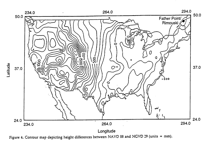
Analyses indicate that the overall differences for the conterminous United States between orthometric heights referred to NAVD 88 and to NGVD 29 range from -40 cm to +150 cm (Figure 4). In Alaska the differences range from approximately +94 cm to +240 cm. However, in most "stable" areas, relative height changes between adjacent benchmarks appear to be less than 1 cm. In many areas, a single bias factor, describing the difference between NGVD 29 and NAVD 88, can be estimated and used for most mapping applications. The overall differences between dynamic heights referred to IGLD 85 and to the International Great Lakes Datum of 1955 (IGLD 55) will range from 1 cm to 40 cm (Figure 5).
FIGURE 4 [Contour map depicting height differences between NAVD 88 and NGVD 29.]
FIGURE 5 [Average height differences between IGLD 85 and IGLD 55.]
NAVD 88 General Adjustment: What Does This Really Mean?
The general adjustment of NAVD 88 was completed in June 1991. All heights from the general adjustment were loaded into the NGS geodetic database in September 1991. This means that benchmarks included in the NAVD 88 Helmert blocking phase (approximately 80% of the total) have final NAVD 88 heights available for distribution to the public.
The remaining 20% of the benchmarks in "stable" areas were removed from the adjustment (denoted as "POSTed" benchmarks), because older data were inconsistent with newer data. NAVD 88 heights for these posted benchmarks will be determined from these older data during 1992-93. This task involves analyzing the data associated with the posted benchmarks to determine the best estimate of their NAVD 88 heights.
"POSTed" benchmarks in large crustal movement areas (e.g., southern Alaska, southern California, Phoenix, Houston, and southern Louisiana) will be published as special reports. This is a long-term task that started in January. It is important to note that some benchmarks in crustal-movement areas (i.e., benchmarks that were included in the NAVD 88 Helmert blocking phase) are available now. The heights of these benchmarks were usually based on the latest available data, but still may be influenced by crustal movement effects. In some areas, these benchmarks were not based on the latest available data, because this would have forced large distribution corrections into good, but older, adjacent leveling data.
In addition, there are approximately 500,000 USGS third-order benchmarks for which NGS does not yet have any data. NGS and USGS have been working together to make this conversion. USGS will prepare the data in computer-readable form, and NGS will process the data and publish the NAVD 88 heights. These USGS benchmarks will be incorporated into NAVD 88 during fiscal-years 1992 to 1999.
Corrections Applied to Leveling Data
The leveling observations used in NAVD 88 were corrected for rod scale and temperature, level collimation, and astronomic, refraction, and magnetic effects (Balazs and Young 1982; Holdahl et al. 1986). All geopotential differences were generated and validated, using interpolated gravity values based on actual gravity data. Geopotential differences were used as observations in the least-squares adjustment, geopotential numbers were solved for as unknowns, and orthometric heights were computed using the well-known Helmert height reduction (Helmert 1890): H = C/(g + 0.0424H), where C is the estimated geopotential number in gpu, g is the gravity value at the benchmark in gals, and H is the orthometric height in kilometers. The weight of an observation was calculated as the inverse of the variance of the observation, where the variance of the observation is the square of the a priori standard error multiplied by the kilometers of leveling divided by the number of runnings.
Analyses of NAVD 88 Primary Vertical Control Network
In 1987, NGS initiated a special study to compile a primary vertical control network using the latest data available. Analyses of this network were helpful in determining the effects of various datum constraints and the magnitudes of height changes from NGVD 29. The results of the study are documented in a report by Zilkoski, Balazs, and Bengston (1989). Adjustments imposing various datum definition scenarios were performed. A comparison of the different datum constraints and their effects on heights at the junction benchmarks, differences between NGVD 29 and preliminary NAVD 88 values at junction benchmarks, and differences between LMSL (1960-78 epoch) and preliminary NAVD 88 values at the primary tidal benchmarks are discussed in the report.
The study showed that comparisons of adjusted heights indicated that most corrections for systematic errors do not significantly change adjusted heights in a continental sense. However, in some regions the corrections do have a large local effect. Investigations of general adjustment results for NGVD 29 indicate that large adjustment corrections (residuals) were distributed in some areas of the country. For example, the accumulated 1929 adjustment correction for an east-west leveling route running 3,000 km from Crookston, Minnesota, to Seattle, Washington, was 89 cm.
Analyses of IGLD 85 Primary Vertical Control Network
To assist in identifying and documenting the impact of IGLD 85, NGS complied a primary vertical control network using the latest available U.S. and Canadian data. The control network started at the mouth of the St. Lawrence River and included leveling lines that surrounded the Great Lakes. Analyses of this network were helpful in determining the effects of the datum constraint, magnitudes of height changes form the present IGLD 55, deficiencies in network design, selection of water-level station pairs to be used to generate zero geopotential difference observations, and additional releveling requirements.
Analyses of these leveling data indicate that each lake represents an equipotential surface to some degree. On each lake there are some water-level stations that appear to be slightly too high or too low relative to the rest of the stations on that lake. The analyses provided the information needed to select water-level station pairs to be used to generate zero geopotential difference observations. These observations were included in the NAVD 88 network. The results of this special project were documented in a report by Zilkoski and Balazs (1989).
Water-Level Transfers
The water-level transfer procedure has been used to establish vertical datums on the Great Lakes since 1875. The procedure assumes that the mean water surface estimated at one location on a lake is equal (during a certain period of time) to another location on the same lake. Figure 6 depicts the water-level transfer concept. Leveling data are used to estimate the height difference between the "zero" mark on the staff and a reference benchmark. Mean water-level gauge readings are used to determine the elevation of the lake level at a particular site, as referenced to the zero mark on a particular staff. This is performed at two or more gauge sites on the same lake. It is then assumed that the two mean water surfaces represent the same geopotential surface. Therefore, an observation of zero geopotential difference can be made. These observations were considered to be equivalent to a first-order, class II leveling difference.
FIGURE 6 [Water-level transfer]
A Priori Estimates of Standard Errors of Leveling Data
In a least-squares adjustment, if the a priori estimates of standard errors of the leveling data are incorrect, the observations will not receive their appropriate corrections, and the adjusted heights will be estimated incorrectly. In addition, observations may be incorrectly flagged as data outliers and removed from the analysis. The following basic assumptions are made when performing least-squares adjustments: (1) all data outliers have been removed from the data; (2) the mathematical model is correct; and (3) correct relative and absolute weights have been imposed. All systematic errors must be resolved when evaluating the mathematical model. If one or more of these assumptions are not valid, the heights obtained from the adjustment may be distorted.
The a priori standard errors of 1 km of single-run leveling for first-, second-, and third-order leveling used by NGS to incorporate data into the NGRS follow:
first-order, class 0 = 0.7 mm first-order, class I = 1.1 mm first-order, class II = 1.4 mm second-order, class I = 2.1 mm second-order, class II = 2.8 mm second-order, class 0 = 3.0 mm third-order = 4.2 mm
The estimates of these standard errors were empirically determined in the late 1970s using the limited amount of data available in computer-readable form at the time the analysis was performed.
NGS archival leveling data were processed and loaded
into the NGS Integrated Data Base (NGSIDB) during the early 1980s.
In preparation for NAVD 88, a "standard error of 1 kilometer
of single-run leveling" statistic was computed for each leveling
line and loaded into the geodetic database. A study was performed
to determine the best a priori estimates of standard
errors for leveling data included in NAVD 88. Approximately 14,000
leveling lines were used in the study. Results of the study are
documented in a report by Zilkoski (1991).
The study indicated that leveling data in the geodetic database
obtained after 1978 appear to be significantly more precise than
prior data. In addition, there tends to be an improvement in precision
of all leveling data after an equipment or procedural change was
imposed, indicating that the changes improved the precision of
leveling data. The results of the study were used to determine
the standard errors of leveling data used in the NAVD 88. Table
2 contains the final set of standard errors used in NAVD 88.
Table 2. Estimates of standard errors of leveling data used in NAVD 88 (units = mm * [sqrt(km)]). Note: If a Zeiss Nil leveling instrument was used to obtain the data, the standard error of these data was increased (to decrease their weight in the adjustment). Almost all of the Nil data influenced by magnetic fields were 1/1 and 1/2 and obtained from 1971 through 1978.
| Group | Order/Class | |||||
|---|---|---|---|---|---|---|
|
From 1971 After 1978 For Nil data |
1/0 | 1/1 | 1/2 | 2/1 | 2/2 | 2/0 |
| 0.7 | 1.1 | 2.0 | 2.1 | 2.8 | 3.0 | |
| 0.7 | 1.1 | 1.4 | 2.1 | 2.8 | 3.0 | |
| 0.7 | 0.8 | 1.0 | 2.1 | 2.8 | 3.0 | |
| --- | 2.0 | 2.0 | 2.8 | 3.0 | --- | |
Network Adjustments
It was mentioned previously that the final general adjustment was completed in June 1991. The Helmert blocking technique was used to perform a simultaneous, least-squares adjustment of the entire Canadian-Mexico-U.S. set of leveling observations. After data outliers were removed from the leveling data, the Canadian Geodetic Survey Division (CGSD) provided its NAVD 88-reduced set of normal equations to NGS. NGS, in turn, provided the U.S. set of normal equations to CGSD. NGS and CGSD independently adjusted each set of equations, and verified that the differences in adjusted results fell within prescribed tolerances. The Mexican data, approximately 20,000 km of leveling data, were provided to NGS in computer-readable form by the Instituto Nacional de Estadistica, Geografia e Informatica. NGS processed and loaded these data into NGSIDB. During the Helmert blocking phase, these data were retrieved as if they were part of the U.S. leveling network.
To assist in analyzing the NAVD 88 leveling data, the following four network adjustments were performed by NGS: (1) a network consisting of only U.S.-Mexican data, using old estimates of standard errors; (2) a network consisting of only U.S.-Mexican data, using new (final) estimates of standard errors; (3) a network consisting of only Canadian data; and (4) a network consisting of all Canadian, Mexican, and U.S. data (i.e., the final general adjustment of NAVD 88). Table 3 provides some general statistics obtained during these adjustments
Table 3. Summary of statistics from minimum-constraint, least-squares adjustments. *Note: Number of benchmarks includes both temporary benchmarks and monumented benchmarks.
| Number | Type of Adjustment |
No. of BMs (*) |
Std. Error of Unit Weight |
Degrees of Freedom |
|---|---|---|---|---|
| 1 |
U.S./Mexican data using old estimates of std. errors |
641,374 | 1.3 | 68,610 |
| 2 |
U.S./Mexican data using new estimates of std. errors |
641,374 | 1.2 | 68,610 |
| 3 | Canadian data only | 67,452 | 1.3 | 3,161 |
| 4 | Canadian-Mexican-U.S. data (final general adjustment) | 708,655 | 1.2 | 71,939 |
Comparison of U.S. Network Adjusted Heights
Using New and Old Estimates of Standard Errors
Figure 7 depicts some of the differences between adjusted heights along the Canadian-U.S. border, resulting from the first two adjustments in Table 3. The overall difference indicates that the two sets of standard errors did not differ enough to significantly influence the adjusted heights along the border. In fact, the following section shows that the adjusted heights from the adjustment using the adopted standard errors fit slightly better with the Canadian adjusted heights. Also, the standard error of unit weight improved when using the new set of standard errors (Table 3, adjustments 1 and 2).
FIGURE 7 [Height differences along Canadian-U.S. border between adjustments using final and old estimates of weights.]
Comparison of Canadian and U.S. Network Adjusted Heights
Investigations performed by NGS prior to the final adjustment indicated that the Canadian and U.S. leveling networks were consistent within allowable tolerances. There were 168 Canadian-U.S. border junction benchmarks in NAVD 88. Figure 8 depicts the differences between adjusted heights estimated using Canadian data only (adjustment 3 in Table 3) and adjusted heights obtained from the U.S.-Mexican network adjustment using the final set of standard errors (adjustment 2 in Table 3). Figure 8 indicates that the coast-to-coast difference between the Canadian and the U.S. network adjusted heights is less than 10 cm. This does not mean that a coast-to-coast adjusted orthometric height difference is accurate to 10 cm, but it does indicate that its precision may be good to the 10 cm level. There are, however, some relative differences over much shorter distances (i.e., less than 500 km) that are just as large as the coast-to-coast difference (Figure 8). This still indicates that there are no significant problems in either network, although it is possible that both networks are being influenced by the same systematic errors.
FIGURE 8 [Height differences along Canadian-U.S. border between adjustments using Canadian leveling data only and U.S. leveling data only.]
It was stated in the previous section that the U.S. network adjustment that used the new set of standard errors provided adjusted heights that compared better with the Canadian network adjustment than the U.S. network that used the old estimates. If the numbers provided in Figure 7 are added to the numbers in Figure 8, the result is the adjusted heights from the Canadian network adjustment minus the adjusted heights from the U.S. network adjustment that used the old estimates of standard errors. The relative differences are small, but the coast-to-coast difference is improved by almost 5 cm using the new estimates of standard errors.
Comparison of NAVD 88 Adjusted Heights
from the General Adjustment with Heights Referenced to the
Latest U.S. Local Mean Sea Level
Figure 9 gives the differences between adjusted heights from the NAVD 88 general adjustment and the heights of tidal benchmarks above LMSL (epoch 1960-78). There is no apparent systematic difference along the East Coast of the United States. There are some large relative tilts between closely spaced tidal-station pairs. There is a large tilt along both coasts of Florida. In addition, there is an apparent tilt between the Atlantic Ocean and the Gulf of Mexico. This tilt was also seen in 1933 when Florida was incorporated into NGVD 29 (Figure 10). It should be noted that the Florida network was not part of the original 1929 general adjustment.
FIGURE 9 [Height differences between NAVD 88 and heights of tidal benchmarks above LMSL (epoch 1960-78).]
FIGURE 10 [Loop closures and height differences in Florida between adjusted NGVD 29 heights and heights of tidal benchmarks above LMSL.]
There is an apparent tilt between NAVD 88 heights and LMSL (epoch 1960-78) along the West Coast of the United States. The difference from southern California to northern Washington is 40 cm (a distance of about 1,500 km). The difference, however, from southern to northern California is 32 cm, while from northern California to northern Washington it is only 8 cm. These differences could be caused by remaining systematic errors in the leveling data. A possible error source in the leveling data could be network design in mountainous areas. There are long north-south leveling lines through the valleys, and only a few east-west lines that cross the mountains to create loops to help control and check accumulation of errors. Another possible error source could be a small, systematic gravity effect in leveling height differences, because a large, denser mass (the Rocky Mountain range) is always on the east-side of the north-south leveling lines, and relatively less dense mass (the Pacific Ocean) on the west side.
LMSL determined by tidal data at different sites does not lie on the same equipotential surface. The difference between measured LMSLs and a global equipotential surface, coincident with LMSL at one point, is due to the effects of sea surface topography (SST). In 1986, NGS provided a small grant to a group of investigators to estimate SST effects at five tidal stations in the northeastern United States using a technique documented by Merry and Vanicek (1983). The results indicated much additional work would be required, and it was decided that estimating SST effects at primary stations in support of NAVD 88 would not be cost-effective. SST effects will be pursued in the future.
Looking at Figure 9, it should be obvious that without removing the SST effects at tidal stations, it would be incorrect to constrain the heights of tidal benchmarks in NAVD 88. The next best thing would be to include the heights as weighted observations. However, a priori estimates of standard errors for tidal stations where SST effects were not removed would be too large relative to the precise leveling differences to contribute anything to the final adjusted heights. It is certainly correct, but not practical to implement at this time. As estimates of SST improve, tidal height observations corrected for SST will be incorporated into NAVD 88 and future vertical adjustments.
Comparison of NAVD 88 Adjusted Heights from the General Adjustment with Satellite-Derived Orthometric Heights
In a report by Despotakis (1987), discussed in the datum definition study by Zilkoski, Balazs, and Bengston (1989), numerical computations of geoid heights using several methods were compared with satellite-derived geoid heights (ellipsoid heights minus orthometric heights) at laser tracking stations around the world. Despotakis's report states:
The numerical computations of the geoid undulations using all the four methods resulted in agreement with the "ellipsoidal minus orthometric" value of the undulations on the order of 60 cm or better for most of the laser stations in the eastern United States, Australia, Japan, Bermuda, and Europe. A systematic discrepancy of about 2 m for most of the western United States stations was detected and verified by using two relatively independent data sets. The cause of this discrepancy was not found.
The results of the 1989 datum definition report provided a possible explanation for this systematic discrepancy of 2 m in the western U.S. stations (i.e., the difference between NGVD 29 and NAVD 88 in western United States was about 1.5 m). Applying NAVD 88 heights to Despotakis's study reduced the 2 m bias to 60 cm.
The problem with adjusting space-derived orthometric height data with leveling data is similar to the problem of using LMSL tidal heights as weighted observations in a leveling network adjustment: The uncertainties in space-derived orthometric height differences are too large to help control remaining errors in the leveling data. Space-derived ellipsoid height differences over long lines are probably more precise than leveling-derived orthometric height differences over the same distance. The uncertainties of geoid height differences used to convert ellipsoid height differences to orthometric height differences are large compared with the formal errors of leveling height differences. Several Very Long Baseline Interferometry (VLBI) stations, which were tied into NAVD 88, were included as special junction stations. The results of the final adjustment comparing NAVD 88 adjusted heights with VLBI-derived orthometric heights derived using the best available estimates of ellipsoid heights (Strange 1991) and geoid heights (Milbert 1991) are given in Figure 11.
Figure 11 indicates that the results are consistent with the accuracy statements of GEOID90. In coast-to-coast geoid height differences, the accuracy of the underlying geopotential model OSU89B (Rapp and Pavlis 1990) dictates the accuracy of GEOID90. OSU89B is believed to have a standard error of approximately 60 cm. VLBI-derived orthometric heights do not show the same 1.5 m difference indicated by the LMSL (epoch 1960-78) tidal heights. Therefore, if the coast-to-coast leveling does indeed contain long-wave-length systematic errors, the errors probably are not as large as 1.5 m. Combining VLBI-derived orthometric height difference data with leveling data in NAVD 88 would not have helped to control remaining errors in the leveling data, or significantly improved the estimates of adjusted heights in the network adjustment. As the accuracies of geoid models continue to improve, space-derived orthometric height data will be incorporated into NAVD 88 and future adjustments.
FIGURE 11 [Height differences between NAVD 88 and VLBI-(ITRF89)-derived orthometric heights using GEOID90.]
Comparison of NAVD 88 Adjusted Heights from the General Adjustment with Published NGVD 29 Height Values
As shown in Figure 4, the overall difference for the conterminous United States between orthometric heights referred to NAVD 88 and NGVD 29 range from -40 cm to +150 cm. It is difficult to separate the overall change in benchmark heights into individual components, such as the effects of systematic errors, crustal motion, and datum distortions. Comparison of adjusted heights, with or without corrections applied, indicates that, except for the magnetic correction, the adjusted heights are not changed significantly in a global sense, but in some regions they do have a large local effect (Zilkoski, Balazs, and Bengston 1989). Figure 12 provides examples of differences between NAVD 88 heights and NGVD 29 published height values due to local effects.
FIGURE 12 [Height differences between NAVD 88 and NGVD 29 in conterminous United States.]
Along the oceans and gulf coasts, the differences between NAVD 88 and NGVD 29 are very large. These are due mostly to constraints imposed in 1929 (i.e., 26 tidal stations were constrained in NGVD 29, and only one was held in NAVD 88). Figure 2 depicts some of these effects on NGVD 29 caused by the constraints (e.g., 22 cm were forced into NGVD 29 between the Atlantic Ocean and Gulf Coast in northern Florida).
There is more than a 1 m difference between the two datums from Minnesota to Washington. This is due mostly to a large distribution correction, 89 cm, applied in the 1929 adjustment (Zilkoski, Balazs, and Bengston 1989).
Inconsistent adjustments in the years prior to 1991 caused the large relative differences of closely spaced benchmarks shown in the panhandle of Florida and southern Illinois (i.e., for number pairs 6 and -14, and 9 and -10 shown on Figure 12).
The difference between adjusted Helmert orthometric heights (computed using geopotential differences based on observed gravity) and adjusted normal orthometric heights (computed using the normal gravity formula) is another component of the differences shown in Figure 12. This is probably the dominant effect in the Rocky Mountain states.
Figure 13 provides examples of differences between NAVD 88 heights and NGVD 29 published height values due to local effects in Alaska. In Fairbanks, there is a 65 cm relative difference between closely spaced benchmarks due to inconsistent adjustment constraints in NGVD 29. Other differences are due to effects of crustal movement, constraints imposed in NGVD 29, and Helmert orthometric heights versus normal orthometric heights. Some examples of differences between NAVD 88 and NGVD 29 for major cities in Alaska are Prudhoe Bay (110 cm), Fairbanks (160 cm), Anchorage (190 cm), Valdez (205 cm), and Homer (175 cm).
FIGURE 13 [Height differences between NAVD 88 and NGVD 29 in Alaska.]
Selection of NAVD 88 Minimum Constraint
Both federal and private organizations have expended enormous effort to determine the impact of NAVD 88 on users. Several reports document these efforts (Zilkoski et al. 1989; ACSM 1990; Chapman 1990; FGCC 1990; Knoderer 1990; Packard 1990; Zilkoski 1990).
Before discussing the datum-definition task, it is worthwhile to briefly discuss the designation "North American Vertical Datum of 1988," which, as Vanicek (1991) pointed out, may be a misnomer. A vertical datum is a reference surface (e.g., the geoid) to which heights are referred. It would be more appropriate to designate the project as the readjustment of the North American Geodetic Vertical Reference Networks. It was decided more than a decade ago, however, that the name of the readjustment would parallel the names of previous vertical reference network adjustments (i.e., the National Geodetic Vertical Datum of 1929 [NGVD 29] and the Canadian Geodetic Datum of 1928).
It was recommended by both the FGCC Vertical Subcommittee and ACSM's Ad Hoc Committee on NAVD 88 that NGS perform a minimum-constraint, least-squares adjustment of appropriate leveling data for NAVD 88, and that the datum be shifted vertically to minimize recompilation of national mapping products (NMPs) (ACSM 1990; FGCC 1990). In addition, the International Coordinating Committee on Great Lakes Basic Hydraulic and Hydrologic Data, which was responsible for readjusting IGLD 55, recognized that "NAVD 88, which uses geopotential elevations [numbers], will greatly enhance the single hydraulic vertical control methodology previously used in development of IGLD 55" (Coordinating Committee on Great Lakes Basic Hydraulic and Hydrologic Data 1989). Draft recommendations by the committee (Morris 1989) state that the readjusted IGLD parallel NAVD 88 and that IGLD use data involved in NAVD 88. The committee agreed with the minimum-constraint, least-squares adjustment concept for IGLD; however, it wanted the IGLD heights to be referenced to LMSL at Point-au-Pere (Father Point)/Rimouski, Quebec, Canada (Coordinating Committee on Great Lakes Basic Hydraulic and Hydrologic Data (1989).
Another NAVD 88 task was to determine how much the datum needed to be shifted vertically to minimize the recompilation of NMPs. According to USGS:
In areas where the datum change is very small compared with the contour interval, advantage can be taken of the tolerance in the NMAS [National Mapping Accuracy Standards](that is, 90% of the test point errors are less than one-half of the contour interval). If the datum change is only one-tenth of the contour interval, then the existing contours will still meet NMAS and will not require recompilation. The labeled elevations for benchmarks and spot elevations will need to be changed at a cost of about $200 per 7.5-minute map. This conversion is a "patch," but might be useful to extend the life of an otherwise sound map series. This is not a technically correct solution because a small bias is being introduced. Care must be taken that the contouring is in agreement with changed labeled elevations (Chapman 1990).
To minimize the effects on NMPs, as requested by users, NGS selected the new IGLD LMSL height value at the primary water-level station at Father Point/Rimouski as the minimum constraint for NAVD 88. This minimizes the impact on NMPs, and NAVD 88 replaces both NGVD 29 and IGLD 55.
LMSL, NGVD 29, and NAVD 88
The differences between adjusted heights from the NAVD 88 general adjustment and the heights of selected tidal benchmarks above LMSL (epoch 1960-78) are shown in Figure 9. This type of difference can be used to determine the difference between NAVD 88 and LMSL for local projects. It should also be noted that like NAVD 88, NGVD 29 height values are not the same as the latest published LMSL values. In 1929, the published 1929 LMSL values at 26 selected tidal stations were used as constraints in the NGVD 29 general adjustment. At these 26 stations, the 1929 LMSL values and published NGVD 29 values were exactly the same. At other tidal stations, these values were not exactly the same. Today, many NGVD 29 height values are significantly different from the published LMSL (epoch 1960-78) values. For example, the difference between the published NGVD 29 height value and LMSL (epoch 1960-78) at Cedar Key, Florida, is 10 cm (0.32 ft) and the difference between the published NGVD 29 height value and LMSL (epoch 1960-78) at Shell point, Florida, is 16 cm (0.52 ft). LMSL values at specific tidal sites are published by NOS's Ocean and Lake Levels Division.
NAVD 88 and IGLD 85
Since the height of the primary tidal benchmark at Father Point/Rimouski was held fixed as the constraint, IGLD 85 and NAVD 88 are one and the same. This should help to eliminate confusion between the two. The only difference between IGLD 85 and NAVD 88 is that IGLD 85 benchmark values are given in dynamic height units, and NAVD 88 values are given in Helmert orthometric height units. Geopotential numbers for individual benchmarks are the same in both systems (Zilkoski 1992). This network will provide the best estimate of geopotential numbers for vertical control in the Great Lakes region.
Weighted Tidal Heights, Space-Derived Data, and NAVD 88
The differences between orthometric heights estimated using leveling data and LMSL heights were discussed in a previous section of this report. It was shown that the LMSL heights that have not been corrected for SST effects should not be used as weighted observations in NAVD 88. It was also shown that, at this time, VLBI-derived orthometric height differences would not help control the remaining errors in NAVD 88.
It is important to point out that these tidal heights and VLBI-derived height differences were investigated, and that they would have been incorporated into NAVD 88 if they were more accurate. Studies investigating both SST effects and high-resolution geoid models have been supported in the past by NGS, and will continue to be supported. As these data sources become more accurate, they will be incorporated into NAVD 88 and future datums.
Future Plans for NAVD 88
It has been more than 60 years since the last general adjustment of the U.S. national vertical control network was performed. Users have asked how long after NAVD 88 is published will the next national readjustment be performed. The answer to this question depends on users' requirements and advancements in new technology. At this time, NGS does not have any plans to readjust NAVD 88. It does intend to continue investigating SST effects, developing high-resolution geoid models, and modeling crustal movement.
The activities mentioned above will have an impact on NAVD 88 published heights. The changes in heights due to crustal movements will influence relative heights locally, but not regionally. The magnitude of the differences in adjusted heights caused by crustal movement will depend on the area and date of last leveling, but could easily approach relative height changes between adjacent benchmarks of 1 cm or more.
The other two activities could have a major impact on heights regionally, but not much locally. In other words, if it were determined that there were a long wavelength error of 50 cm remaining in NAVD 88, the height values on the East Coast would rise approximately 25 cm, and the height values on the West Coast would lower by 25 cm. The average relative height changes between adjacent benchmarks would be insignificant (i.e., less than a few tenths of 1 mm).
Users of vertical control should build a feature into their system that allows for implementing an improved set of heights. In the past, many users believed that once the height of a benchmark was published, it would never change. In fact, up until the 1940s, it was standard practice to stamp the elevation of the mark on its disk. Most users now understand that the world is dynamic in nature. Verifications and improvements of continental geoid models always will require the best available set of orthometric heights. Therefore, improvements to NAVD 88 will be necessary, although the caretakers of the datum must not lose sight of economics and practicality. As in the past, users must decide the fate of a new datum, and how upgrades to NAVD 88 will be handled.
Conclusion
This paper describes the history of national vertical datums used in the United States and presents some results of the final adjustment of NAVD 88. NAVD 88 will be important to those involved in surveying, mapping, and GIS/LIS applications. Benefits of NAVD 88 include removal of height discrepancies caused by inconsistent datums; removal of effects of systematic errors in leveling data; replacement of both NGVD 29 and IGLD 55 with a single datum; remonumentation and incorporation of 81,500 km of new leveling data never before adjusted to NGVD 29; and orthometric heights compatible with GPS-derived orthometric heights computed using the high-resolution GEOID90 model.
NGS realizes it may be necessary to provide two vertical datums during the implementation of NAVD 88: a new international NAVD 88 and a national NGVD 29, to meet different users' technical and economic requirements. NGS will be responsible for maintaining NGVD 29 during the next five to seven years.
If geodetic leveling data are placed in proper computer-readable form and submitted to NGS, they also will be incorporated into NAVD 88. NGS will publish NAVD 88 heights and provide, upon special request, geopotential numbers for all benchmarks included in NAVD 88.
The use of GPS data and a high-resolution geoid model to estimate accurate GPS-derived orthometric heights will be a continuing part of the implementation of NAVD 88. It is important that users initiate a project to convert their products to NAVD 88. The conversion process is not a difficult task, but will require time and resources. A one-day NAVD 88 seminar has been developed by NGS. The seminar provides detailed information about the results of NAVD 88 and conversion processes.
REFERENCES
ACSM. 1990. "ACSM Ad Hoc Committee Report on NAVD 88," Robert F. Packard,
chairman. Bethesda, Maryland: ACSM
Balazs, E. I., and G. M. Young. 1982. "Corrections Applied by the National
Geodetic Survey to Precise Leveling Observations."NOAA Technical Memorandum,
NOS NGS 34. Rockville, Maryland: National Geodetic Information Center, NOAA.
Berry, R. M. 1976. "History of Geodetic Leveling in the United States."
Surveying and Mapping, vol. 36 no. 2, pp. 137-153.
Chapman, W. H. 1990. "Impact of the North American Vertical Datum of 1988
on the National Mapping Program." Proceedings of the GIS/LIS '90 Fall Convention,
Anaheim, California.
Coordinating Committee on Great Lakes Basic Hydraulic and Hydrologic Data. 1989.
Minutes from the 47th Meeting, D. J. Leonard, U.S. chairman. Chicago: U.S. Army
Corps of Engineers.
Despotakis, V. K. 1987. "Geoid Undulation Computations at Laser Tracking
Stations." OSU Report, no. 383. Columbus, Ohio: Department of Geodetic
Science and Surveying, Ohio State University.
Federal Geodetic Control Committee. 1984. "Standards and Specifications
for Geodetic Control Networks." Rockville, Maryland: National Geodetic
Information Center, NOAA.
FGCC. 1990. Minutes from the June 4, 1990, Federal Geodetic Control Committee
general meeting. Rockville, Maryland: National Geodetic Survey, NOAA.
Helmert, F. R. 1890. Die Schwerkraft im Hochgebirge, Insbesondere in den Tyroler
Alpen. Veroff. Konigl. Preuss., Geod. Inst., no. 1.
Holdahl, S. R., W. E. Strange, and R. J. Harris. 1986. "Empirical Calibration
of Zeiss Nil Level Instruments to Account for Magnetic Errors. " NOAA Technical
Memorandum, NOS NGS 45. Rockville, Maryland: National Geodetic Information Center,
NOAA.
Knoderer, E. C. 1990. "National Flood Insurance Program: Transition to
NAVD 88." Proceedings of GIS/LIS '90, Anaheim, California.
Lippincott, H. A. 1985. "Great Lakes Vertical Datums."Proceedings
of the Third International Symposium on the North American Vertical
Datum, Rockville, Maryland. Rockville, Maryland: National Geodetic Information
Center, NOAA.
Merry, C., and P. Vanicek. 1983. "Investigation of Local Variations of
Sea Surface Topography." Marine Geodesy, vol. 7, no. 1-4, pp.
101-126.
Milbert, D. G. 1991. "Computing GPS-Derived Orthometric Heights with the
GEOID90 Geoid Height Model." Proceedings of GIS/LIS '91,
Atlanta, Georgia.
Morris, P.C. 1989. Unpublished report, dated October 30, 1989, to Coordinating
Committee on Great Lakes Basic Hydraulic and Hydrologic Data from Philip C.
Morris, U.S. member, N/OMA121, Sea and Lake Measurement Section. Rockville,
Maryland: NOAA.
Packard, R. F. 1990. "Impact of NAVD 88 on the Surveying Community."
Proceedings of GIS/LIS '90, Anaheim, California.
Rapp, R. H., and N. K. Pavlis. 1990. "OSU89A/B Potential Coefficient Models."
Columbus, Ohio: Department of Geodetic Science and Surveying, Ohio State University.
Strange, W. E. 1991. "Coordinates for High-Precision Networking Processing."
NGS internal memorandum dated February 13, 1991.
Vanicek, P. 1991. "Vertical Datum and NAVD 88." Surveying and
Land Information Systems, vol. 51, no. 2, pp. 83-86.
Whalen, C. T., and E. I. Balazs. 1976. "Test Results of First-Order Class
III Leveling." NOAA Technical Report, NOS 68. Rockville, Maryland: National
Geodetic Information Center, NOAA.
Zilkoski, D. B. 1986. "The North American Vertical Datum of 1988 (NAVD
88): Tasks, Impacts, and Benefits." Proceedings of the Symposium
on Height Determination and Recent Vertical Crustal Movements in Western
Europe, Hannover, Germany.
Zilkoski, D. B. 1990. "NAVD 88 and NGS' Responsibility to the Surveying
and Mapping Community." Proceedings of GIS/LIS '90, Anaheim, California.
Zilkoski, D. B. 1991. "A Priori Estimates of Standard Errors of Leveling
Data." Proceedings of the 1991 ACSM/ASPRS Annual Convention,
Baltimore, Maryland.
Zilkoski, D. B. 1992. "North American Vertical Datum and International
Great Lakes Datum: They Are Now One and the Same." Proceedings of the
U.S. Hydrographic Conference '92, Baltimore, Maryland.
Zilkoski, D. B. and E. I. Balazs. 1989. "Analyses Performed by the National
Geodetic Survey in Support of the Readjustment of the International Great Lakes
Datum." Unpublished NGS technical report.
Zilkoski, D. B., E. I. Balazs, and J. M. Bengston. 1989. "NAVD 88 Datum
Definition Study." Unpublished NGS technical report.
Zilkoski, D. B., and G. M. Young. 1985. "North American Vertical Datum
(NAVD) Update." Proceedings of the U.S. Army Corps of Engineers
1985 Survey Conference, Jacksonville, Florida. Vicksburg, Mississippi:
U.S. Army Corps of Engineers.