|
|
|
PC Software Download - G99SSS |
|
G99SSS
[2011 Feb 09] Intg v3.11
Description
The executable programs (INTG.EXE and XNTG.EXE) were compiled for use on an
IBM-compatible PC.
The INTG.EXE program will interpolate geoid heights from data
files using user-provided coordinates. The XNTG.EXE program will extract
sub-grids from the binary data files, as well as convert back and forth between binary and
ASCII, or just give statistics about a data file. To use G99SSS, the INTG.EXE executable
and at least one data file must be downloaded. You need only to select those data files
that cover your region, and the INTG.EXE program will recognize which files are present.
If you are running G99SSS on a 386 machine, you will also need to download the DOS
extender file.
Information
Programs
Data
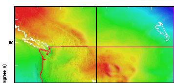
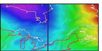
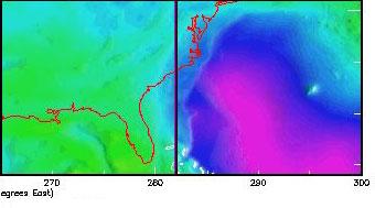
Graphical Interface - click on the desired image grid to download a binary file
Non-Graphical Interface
Conterminous United States
- Binary Grids (all are 1141 columns by 1081 rows and are 4,933,728 bytes in size)
Disclaimer
|
For more information contact NGS Information
Services:
by email,
or call (301) 713-3242, Monday-Friday, 7:00 AM - 4:30 PM eastern time.
For questions about this page or downloading
problems,
contact the
Webmaster.
|
|
http://www.ngs.noaa.gov/PC_PROD/G99SSS/index.shtml |
Last Modified:
May 16, 2017. |
|
|
|
|