| PID:
|
UW7919 |
| Designation:
|
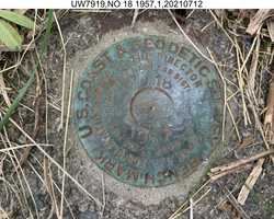
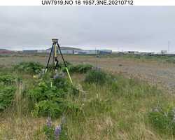
TIDAL BENCH MARK 18 |
| Stamping:
|
|
| Stability:
|
May hold commonly subject to ground movement |
| Setting:
|
Mat foundation or concrete slab other than pavement |
| Mark Condition:
|
G |
| Description:
|
The fireplug in the original description has been removed. The station is 125 m (410 ft) south of the administration building flag pole, 25 m (82.0 ft) northwest of the rip rap edge, 2.1 m (6.9 ft) south of a sewer hole cover, and 0.3 m (1.0 ft) east of the NOS witness post. |
| Observed:
|
2021-07-13T07:53:00Z |
more obs 2016-10-14
|
| Source:
|
OPUS - page5 2008.25 |
|
|
|
| Close-up View
|
|
| REF_FRAME:
NAD_83(2011) |
EPOCH:
2010.0000 |
SOURCE:
NAVD88 (Computed using GEOID12B) |
UNITS:
m |
SET PROFILE
|
DETAILS
|
|
| LAT:
|
51° 51' 41.09803"
|
± 0.010
m |
| LON:
|
-176° 38' 28.09853"
|
±
0.010
m |
| ELL HT:
|
11.501 |
±
0.004
m |
| X:
|
-3940326.422 |
±
0.007
m |
| Y:
|
-231259.497 |
±
0.010
m |
| Z:
|
4993304.403 |
±
0.009
m |
| ORTHO HT:
|
5.484 |
±
0.353
m |
|
|
UTM
1 |
SPC
5010(AK10) |
| NORTHING:
|
5745685.570m |
96049.893m |
| EASTING:
|
524712.003m |
955832.996m |
| CONVERGENCE:
|
0.28225278°
|
-0.51093889°
|
| POINT SCALE:
|
0.99960750 |
0.99999165 |
| COMBINED FACTOR:
|
0.99960570 |
0.99998985 |
|
|
|
|
| Horizon View
|
|
|
|
|