| PID:
|
LX7598 |
| Designation:
|
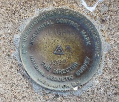
LIGHT |
| Stamping:
|
LIGHT 1982 |
| Stability:
|
May hold commonly subject to ground movement |
| Setting:
|
Mat foundation or concrete slab other than pavement |
| Mark Condition:
|
G |
| Description:
|
The bench mark is a disk set flush in a 1.3 m x 2.3 m (4.3 ft x 7.5 ft) concrete slab north of the lighthouse at Lighthouse Point Park, on high ground and near the shoreline, 39.44 m (129.4 ft) WNW of the west corner of a picnic pavilion, 37.70 m (123.7 ft) SW of a 2 m (7 ft) circumference oak tree, and 10.70 m (35.1 ft) west of the centerline of a track road. |
| Observed:
|
2022-07-31T19:04:00Z |
more obs 2022-09-19
|
| Source:
|
OPUS - page5 2008.25 |
|
|
|
| Close-up View
|
|
| REF_FRAME:
NAD_83(2011) |
EPOCH:
2010.0000 |
SOURCE:
NAVD88 (Computed using GEOID18) |
UNITS:
m |
SET PROFILE
|
DETAILS
|
|
| LAT:
|
41° 15' 0.68972"
|
± 0.006
m |
| LON:
|
-72° 54' 13.87958"
|
±
0.009
m |
| ELL HT:
|
-23.956 |
±
0.017
m |
| X:
|
1411760.531 |
±
0.007
m |
| Y:
|
-4590098.314 |
±
0.013
m |
| Z:
|
4183337.416 |
±
0.014
m |
| ORTHO HT:
|
5.991 |
±
0.062
m |
|
|
UTM
18 |
SPC
600(CT) |
| NORTHING:
|
4568650.038m |
198706.876m |
| EASTING:
|
675625.857m |
291905.093m |
| CONVERGENCE:
|
1.38244167°
|
-0.10201667°
|
| POINT SCALE:
|
0.99997962 |
0.99999531 |
| COMBINED FACTOR:
|
0.99998338 |
0.99999907 |
|
|
|
|
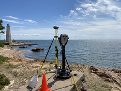
| Horizon View
|
|
|
|
|