| PID:
|
LX3418 |
| Designation:
|
846 1490 K TIDAL |
| Stamping:
|
1490 K 1979 |
| Stability:
|
Most reliable; expected to hold position well |
| Setting:
|
In rock outcrop or ledge |
| Mark Condition:
|
G |
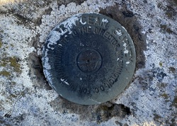
| Description:
|
The bench mark is a disk set in bedrock, located 0.2 km (0.1 mi) west along State Pier Road from the junction of Winthrop Street, 22.43m (73.6 ft) West of the power poles #123/64 concrete support, 10.39 m (34.1 ft) NNW of the centerline of State Pier Road, 7.78m (25.5 ft) SSE of the South rail of the southernmost track, and 0.30 m (0.98 ft) above ground. |
| Observed:
|
2022-08-10T12:08:00Z |
more obs 2022-09-30
|
| Source:
|
OPUS - page5 2008.25 |
|
|
|
| Close-up View
|
|
| REF_FRAME:
NAD_83(2011) |
EPOCH:
2010.0000 |
SOURCE:
NAVD88 (Computed using GEOID18) |
UNITS:
m |
SET PROFILE
|
DETAILS
|
|
| LAT:
|
41° 21' 42.99721"
|
± 0.010
m |
| LON:
|
-72° 5' 41.02148"
|
±
0.008
m |
| ELL HT:
|
-21.725 |
±
0.017
m |
| X:
|
1473920.499 |
±
0.011
m |
| Y:
|
-4561910.529 |
±
0.009
m |
| Z:
|
4192662.050 |
±
0.012
m |
| ORTHO HT:
|
8.838 |
±
0.057
m |
|
|
UTM
18 |
SPC
600(CT) |
| NORTHING:
|
4583010.711m |
211314.337m |
| EASTING:
|
743009.672m |
359628.127m |
| CONVERGENCE:
|
1.92078056°
|
0.43448333°
|
| POINT SCALE:
|
1.00032682 |
0.99998761 |
| COMBINED FACTOR:
|
1.00033023 |
0.99999102 |
|
|
|
|
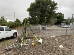
| Horizon View
|
|
|
|
|