| PID:
|
LX1428 |
| Designation:
|
TIDAL 1 M STA I 12 |
| Stamping:
|
1 M 1934 |
| Stability:
|
Most reliable; expected to hold position well |
| Setting:
|
In rock outcrop or ledge |
| Mark Condition:
|
G |
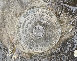
| Description:
|
The primary bench mark is a disk set in exposed bedrock on the bank of the river, 41.75 m (137.0 ft) S of bench mark hyde park 2 reset, 18.30 m (60.0 ft) SSW of a 0.4 m (1.3 ft) diameter sycamore tree, 15.60 m (51.2 ft) W of the center of a gate in the fence along the W side of the railroad tracks and 15.20 m (49.9 ft) W of the fence. |
| Observed:
|
2022-06-04T11:07:00Z |
more obs 2022-07-01
|
| Source:
|
OPUS - page5 2008.25 |
|
|
|
| Close-up View
|
|
| REF_FRAME:
NAD_83(2011) |
EPOCH:
2010.0000 |
SOURCE:
NAVD88 (Computed using GEOID18) |
UNITS:
m |
SET PROFILE
|
DETAILS
|
|
| LAT:
|
41° 47' 18.03746"
|
± 0.003
m |
| LON:
|
-73° 56' 49.25324"
|
±
0.001
m |
| ELL HT:
|
-30.566 |
±
0.008
m |
| X:
|
1317004.163 |
±
0.001
m |
| Y:
|
-4576960.519 |
±
0.004
m |
| Z:
|
4228083.919 |
±
0.006
m |
| ORTHO HT:
|
1.155 |
±
0.054
m |
|
|
UTM
18 |
SPC
3101(NY E) |
| NORTHING:
|
4626812.504m |
328241.282m |
| EASTING:
|
587494.679m |
195962.241m |
| CONVERGENCE:
|
0.70173333°
|
0.36850556°
|
| POINT SCALE:
|
0.99969420 |
0.99992599 |
| COMBINED FACTOR:
|
0.99969899 |
0.99993078 |
|
|
|
|
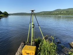
| Horizon View
|
|
|
|
|