| PID:
|
LW2264 |
| Designation:
|
STATE |
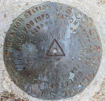
| Stamping:
|
STATE 1955 |
| Stability:
|
Monument will probably hold position well |
| Setting:
|
Abutment or pier of large bridges |
| Mark Condition:
|
G |
| Description:
|
The primary bench mark is a USC&GS survey disk located near the NW corner of the pier, 10.60 m (34.8 ft) NW of the NW corner of the State Pier warehouse, 5.90 m (19.4 ft) SSE of the NW corner of the pier, 1.33 m (4.4 ft) east of the west side of the pier, and 1.26 m (4.1 ft) west of the center of railroad tracks. |
| Observed:
|
2021-06-02T16:08:00Z |
more obs 2021-06-25
|
| Source:
|
OPUS - page5 2008.25 |
|
|
|
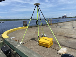
| Close-up View
|
|
| REF_FRAME:
NAD_83(2011) |
EPOCH:
2010.0000 |
SOURCE:
NAVD88 (Computed using GEOID18) |
UNITS:
m |
SET PROFILE
|
DETAILS
|
|
| LAT:
|
41° 42' 20.34292"
|
± 0.006
m |
| LON:
|
-71° 9' 54.71068"
|
±
0.003
m |
| ELL HT:
|
-26.558 |
±
0.022
m |
| X:
|
1539560.180 |
±
0.008
m |
| Y:
|
-4513439.898 |
±
0.019
m |
| Z:
|
4221234.083 |
±
0.010
m |
| ORTHO HT:
|
2.918 |
±
0.060
m |
|
|
UTM
19 |
SPC
2001(MA M) |
| NORTHING:
|
4619360.970m |
828431.007m |
| EASTING:
|
319854.493m |
227866.090m |
| CONVERGENCE:
|
-1.44090000°
|
0.22489722°
|
| POINT SCALE:
|
0.99999936 |
1.00000163 |
| COMBINED FACTOR:
|
1.00000353 |
1.00000580 |
|
|
|
|
| Horizon View
|
|
|
|
|