| PID:
|
LW0810 |
| Designation:
|
845 8694 TIDAL 1 |
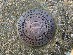
| Stamping:
|
BM NO 1 1939 |
| Stability:
|
Monuments of questionable or unknown reliability |
| Setting:
|
Pavement (street sidewalk curb etc.) |
| Mark Condition:
|
G |
| Description:
|
Bench mark recovered in good condition 30.72 m (100.79 ft) E of the end of a NE-SW running stone wall, 26.33 m (86.38 ft) W of a stone pillar at the N end of a N-S running stone wall, 17.71 m (58.1 ft) S of the inside N corner of the old garage foundation, and 10.84 m (35.56 ft) NE of the N corner of the bottom step of a concrete staircase. |
| Observed:
|
2022-06-15T13:55:00Z |
more obs 2022-07-05
|
| Source:
|
OPUS - page5 2008.25 |
|
|
|
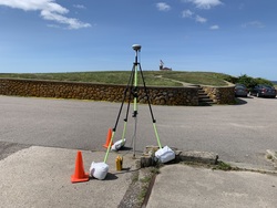
| Close-up View
|
|
| REF_FRAME:
NAD_83(2011) |
EPOCH:
2010.0000 |
SOURCE:
NAVD88 (Computed using GEOID18) |
UNITS:
m |
SET PROFILE
|
DETAILS
|
|
| LAT:
|
41° 18' 20.28895"
|
± 0.011
m |
| LON:
|
-71° 51' 27.35590"
|
±
0.013
m |
| ELL HT:
|
-28.046 |
±
0.004
m |
| X:
|
1494072.703 |
±
0.009
m |
| Y:
|
-4559691.664 |
±
0.013
m |
| Z:
|
4187962.246 |
±
0.005
m |
| ORTHO HT:
|
2.661 |
±
0.051
m |
|
|
UTM
19 |
SPC
3800(RI) |
| NORTHING:
|
4576625.993m |
24749.929m |
| EASTING:
|
260772.219m |
70052.926m |
| CONVERGENCE:
|
-1.88712500°
|
-0.23604444°
|
| POINT SCALE:
|
1.00030438 |
1.00000478 |
| COMBINED FACTOR:
|
1.00030878 |
1.00000918 |
|
|
|
|
| Horizon View
|
|
|
|
|