| PID:
|
LW0711 |
| Designation:
|
V 37 |
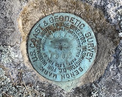
| Stamping:
|
V 37 1965 |
| Stability:
|
Most reliable; expected to hold position well |
| Setting:
|
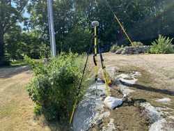
In rock outcrop or ledge |
| Mark Condition:
|
G |
| Description:
|
The bench mark is a disk set in bedrock, 25.30 m (83.0 ft) NNW of center of a catch basin W of residence driveway on Noank road, 24.35 m (79.9 ft) S of a utility pole in the residence front yard, 23.76 m (78.0 ft) NNW of a fire hydrant, 9.45 m (31.0 ft) W of the centerline of the residence driveway perpendicular to the rock formation and 3.99 m (13.1 ft) ENE of a utility pole just W of the bedrock. |
| Observed:
|
2022-08-10T18:20:00Z |
more obs 2022-10-03
|
| Source:
|
OPUS - page5 2008.25 |
|
|
|
| Close-up View
|
|
| REF_FRAME:
NAD_83(2011) |
EPOCH:
2010.0000 |
SOURCE:
NAVD88 (Computed using GEOID18) |
UNITS:
m |
SET PROFILE
|
DETAILS
|
|
| LAT:
|
41° 20' 31.27700"
|
± 0.008
m |
| LON:
|
-71° 58' 57.76320"
|
±
0.018
m |
| ELL HT:
|
-21.863 |
±
0.020
m |
| X:
|
1483288.558 |
±
0.015
m |
| Y:
|
-4560410.253 |
±
0.016
m |
| Z:
|
4191001.056 |
±
0.018
m |
| ORTHO HT:
|
8.787 |
±
0.058
m |
|
|
UTM
19 |
SPC
600(CT) |
| NORTHING:
|
4581018.784m |
209179.016m |
| EASTING:
|
250436.000m |
369020.097m |
| CONVERGENCE:
|
-1.97125278°
|
0.50875833°
|
| POINT SCALE:
|
1.00036656 |
0.99998871 |
| COMBINED FACTOR:
|
1.00036999 |
0.99999214 |
|
|
|
|
| Horizon View
|
|
|
|
|