| PID:
|
KV5987 |
| Designation:
|
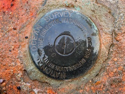
853 9487 A TIDAL |
| Stamping:
|
9487 A 1976 |
| Stability:
|
May hold commonly subject to ground movement |
| Setting:
|
Footings of small/medium structures |
| Mark Condition:
|
G |
| Description:
|
The primary bench mark is a disk set in the NE corner of a concrete footing, 28.71 m (94.2 ft) east of the SW corner of a steel chain link fence bordering the river, 26.46 m (86.8 ft) SW of the south end of a propane gas storage tank, 19.26 m (63.2 ft) NW of the SW corner of the brick building, and 14.36 m (47.1 ft) west of the NW corner of a one-story brick storage building. |
| Observed:
|
2021-10-28T12:12:00Z |
more obs 2021-11-22
|
| Source:
|
OPUS - page5 2008.25 |
|
|
|
| Close-up View
|
|
| REF_FRAME:
NAD_83(2011) |
EPOCH:
2010.0000 |
SOURCE:
NAVD88 (Computed using GEOID18) |
UNITS:
m |
SET PROFILE
|
DETAILS
|
|
| LAT:
|
40° 8' 6.94471"
|
± 0.005
m |
| LON:
|
-74° 44' 12.31195"
|
±
0.003
m |
| ELL HT:
|
-29.735 |
±
0.018
m |
| X:
|
1285475.121 |
±
0.005
m |
| Y:
|
-4710776.095 |
±
0.011
m |
| Z:
|
4089460.212 |
±
0.015
m |
| ORTHO HT:
|
3.083 |
±
0.053
m |
|
|
UTM
18 |
SPC
2900(NJ) |
| NORTHING:
|
4442803.409m |
144558.764m |
| EASTING:
|
522426.271m |
129824.676m |
| CONVERGENCE:
|
0.16968889°
|
-0.15261111°
|
| POINT SCALE:
|
0.99960619 |
0.99990501 |
| COMBINED FACTOR:
|
0.99961085 |
0.99990967 |
|
|
|
|
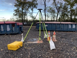
| Horizon View
|
|
|
|
|