| PID:
|
JU2431 |
| Designation:
|
853 4212 F TIDAL |
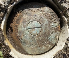
| Stamping:
|
4212 F 1977 |
| Stability:
|
Monument will probably hold position well |
| Setting:
|
Copper-clad steel rod without sleeve (10FT+ or 3.048M+) |
| Mark Condition:
|
G |
| Description:
|
The bench mark is a disk located 61 m (200 ft) NE of Bench Mark F 8 1930 8.333, 31 m (101 ft) SW of wood utility pole #14605, 24.17 m (79.3 ft) NW of wood utility pole #14604, and 4.39 m (14.4 ft) west of the centerline of the bituminous paved road bordering the east side of a triangular park. The bench mark is 0.06 m (0.2 ft) below ground level, crimped to a copper-clad steel rod driven 15.2 m (50), and encased in a PVC pipe and concrete kickblock. |
| Observed:
|
2022-04-07T13:14:00Z |
more obs 2022-04-25
|
| Source:
|
OPUS - page5 2008.25 |
|
|
|
| Close-up View
|
|
| REF_FRAME:
NAD_83(2011) |
EPOCH:
2010.0000 |
SOURCE:
NAVD88 (Computed using GEOID18) |
UNITS:
m |
SET PROFILE
|
DETAILS
|
|
| LAT:
|
39° 32' 42.50548"
|
± 0.007
m |
| LON:
|
-74° 27' 40.72007"
|
±
0.012
m |
| ELL HT:
|
-31.818 |
±
0.019
m |
| X:
|
1319351.200 |
±
0.012
m |
| Y:
|
-4744982.445 |
±
0.016
m |
| Z:
|
4039149.184 |
±
0.014
m |
| ORTHO HT:
|
1.776 |
±
0.056
m |
|
|
UTM
18 |
SPC
2900(NJ) |
| NORTHING:
|
4377412.776m |
79016.992m |
| EASTING:
|
546286.094m |
153325.276m |
| CONVERGENCE:
|
0.34298056°
|
0.02463333°
|
| POINT SCALE:
|
0.99962638 |
0.99990014 |
| COMBINED FACTOR:
|
0.99963137 |
0.99990513 |
|
|
|
|
| Horizon View
|
|
|
|
|