| PID:
|
JU2400 |
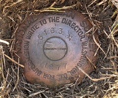
| Designation:
|
853 5163 A TIDAL |
| Stamping:
|
5163 A 1977 |
| Stability:
|
Monument will probably hold position well |
| Setting:
|
Galvanized steel rod without sleeve (10FT+ or 3.048M+) |
| Mark Condition:
|
G |
| Description:
|
The BM is a disk located at the intersection of Commonwealth Ave and Whittier Rd, 15m (49ft) SW of wood utility pole #291, 12.13m (39.8ft) NE of wood utility pole #3651 on the north edge of Whittier Road, 6.28m (20.6ft) east of the SE corner of house #101 Whittier Rd (a 2-story frame house), and 3.17m (10.4ft) NW of the NW curb of Commonwealth Ave. The BM is set 6cm (0.2ft) below ground level, crimped to the top of a galvanized steel rod driven 50ft, and encased in a PVC pipe & conc. kickblock. |
| Observed:
|
2022-02-15T13:57:00Z |
more obs 2022-03-10
|
| Source:
|
OPUS - page5 2008.25 |
|
|
|
| Close-up View
|
|
| REF_FRAME:
NAD_83(2011) |
EPOCH:
2010.0000 |
SOURCE:
NAVD88 (Computed using GEOID18) |
UNITS:
m |
SET PROFILE
|
DETAILS
|
|
| LAT:
|
39° 11' 56.25136"
|
± 0.004
m |
| LON:
|
-74° 39' 19.21331"
|
±
0.004
m |
| ELL HT:
|
-33.526 |
±
0.018
m |
| X:
|
1309726.657 |
±
0.003
m |
| Y:
|
-4772933.236 |
±
0.011
m |
| Z:
|
4009437.168 |
±
0.014
m |
| ORTHO HT:
|
1.347 |
±
0.053
m |
|
|
UTM
18 |
SPC
2900(NJ) |
| NORTHING:
|
4338912.198m |
40597.626m |
| EASTING:
|
529761.244m |
136582.817m |
| CONVERGENCE:
|
0.21783333°
|
-0.09817500°
|
| POINT SCALE:
|
0.99961091 |
0.99990222 |
| COMBINED FACTOR:
|
0.99961617 |
0.99990748 |
|
|
|
|
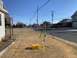
| Horizon View
|
|
|
|
|