| PID:
|
JU1833 |
| Designation:
|
U 2 |
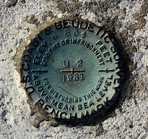
| Stamping:
|
6.834 U 2 1931 |
| Stability:
|
May hold commonly subject to ground movement |
| Setting:
|
Set in top of concrete monument |
| Mark Condition:
|
G |
| Description:
|
The bench mark is a disk set in a 0.24 m (0.8 ft) square concrete monument located south of the COE administration building, 14.57 m (47.8 ft) south of the west concrete wall for the steps leading to the basement of the administration building, 10.27m (33.7 ft) North of the centerline of the main road, 8.56m (28.1 ft) West of the West edge of a sidewalk leading to the administrative building, and 0.15m (0.5 ft) above the ground. |
| Observed:
|
2021-11-08T13:28:00Z |
more obs 2021-11-26
|
| Source:
|
OPUS - page5 2008.25 |
|
|
|
| Close-up View
|
|
| REF_FRAME:
NAD_83(2011) |
EPOCH:
2010.0000 |
SOURCE:
NAVD88 (Computed using GEOID18) |
UNITS:
m |
SET PROFILE
|
DETAILS
|
|
| LAT:
|
39° 31' 37.74054"
|
± 0.020
m |
| LON:
|
-75° 48' 26.02040"
|
±
0.012
m |
| ELL HT:
|
-31.674 |
±
0.020
m |
| X:
|
1207846.361 |
±
0.011
m |
| Y:
|
-4775895.696 |
±
0.004
m |
| Z:
|
4037608.856 |
±
0.028
m |
| ORTHO HT:
|
1.649 |
±
0.063
m |
|
|
UTM
18 |
SPC
1900(MD) |
| NORTHING:
|
4375588.714m |
207199.286m |
| EASTING:
|
430621.911m |
502553.040m |
| CONVERGENCE:
|
-0.51377500°
|
0.74862500°
|
| POINT SCALE:
|
0.99965926 |
1.00001441 |
| COMBINED FACTOR:
|
0.99966423 |
1.00001938 |
|
|
|
|
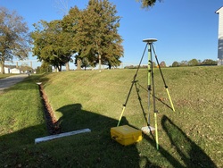
| Horizon View
|
|
|
|
|