| PID:
|
JU0125 |
| Designation:
|
B 55 |
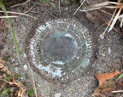
| Stamping:
|
B 55 1961 |
| Stability:
|
May hold commonly subject to ground movement |
| Setting:
|
Set in top of concrete monument |
| Mark Condition:
|
G |
| Description:
|
The bench mark is a disk located 1.05 km (0.65 mi) SE on Westecunk Creek Dock Road from the intersection with U.S. Highway 9 in West Creek, 9.75 m (32.0 ft) NW of the centerline of a driveway leading to Creston Court, 9 m (30 ft) SW of the centerline of Westecunk Creek Dock Road, 1.98 m (6.5 ft) NW of a cable line pole, 0.30 m (1.0 ft) below road surface, and set into the top of a concrete post. |
| Observed:
|
2022-04-19T12:47:00Z |
more obs 2022-05-13
|
| Source:
|
OPUS - page5 2008.25 |
|
|
|
| Close-up View
|
|
| REF_FRAME:
NAD_83(2011) |
EPOCH:
2010.0000 |
SOURCE:
NAVD88 (Computed using GEOID18) |
UNITS:
m |
SET PROFILE
|
DETAILS
|
|
| LAT:
|
39° 37' 51.35052"
|
± 0.002
m |
| LON:
|
-74° 17' 47.24578"
|
±
0.005
m |
| ELL HT:
|
-32.413 |
±
0.020
m |
| X:
|
1331355.189 |
±
0.006
m |
| Y:
|
-4735322.922 |
±
0.014
m |
| Z:
|
4046489.184 |
±
0.014
m |
| ORTHO HT:
|
1.013 |
±
0.057
m |
|
|
UTM
18 |
SPC
2900(NJ) |
| NORTHING:
|
4387031.888m |
88560.136m |
| EASTING:
|
560376.555m |
167472.781m |
| CONVERGENCE:
|
0.44876111°
|
0.12982778°
|
| POINT SCALE:
|
0.99964488 |
0.99990376 |
| COMBINED FACTOR:
|
0.99964996 |
0.99990884 |
|
|
|
|
| Horizon View
|
|
|
|
|