| PID:
|
JT2895 |
| Designation:
|
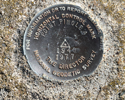
POINT PINOLE 4 RESET |
| Stamping:
|
POINT PINOLE 4 1940 1977 |
| Stability:
|
May hold commonly subject to ground movement |
| Setting:
|
Set in top of concrete monument |
| Mark Condition:
|
G |
| Description:
|
The bench mark is 32.71m (107.3ft) NW of Middle of Bay View gravel trail, 14.02m (46.0ft) south of Pinole Point 4 reference mark, 6.23m (20.4ft) west of a wooden fence, 4.84m (15.9ft) NW of north edge of Warning Steep Cliff sign, and 1.05m (3.4ft) NE of a witness post. |
| Observed:
|
2022-02-22T18:54:00Z |
more obs 2022-04-05
|
| Source:
|
OPUS - page5 2008.25 |
|
|
|
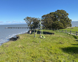
| Close-up View
|
|
| REF_FRAME:
NAD_83(2011) |
EPOCH:
2010.0000 |
SOURCE:
NAVD88 (Computed using GEOID18) |
UNITS:
m |
SET PROFILE
|
DETAILS
|
|
| LAT:
|
38° 0' 41.88208"
|
± 0.008
m |
| LON:
|
-122° 22' 0.22703"
|
±
0.004
m |
| ELL HT:
|
-11.371 |
±
0.011
m |
| X:
|
-2693612.263 |
±
0.008
m |
| Y:
|
-4249906.533 |
±
0.006
m |
| Z:
|
3906454.462 |
±
0.011
m |
| ORTHO HT:
|
20.900 |
±
0.042
m |
|
|
UTM
10 |
SPC
403(CA 3) |
| NORTHING:
|
4207295.021m |
669398.837m |
| EASTING:
|
555590.929m |
1836087.229m |
| CONVERGENCE:
|
0.38999167°
|
-1.14287222°
|
| POINT SCALE:
|
0.99963806 |
0.99993949 |
| COMBINED FACTOR:
|
0.99963984 |
0.99994127 |
|
|
|
|
| Horizon View
|
|
|
|
|