| PID:
|
HV0238 |
| Designation:
|
857 1892 4 |
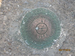
| Stamping:
|
NO 4 1942 |
| Stability:
|
May hold commonly subject to ground movement |
| Setting:
|
Mat foundation or concrete slab other than pavement |
| Mark Condition:
|
G |
| Description:
|
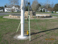
The bench mark is a disk set in the west side of a 2.13 m (7.0 ft) diameter concrete flagpole foundation located 0.5 km (0.3 mi)NE along High Street from the Dorchester County Courthouse, 12.41 m (40.7 ft) NW of the NW curb of the drive on the SE side of the circle drive at the end of High Street, 11.80 m(38.7 ft) SE of the SE curb of the drive on the NW side of the circle drive,8.05 m (26.4 ft) NE of the NE edge of a walkway on the NE side of a pool of water, 0.3 m (1 ft) west of the flagpole. |
| Observed:
|
2014-04-17T12:56:00Z |
more obs 2009-02-18
|
| Source:
|
OPUS - page5 1209.04 |
|
|
|
| Close-up View
|
|
| REF_FRAME:
NAD_83(2011) |
EPOCH:
2010.0000 |
SOURCE:
NAVD88 (Computed using GEOID18) |
UNITS:
m |
SET PROFILE
|
DETAILS
|
|
| LAT:
|
38° 34' 31.32696"
|
± 0.003
m |
| LON:
|
-76° 4' 19.52263"
|
±
0.004
m |
| ELL HT:
|
-33.867 |
±
0.017
m |
| X:
|
1201778.642 |
±
0.004
m |
| Y:
|
-4846037.854 |
±
0.015
m |
| Z:
|
3955552.476 |
±
0.008
m |
| ORTHO HT:
|
1.164 |
±
0.056
m |
|
|
UTM
18 |
SPC
1900(MD ) |
| NORTHING:
|
4270201.331m |
101280.403m |
| EASTING:
|
406612.335m |
480855.430m |
| CONVERGENCE:
|
-0.66854286°
|
0.58238823°
|
| POINT SCALE:
|
0.99970740 |
0.99996352 |
| COMBINED FACTOR:
|
0.99971271 |
0.99996883 |
|
|
|
|
| Horizon View
|
|
|
|
|