| PID:
|
HT0024 |
| Designation:
|
43 A |
| Stamping:
|
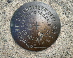
43 A 1941 HARBOR LINE |
| Stability:
|
Monuments of questionable or unknown reliability |
| Setting:
|
Pavement (street sidewalk curb etc.) |
| Mark Condition:
|
G |
| Description:
|
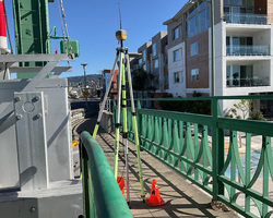
The bench mark is a disk set in top of the NE sidewalk of the Park Street bridge over the channel, about 46 m (150 ft) SW of the Y-junction of 29th and 23rd Avenues in Oakland, 3.05m (10.0ft) south of a USACE brass disk stamped TC 423 1981, 2.87 m (9.4 ft) east of the east corner of the drawspan, and 1.04 m (3.4 ft) NW of the SE steel guardrail. |
| Observed:
|
2022-02-15T18:22:00Z |
more obs 2018-09-25
|
| Source:
|
OPUS - page5 2008.25 |
|
|

|
| Close-up View
|
|
| REF_FRAME:
NAD_83(2011) |
EPOCH:
2010.0000 |
SOURCE:
NAVD88 (Computed using GEOID18) |
UNITS:
m |
SET PROFILE
|
DETAILS
|
|
| LAT:
|
37° 46' 19.56349"
|
± 0.003
m |
| LON:
|
-122° 14' 9.89290"
|
±
0.007
m |
| ELL HT:
|
-26.000 |
±
0.006
m |
| X:
|
-2692618.244 |
±
0.004
m |
| Y:
|
-4269839.690 |
±
0.006
m |
| Z:
|
3885463.999 |
±
0.005
m |
| ORTHO HT:
|
6.411 |
±
0.054
m |
|
|
UTM
10 |
SPC
403(CA 3) |
| NORTHING:
|
4180804.367m |
642597.550m |
| EASTING:
|
567277.546m |
1847064.617m |
| CONVERGENCE:
|
0.46793333°
|
-1.06288333°
|
| POINT SCALE:
|
0.99965575 |
0.99992925 |
| COMBINED FACTOR:
|
0.99965983 |
0.99993333 |
|
|
|

|
| Horizon View
|
|
|
|
|