| PID:
|
DY2123 |
| Designation:
|
TIDAL 4 |
| Stamping:
|
4 1936 |
| Stability:
|
Most reliable; expected to hold position well |
| Setting:
|
In rock outcrop or ledge |
| Mark Condition:
|
G |
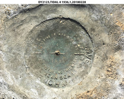
| Description:
|
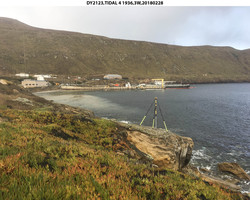
The mark is a USCGS disk set in a bedrock outcrop ledge along the shoreline of Wilson Cove, 212 m (695.5 ft) east of the base of the pier, 184 m (603.7 ft) east of the NE corner of the pier, 25.58 m (83.9 ft) ENE of Tidal 3, 4.55 m (14.9 ft) ESE of the seaward edge of the rock outcrop, 2.90 m (9.5 ft) north of the edge of low scrub vegetation, 1.10 m (3.6 ft) WSW of the NE side of the rock ledge where it drops off to a rock gully, and about 0.02 m (0.1 ft) higher than the rock. |
| Observed:
|
2018-02-27T16:16:00Z |
more obs 1952
|
| Source:
|
OPUS - page5 1603.24 |
|
|
|
| Close-up View
|
|
| REF_FRAME:
NAD_83(2011) |
EPOCH:
2010.0000 |
SOURCE:
NAVD88 (Computed using GEOID18) |
UNITS:
m |
SET PROFILE
|
DETAILS
|
|
| LAT:
|
33° 0' 18.72688"
|
± 0.010
m |
| LON:
|
-118° 33' 18.85666"
|
±
0.005
m |
| ELL HT:
|
-31.704 |
±
0.008
m |
| X:
|
-2559307.048 |
±
0.007
m |
| Y:
|
-4702839.352 |
±
0.006
m |
| Z:
|
3454425.199 |
±
0.011
m |
| ORTHO HT:
|
5.479 |
±
0.076
m |
|
|
UTM
11 |
SPC
405(CA 5) |
| NORTHING:
|
3652937.846m |
445251.349m |
| EASTING:
|
354717.364m |
1948094.761m |
| CONVERGENCE:
|
-0.84731016°
|
-0.31649224°
|
| POINT SCALE:
|
0.99986025 |
1.00038114 |
| COMBINED FACTOR:
|
0.99986523 |
1.00038612 |
|
|
|
|
| Horizon View
|
|
|
|
|