| PID:
|
DY2122 |
| Designation:
|
TIDAL 3 |
| Stamping:
|
NO 3 1933 |
| Stability:
|
Most reliable; expected to hold position well |
| Setting:
|
In rock outcrop or ledge |
| Mark Condition:
|
P |
| Description:
|
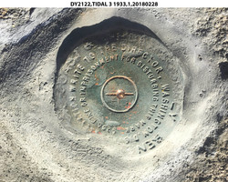
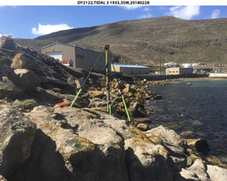
The mark is a USCGS disk set in bedrock outcrop along the shore of Wilson Cove, 188 m (616.8 ft) east of the base of the concrete pier, 165 m (541.3 ft) east of the side of the pier, 57.5 m (188.6 ft) NNE of building 60178, 25.58 m (83.9 ft) WSW of Tidal 4, 4.60 m (15.1 ft) SSE of the seaward edge of the rock, 3.30 m (10.8 ft) WNW of the edge of low scrub vegetation, and about 0.02 m (0.1 ft) higher than the rock. Note: disk is slanted and edges are bent, but secure and new cement was applied. |
| Observed:
|
2018-02-28T18:34:00Z |
more obs 1952
|
| Source:
|
OPUS - page5 1603.24 |
|
|
|
| Close-up View
|
|
| REF_FRAME:
NAD_83(2011) |
EPOCH:
2010.0000 |
SOURCE:
NAVD88 (Computed using GEOID18) |
UNITS:
m |
SET PROFILE
|
DETAILS
|
|
| LAT:
|
33° 0' 18.44082"
|
± 0.015
m |
| LON:
|
-118° 33' 19.77966"
|
±
0.007
m |
| ELL HT:
|
-32.681 |
±
0.003
m |
| X:
|
-2559329.995 |
±
0.007
m |
| Y:
|
-4702831.396 |
±
0.010
m |
| Z:
|
3454417.276 |
±
0.012
m |
| ORTHO HT:
|
4.501 |
±
0.078
m |
|
|
UTM
11 |
SPC
405(CA 5) |
| NORTHING:
|
3652929.390m |
445242.666m |
| EASTING:
|
354693.281m |
1948070.745m |
| CONVERGENCE:
|
-0.84744808°
|
-0.31663839°
|
| POINT SCALE:
|
0.99986034 |
1.00038118 |
| COMBINED FACTOR:
|
0.99986547 |
1.00038631 |
|
|
|
|
| Horizon View
|
|
|
|
|