| PID:
|
DP8228 |
| Designation:
|
872 9905 G |
| Stamping:
|
9905 G 2006 |
| Stability:
|
Monument will probably hold position well |
| Setting:
|
Abutment or pier of large bridges |
| Mark Condition:
|
G |
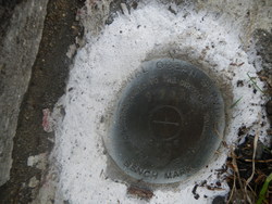
| Description:
|
The bench mark is a disk set in the top of the NE concrete abutment of the Millview Bayou Bridge # 480022, 241.7 Ft ENE of bench mark DOT, 65.0 Ft south of Perdido Bay mean high water line, 23.2 Ft north of the centerline of Lillian Highway, 0.3 Ft east of the east edge of the northern most concrete guard rail of the bridge. |
| Observed:
|
2020-01-16T18:34:00Z |
more obs 2020-01-29
|
| Source:
|
OPUS - page5 1801.18 |
|
|
|
| Close-up View
|
|
| REF_FRAME:
NAD_83(2011) |
EPOCH:
2010.0000 |
SOURCE:
NAVD88 (Computed using GEOID18) |
UNITS:
m |
SET PROFILE
|
DETAILS
|
|
| LAT:
|
30° 25' 16.45392"
|
± 0.006
m |
| LON:
|
-87° 20' 58.98217"
|
±
0.006
m |
| ELL HT:
|
-25.116 |
±
0.011
m |
| X:
|
254537.257 |
±
0.006
m |
| Y:
|
-5498850.188 |
±
0.008
m |
| Z:
|
3210715.329 |
±
0.010
m |
| ORTHO HT:
|
2.440 |
±
0.053
m |
|
|
UTM
16 |
SPC
903(FL N) |
| NORTHING:
|
3365515.248m |
160962.839m |
| EASTING:
|
466413.837m |
326249.983m |
| CONVERGENCE:
|
-0.17708333°
|
-1.43205556°
|
| POINT SCALE:
|
0.99961392 |
0.99995822 |
| COMBINED FACTOR:
|
0.99961786 |
0.99996216 |
|
|
|
|
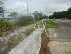
| Horizon View
|
|
|
|
|