| PID:
|
DM4811 |
| Designation:
|
872 8488 D |
| Stamping:
|
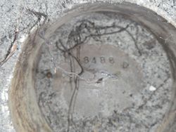
8488 D 1977 |
| Stability:
|
Monument will probably hold position well |
| Setting:
|
Copper-clad rod in sleeve (10FT+ or 3.048M+) |
| Mark Condition:
|
G |
| Description:
|
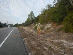
The primary bench mark is a disk located about 305.0 ft NE of a CGS bench mark stamped S 293 1967, 285.0 ft SW of bench mark 8488 E 2007, 50.0 ft SW of wooden power pole #7129302 with three guy wires attached, 60 FT N of a mail box, and 1.0 ft SE of a metal witness post. The bench mark is set about 2.0 ft below the level of U.S. Highway 98, crimped to the top of a copper clad steel rod driven into the ground and encased in a PVC pipe. |
| Observed:
|
2016-12-08T13:19:00Z |
more obs 2007-02-07
|
| Source:
|
OPUS - page5 1209.04 |
|
|

|
| Close-up View
|
|
| REF_FRAME:
NAD_83(2011) |
EPOCH:
2010.0000 |
SOURCE:
NAVD88 (Computed using GEOID18) |
UNITS:
m |
SET PROFILE
|
DETAILS
|
|
| LAT:
|
29° 48' 3.15577"
|
± 0.007
m |
| LON:
|
-84° 44' 28.75615"
|
±
0.006
m |
| ELL HT:
|
-20.895 |
±
0.029
m |
| X:
|
507685.115 |
±
0.009
m |
| Y:
|
-5515927.401 |
±
0.024
m |
| Z:
|
3151228.449 |
±
0.016
m |
| ORTHO HT:
|
6.275 |
±
0.060
m |
|
|
UTM
16 |
SPC
903(FL N) |
| NORTHING:
|
3298860.427m |
88799.808m |
| EASTING:
|
718306.759m |
576670.222m |
| CONVERGENCE:
|
1.12297928°
|
-0.12127013°
|
| POINT SCALE:
|
1.00018805 |
0.99996875 |
| COMBINED FACTOR:
|
1.00019133 |
0.99997203 |
|
|
|

|
| Horizon View
|
|
|
|
|