| PID:
|
DM3224 |
| Designation:
|
866 6767 A TIDAL |
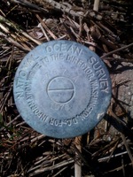
| Stamping:
|
6767 A 1978 |
| Stability:
|
Monument will probably hold position well |
| Setting:
|
A metal rod driven into ground. Describe below. |
| Description:
|
The station is located on Snake Island between the shore and first set of dunes, North of Day Marker 2,and is 10.0 m SW of the base of the dune, 5.0 m NE of the approximate highwater line. The Disk is projecting 0.6 m above ground. |
| Observed:
|
2009-11-03T16:37:00Z |
more obs 2015-11-06
|
more obs Original
|
| Source:
|
OPUS - page5 1209.04 |
|
|
|
| Close-up View
|
|
| REF_FRAME:
NAD_83(2011) |
EPOCH:
2010.0000 |
SOURCE:
NAVD88 (Computed using GEOID18) |
UNITS:
m |
SET PROFILE
|
DETAILS
|
|
| LAT:
|
32° 38' 23.48914"
|
± 0.002
m |
| LON:
|
-80° 0' 48.52339"
|
±
0.004
m |
| ELL HT:
|
-31.625 |
±
0.026
m |
| X:
|
932303.698 |
±
0.007
m |
| Y:
|
-5294640.222 |
±
0.022
m |
| Z:
|
3420376.777 |
±
0.013
m |
| ORTHO HT:
|
1.500 |
±
0.057
m |
|
|
UTM
17 |
SPC
3900(SC) |
| NORTHING:
|
3611792.408m |
89888.038m |
| EASTING:
|
592531.215m |
702160.620m |
| CONVERGENCE:
|
0.53212470°
|
0.54692676°
|
| POINT SCALE:
|
0.99970558 |
0.99995367 |
| COMBINED FACTOR:
|
0.99971054 |
0.99995864 |
|
|
|
|
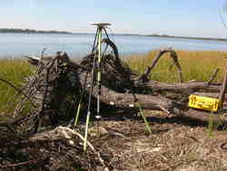
| Horizon View
|
|
|
|
|