| PID:
|
DM3223 |
| Designation:
|
866 4941 F |
| Stamping:
|
4941 F 2003 |
| Stability:
|
Monument will probably hold position well |
| Setting:
|
A metal rod driven into ground. Describe below. |
| Description:
|
Located on the Southwest end of Capers Island and along the Northside of Old Dike Road,just after the wood pier on the left and located 2.3 m Southeast from the western most piling, 1.9 m east from a mail box, 1.0 m South from the center of boardwalk. |
| Observed:
|
2009-11-02T17:39:00Z |
more obs 2009-12-01
|
more obs Original
|
| Source:
|
OPUS - page5 1209.04 |
|
|
|
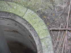
| Close-up View
|
|
| REF_FRAME:
NAD_83(2011) |
EPOCH:
2010.0000 |
SOURCE:
NAVD88 (Computed using GEOID18) |
UNITS:
m |
SET PROFILE
|
DETAILS
|
|
| LAT:
|
32° 51' 32.36721"
|
± 0.001
m |
| LON:
|
-79° 42' 26.03572"
|
±
0.002
m |
| ELL HT:
|
-32.493 |
±
0.006
m |
| X:
|
958241.055 |
±
0.003
m |
| Y:
|
-5276645.890 |
±
0.005
m |
| Z:
|
3440815.110 |
±
0.004
m |
| ORTHO HT:
|
1.044 |
±
0.037
m |
|
|
UTM
17 |
SPC
3900(SC) |
| NORTHING:
|
3636395.323m |
114502.926m |
| EASTING:
|
620960.976m |
730589.006m |
| CONVERGENCE:
|
0.70150660°
|
0.71670966°
|
| POINT SCALE:
|
0.99978041 |
0.99989288 |
| COMBINED FACTOR:
|
0.99978551 |
0.99989798 |
|
|
|
|
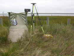
| Horizon View
|
|
|
|
|