| PID:
|
DL5745 |
| Designation:
|
872 0211 B |
| Stamping:
|
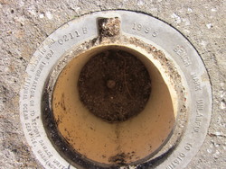
0211 B 1995 |
| Stability:
|
Monument will probably hold position well |
| Setting:
|
Stainless steel rod without sleeve (10FT+ or 3.048M+) |
| Mark Condition:
|
G |
| Description:
|
Located at the Mayport Naval Station. 149.3 ft NE of the SW end of a chain link fence line, 134.6 ft SSE of a palm tree, 23.3 ft SW of the NE end of a chain link fence line and 1.0 ft SE of a NE-SW chain link fence line and a witness post. The datum point is recessed 0.3 ft below the level of the NOS logo cap, being the top of a stainless steel rod, driven to refusal at a depth of 71.4 ft. Stamped: 0211 B 1995. |
| Observed:
|
2016-05-09T12:13:00Z |
more obs 2007-05-23
|
| Source:
|
OPUS - page5 1209.04 |
|
|
|
| Close-up View
|
|
| REF_FRAME:
NAD_83(2011) |
EPOCH:
2010.0000 |
SOURCE:
NAVD88 (Computed using GEOID18) |
UNITS:
m |
SET PROFILE
|
DETAILS
|
|
| LAT:
|
30° 23' 59.75163"
|
± 0.003
m |
| LON:
|
-81° 24' 48.14271"
|
±
0.022
m |
| ELL HT:
|
-26.236 |
±
0.047
m |
| X:
|
822060.888 |
±
0.028
m |
| Y:
|
-5444218.257 |
±
0.037
m |
| Z:
|
3208677.741 |
±
0.022
m |
| ORTHO HT:
|
2.332 |
±
0.075
m |
|
|
UTM
17 |
SPC
901(FL E) |
| NORTHING:
|
3363174.785m |
672272.180m |
| EASTING:
|
460291.796m |
160278.243m |
| CONVERGENCE:
|
-0.20918299°
|
-0.20918299°
|
| POINT SCALE:
|
0.99961945 |
0.99996063 |
| COMBINED FACTOR:
|
0.99962357 |
0.99996475 |
|
|
|
|
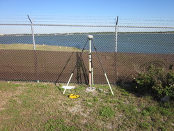
| Horizon View
|
|
|
|
|