| PID:
|
DL5744 |
| Designation:
|
872 0214 C |
| Stamping:
|
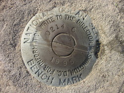
0214 C 1995 |
| Stability:
|
Monuments of questionable or unknown reliability |
| Setting:
|
Footings of small/medium structures |
| Mark Condition:
|
G |
| Description:
|
This mark is located at the Mayport Naval Air Station off Baltimore St. It is a disk set flush in the NW corner of a small concrete foundation with a high voltage transformer box number 1410 attached, south of a small red brick building number 1375, 76.2 ft north of the approximate center of a dirt road around a parking lot, 32.4 ft SE of the SW corner of building number 1375. It is a National Ocean Service Brass Disk stamped 0214 C 1995. |
| Observed:
|
2016-05-10T12:20:00Z |
more obs 2007-05-23
|
| Source:
|
OPUS - page5 1209.04 |
|
|
|
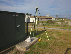
| Close-up View
|
|
| REF_FRAME:
NAD_83(2011) |
EPOCH:
2010.0000 |
SOURCE:
NAVD88 (Computed using GEOID18) |
UNITS:
m |
SET PROFILE
|
DETAILS
|
|
| LAT:
|
30° 23' 44.47889"
|
± 0.006
m |
| LON:
|
-81° 23' 43.53964"
|
±
0.013
m |
| ELL HT:
|
-25.007 |
±
0.064
m |
| X:
|
823801.765 |
±
0.018
m |
| Y:
|
-5444196.864 |
±
0.056
m |
| Z:
|
3208272.705 |
±
0.028
m |
| ORTHO HT:
|
3.582 |
±
0.091
m |
|
|
UTM
17 |
SPC
901(FL E) |
| NORTHING:
|
3362698.499m |
671795.731m |
| EASTING:
|
462013.976m |
162001.011m |
| CONVERGENCE:
|
-0.20007649°
|
-0.20007649°
|
| POINT SCALE:
|
0.99961780 |
0.99995898 |
| COMBINED FACTOR:
|
0.99962173 |
0.99996291 |
|
|
|
|
| Horizon View
|
|
|
|
|