| PID:
|
DL5344 |
| Designation:
|
872 0503 F |
| Stamping:
|
0503 F 2004 |
| Stability:
|
Monuments of questionable or unknown reliability |
| Setting:
|
Pavement (street sidewalk curb etc.) |
| Mark Condition:
|
G |
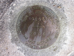
| Description:
|
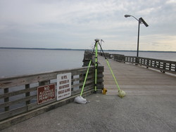
The bench mark is located at the Shands Bridge Boat Docking Facilities. It is a disk set flush in the concrete entrance to the pier, 16.9 ft NW of the approximate center line of the 20.0 ft wooden deck of the pier, 0.9 ft NW of the wooden deck of the pier and 0.2 ft south of the 7-inch concrete curb. It is a Florida Dept Of Environmental Protection Survey Mark, Stamped: 0503 F 2004. |
| Observed:
|
2016-05-17T12:21:00Z |
more obs 2014-02-24
|
| Source:
|
OPUS - page5 1209.04 |
|
|
|
| Close-up View
|
|
| REF_FRAME:
NAD_83(2011) |
EPOCH:
2010.0000 |
SOURCE:
NAVD88 (Computed using GEOID18) |
UNITS:
m |
SET PROFILE
|
DETAILS
|
|
| LAT:
|
29° 58' 50.40234"
|
± 0.002
m |
| LON:
|
-81° 38' 5.84211"
|
±
0.024
m |
| ELL HT:
|
-26.905 |
±
0.044
m |
| X:
|
804400.167 |
±
0.026
m |
| Y:
|
-5470479.801 |
±
0.038
m |
| Z:
|
3168504.155 |
±
0.021
m |
| ORTHO HT:
|
1.287 |
±
0.073
m |
|
|
UTM
17 |
SPC
901(FL E) |
| NORTHING:
|
3316812.744m |
625894.316m |
| EASTING:
|
438747.451m |
138726.544m |
| CONVERGENCE:
|
-0.31730240°
|
-0.31730240°
|
| POINT SCALE:
|
0.99964629 |
0.99998748 |
| COMBINED FACTOR:
|
0.99965051 |
0.99999171 |
|
|
|
|
| Horizon View
|
|
|
|
|