| PID:
|
DI9221 |
| Designation:
|
872 0218 A |
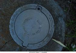
| Stamping:
|
0218 A 1995 |
| Stability:
|
Monument will probably hold position well |
| Setting:
|
Stainless steel rod without sleeve (10FT+ or 3.048M+) |
| Mark Condition:
|
G |
| Description:
|
The primary bench mark is a flange encased rod, located near the entrance to the Saint Johns Bar Pilot Association, 140.97 m (462.5 ft) north of the approximate center of Ocean Street (State Highway AIA), 66.60 m (218.5 ft) west of thecenter of the Pilot Association Dock, 66.45 m (218.0 ft) SW of the Pilot
Association Building, 37.37 m (122.6 ft) west of the NW corner of the Pilot Association Club, 19.20 m (63.0 ft) NNW of a power pole with two lights on the
top and 0.30 m (1.0 ft)SW of the NW |
| Observed:
|
2016-04-08T13:57:00Z |
more obs 2013-09-12
|
| Source:
|
OPUS - page5 1209.04 |
|
|
|
| Close-up View
|
|
| REF_FRAME:
NAD_83(2011) |
EPOCH:
2010.0000 |
SOURCE:
NAVD88 (Computed using GEOID18) |
UNITS:
m |
SET PROFILE
|
DETAILS
|
|
| LAT:
|
30° 23' 50.44281"
|
± 0.009
m |
| LON:
|
-81° 25' 39.31563"
|
±
0.018
m |
| ELL HT:
|
-27.270 |
±
0.008
m |
| X:
|
820731.677 |
±
0.016
m |
| Y:
|
-5444564.587 |
±
0.012
m |
| Z:
|
3208429.969 |
±
0.006
m |
| ORTHO HT:
|
1.282 |
±
0.051
m |
|
|
UTM
17 |
SPC
901(FL E) |
| NORTHING:
|
3362893.309m |
671990.608m |
| EASTING:
|
458925.252m |
158911.232m |
| CONVERGENCE:
|
-0.21635975°
|
-0.21635975°
|
| POINT SCALE:
|
0.99962081 |
0.99996200 |
| COMBINED FACTOR:
|
0.99962509 |
0.99996628 |
|
|
|
|
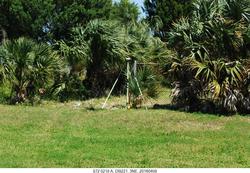
| Horizon View
|
|
|
|
|