| PID:
|
DI9220 |
| Designation:
|
872 0214 A |
| Stamping:
|
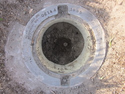
0214 A 1995 |
| Stability:
|
Monument will probably hold position well |
| Setting:
|
Stainless steel rod without sleeve (10FT+ or 3.048M+) |
| Mark Condition:
|
G |
| Description:
|
This station is located at the Mayport Naval Air Station. The bench mark is a flange-encased rod, 77.5 ft SW of the center and end of the Baltimore Street, 23.8 ft SSE of the approximate center line of Baltimore 1.8 ft NE of the SE corner of a 10.0 ft x 10.0 ft concrete pad that is around a drainage grate. The datum point is the top of a stainless steel rod, driven to refusal at a depth of 39.6 ft. It is stamped: 0214 A 1995. |
| Observed:
|
2016-05-10T12:13:00Z |
more obs 2007-05-23
|
| Source:
|
OPUS - page5 1209.04 |
|
|
|
| Close-up View
|
|
| REF_FRAME:
NAD_83(2011) |
EPOCH:
2010.0000 |
SOURCE:
NAVD88 (Computed using GEOID18) |
UNITS:
m |
SET PROFILE
|
DETAILS
|
|
| LAT:
|
30° 23' 42.44333"
|
± 0.002
m |
| LON:
|
-81° 23' 39.68511"
|
±
0.008
m |
| ELL HT:
|
-26.778 |
±
0.039
m |
| X:
|
823908.019 |
±
0.010
m |
| Y:
|
-5444211.316 |
±
0.033
m |
| Z:
|
3208217.741 |
±
0.019
m |
| ORTHO HT:
|
1.812 |
±
0.068
m |
|
|
UTM
17 |
SPC
901(FL E) |
| NORTHING:
|
3362635.481m |
671732.692m |
| EASTING:
|
462116.613m |
162103.683m |
| CONVERGENCE:
|
-0.19953137°
|
-0.19953137°
|
| POINT SCALE:
|
0.99961770 |
0.99995889 |
| COMBINED FACTOR:
|
0.99962190 |
0.99996310 |
|
|
|
|
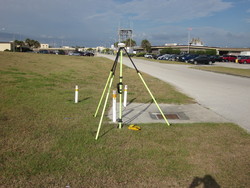
| Horizon View
|
|
|
|
|