| PID:
|
DI3378 |
| Designation:
|
853 8512 B TIDAL |
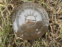
| Stamping:
|
8512 B 1977 |
| Stability:
|
Monument will probably hold position well |
| Setting:
|
Copper-clad steel rod without sleeve (10FT+ or 3.048M+) |
| Mark Condition:
|
G |
| Description:
|
The primary bench mark is a disk located near the intersection of Chestnut and Monroe Streets, 26.88 m (88.2 ft) SE of the intersection of the centerline of Monroe and Chestnut Streets, 18 m (59 ft) SW of an abandoned concrete ice house, 15.30 m (50.2 ft) north of the NW corner of house #315, and 3.54 m (11.6 ft) south of wood utility pole #6725. The bench mark is set 0.06 m (0.2 ft) below ground level, crimped to the top of a steel rod driven 6.1 m (20 ft) to refusal, and encased in PVC pipe. |
| Observed:
|
2021-11-02T11:52:00Z |
more obs 2021-11-23
|
| Source:
|
OPUS - page5 2008.25 |
|
|
|
| Close-up View
|
|
| REF_FRAME:
NAD_83(2011) |
EPOCH:
2010.0000 |
SOURCE:
NAVD88 (Computed using GEOID18) |
UNITS:
m |
SET PROFILE
|
DETAILS
|
|
| LAT:
|
39° 50' 3.45030"
|
± 0.005
m |
| LON:
|
-75° 14' 25.96733"
|
±
0.009
m |
| ELL HT:
|
-29.386 |
±
0.007
m |
| X:
|
1249475.584 |
±
0.009
m |
| Y:
|
-4742662.344 |
±
0.003
m |
| Z:
|
4063855.145 |
±
0.008
m |
| ORTHO HT:
|
3.570 |
±
0.050
m |
|
|
UTM
18 |
SPC
2900(NJ) |
| NORTHING:
|
4409393.164m |
111379.557m |
| EASTING:
|
479417.467m |
86615.302m |
| CONVERGENCE:
|
-0.15408611°
|
-0.47438611°
|
| POINT SCALE:
|
0.99960522 |
0.99994945 |
| COMBINED FACTOR:
|
0.99960983 |
0.99995406 |
|
|
|
|
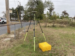
| Horizon View
|
|
|
|
|