| PID:
|
DH9545 |
| Designation:
|
872 0225 D TIDAL |
| Stamping:
|
0225 D 2004 |
| Stability:
|
May hold commonly subject to ground movement |
| Setting:
|
Set in top of concrete monument |
| Mark Condition:
|
G |
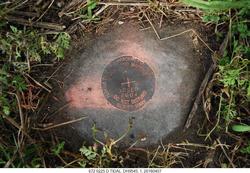
| Description:
|
The bench mark is a disk set in the top of a round concrete monument flush with
the ground about 0.2 m (0.5 ft) above the level of Denver Street,9.4 m (31.0
ft) SW of the centerline of Virginia Street, 5.9 m (19.5 ft) west of the centerline of Denver Street, 4.4 m (14.5 ft) north of wooden power pole No. 7120 80 095753, 3.4 m (11.0 ft) south of concrete power pole No. 932, 2.3 m (7.6 ft)west of the center of an iron catch basin grate, 0.6 m (2.0 ft) east of a 1.8 m(6.0 ft) high wooden fence |
| Observed:
|
2016-04-07T12:56:00Z |
more obs 2004-02-08
|
| Source:
|
OPUS - page5 1209.04 |
|
|
|
| Close-up View
|
|
| REF_FRAME:
NAD_83(2011) |
EPOCH:
2010.0000 |
SOURCE:
NAVD88 (Computed using GEOID18) |
UNITS:
m |
SET PROFILE
|
DETAILS
|
|
| LAT:
|
30° 23' 2.47014"
|
± 0.006
m |
| LON:
|
-81° 38' 19.07271"
|
±
0.018
m |
| ELL HT:
|
-25.970 |
±
0.012
m |
| X:
|
800780.450 |
±
0.017
m |
| Y:
|
-5448291.242 |
±
0.016
m |
| Z:
|
3207156.337 |
±
0.003
m |
| ORTHO HT:
|
2.322 |
±
0.055
m |
|
|
UTM
17 |
SPC
901(FL E) |
| NORTHING:
|
3361512.027m |
670608.854m |
| EASTING:
|
438643.394m |
138622.453m |
| CONVERGENCE:
|
-0.32302546°
|
-0.32302546°
|
| POINT SCALE:
|
0.99964644 |
0.99998763 |
| COMBINED FACTOR:
|
0.99965052 |
0.99999171 |
|
|
|
|
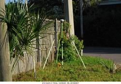
| Horizon View
|
|
|
|
|