| PID:
|
DF3658 |
| Designation:
|
946 8863 B RESET |
| Stamping:
|
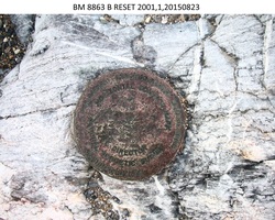
BM 8863 B RESET 2001 |
| Stability:
|
Monument will probably hold position well |
| Setting:
|
In rock outcrop or ledge |
| Description:
|
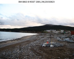
The bench mark is a disk set on a 4.1 m x 2.4 m x 0.5 m (13.4 ft x 7.9 ft x 1.6 ft) high bedrock protrusion, 123.1 m (403.9 ft) SW of bench mark 946 8863 J, 52.47 m (172.1 ft) ESE of the SE edge of a new white vinyl-sided house on the bluff running parallel to the shoreline, 29.45 m (96.6 ft) SSE of the western edge of a faded red plywood-sided house, 10.98 m (36.0 ft) SSW of bench mark 946 8863 ELI TIDAL GPS, and 0.41 m (1.3 ft) SW of the bedrock's western edge. |
| Observed:
|
2015-08-23T05:22:00Z |
more obs 2001-08-23
|
| Source:
|
OPUS - page5 1209.04 |
|
|
|
| Close-up View
|
|
| REF_FRAME:
NAD_83(2011) |
EPOCH:
2010.0000 |
SOURCE:
NAVD88 (Computed using GEOID12B) |
UNITS:
m |
SET PROFILE
|
DETAILS
|
|
| LAT:
|
64° 36' 59.19824"
|
± 0.008
m |
| LON:
|
-162° 15' 8.12008"
|
±
0.007
m |
| ELL HT:
|
9.858 |
±
0.009
m |
| X:
|
-2611176.759 |
±
0.007
m |
| Y:
|
-835730.944 |
±
0.005
m |
| Z:
|
5739516.926 |
±
0.010
m |
| ORTHO HT:
|
3.567 |
±
0.016
m |
|
|
UTM
3 |
SPC
5007(AK 7) |
| NORTHING:
|
7168556.432m |
1182566.273m |
| EASTING:
|
631397.562m |
487930.578m |
| CONVERGENCE:
|
2.48282363°
|
-0.22790268°
|
| POINT SCALE:
|
0.99981140 |
0.99990178 |
| COMBINED FACTOR:
|
0.99980986 |
0.99990024 |
|
|
|
|
| Horizon View
|
|
|
|
|