| PID:
|
DD2905 |
| Designation:
|
022 024 AZ MK |
| Stamping:
|
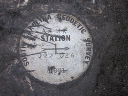
AZ MK 022 024 1981 |
| Stability:
|
May hold commonly subject to ground movement |
| Setting:
|
Set in top of concrete monument |
| Mark Condition:
|
G |
| Description:
|
The bench mark is a disk set in a concrete monument located near a power pole at the entrance to the Tom Yawkey Wildlife Center. 54.7 ft WNW of the center of the monument to the Tom Yawkey Wildlife Center, 19 ft SSW of the centerline of the road leading to the main gates of the Wildlife Center, 4.4 ft NE of a Power Pole, 2.8 ft NE of a Verizon box# L324 P112, 4.0 ft N of a Caution Telephone Cable Underground sign. It is a South Carolina Geodetic Survey Disk stamped: 022 024 AZ MK 1981. |
| Observed:
|
2016-02-02T13:49:00Z |
more obs 1993-09-20
|
| Source:
|
OPUS - page5 1209.04 |
|
|
|
| Close-up View
|
|
| REF_FRAME:
NAD_83(2011) |
EPOCH:
2010.0000 |
SOURCE:
NAVD88 (Computed using GEOID18) |
UNITS:
m |
SET PROFILE
|
DETAILS
|
|
| LAT:
|
33° 13' 43.59447"
|
± 0.004
m |
| LON:
|
-79° 12' 17.89435"
|
±
0.008
m |
| ELL HT:
|
-33.989 |
±
0.003
m |
| X:
|
1000270.705 |
±
0.008
m |
| Y:
|
-5246075.263 |
±
0.002
m |
| Z:
|
3475191.766 |
±
0.005
m |
| ORTHO HT:
|
0.615 |
±
0.055
m |
|
|
UTM
17 |
SPC
3900(SC) |
| NORTHING:
|
3678085.608m |
156204.120m |
| EASTING:
|
667261.085m |
776878.974m |
| CONVERGENCE:
|
0.98387473°
|
0.99516310°
|
| POINT SCALE:
|
0.99994494 |
0.99982303 |
| COMBINED FACTOR:
|
0.99995028 |
0.99982837 |
|
|
|
|
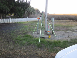
| Horizon View
|
|
|
|
|