| PID:
|
DD1710 |
| Designation:
|
866 0265 B TIDAL |
| Stamping:
|
0265 B 1976 |
| Stability:
|
Monument will probably hold position well |
| Setting:
|
Copper-clad steel rod without sleeve (10FT+ or 3.048M+) |
| Mark Condition:
|
G |
| Description:
|
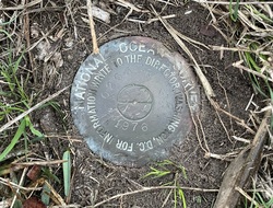
The bench mark is at the intersection of Lake Dr and 36th Ave North in the NW quadrant. 31.2 ft WSW of the center line of 36th Ave, 27.6 ft SE of the SE corner of the house at 3809 Lake Dr, 6 inches SSW of a witness post, and 5.9 ft SW of utility pole #37721 C121 with 2 guy cables. The bench mark is set at ground level, crimped to a copper-clad steel rod driven 24 ft to refusal, and encased in a 4-inch PVC pipe and concrete kickblock. It is a National Ocean Service Disk Stamped 0265 B 1976. |
| Observed:
|
2023-01-13T18:35:00Z |
more obs 2023-01-30
|
| Source:
|
OPUS - page5 2008.25 |
|
|
|
| Close-up View
|
|
| REF_FRAME:
NAD_83(2011) |
EPOCH:
2010.0000 |
SOURCE:
NAVD88 (Computed using GEOID18) |
UNITS:
m |
SET PROFILE
|
DETAILS
|
|
| LAT:
|
33° 49' 56.55029"
|
± 0.006
m |
| LON:
|
-78° 37' 49.40864"
|
±
0.011
m |
| ELL HT:
|
-33.104 |
±
0.038
m |
| X:
|
1045538.711 |
±
0.013
m |
| Y:
|
-5199526.814 |
±
0.033
m |
| Z:
|
3530998.565 |
±
0.017
m |
| ORTHO HT:
|
2.058 |
±
0.069
m |
|
|
UTM
17 |
SPC
3900(SC) |
| NORTHING:
|
3746095.804m |
224199.586m |
| EASTING:
|
719281.068m |
828881.269m |
| CONVERGENCE:
|
1.31984167°
|
1.31370833°
|
| POINT SCALE:
|
1.00019281 |
0.99979769 |
| COMBINED FACTOR:
|
1.00019801 |
0.99980289 |
|
|
|
|
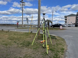
| Horizon View
|
|
|
|
|