| PID:
|
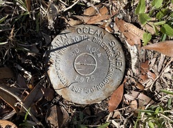
DD1470 |
| Designation:
|
866 1559 TIDAL SD 4 |
| Stamping:
|
S.D. NO. 4 1975 |
| Stability:
|
Monument will probably hold position well |
| Setting:
|
Copper-clad steel rod without sleeve (10FT+ or 3.048M+) |
| Mark Condition:
|
G |
| Description:
|
The BM is a disk located near the north corner of the intersection of US Highway 17 Business and Vauxhall Ave, 37m (120ft) NNW of Bench Mark SD NO 3 1975, 15.76m (51.7ft) NW of the centerline of US Highway 17 Business, 7m (23ft) NE of Vauxhall Ave, 2.01m (6.6ft) south of a large pine tree, and 1.07m (3.5ft) SE of utility pole #U1A.
The bench mark is level with the ground, crimped to the top of a copper-clad steel rod driven 14.0m (46ft) to refusal, encased in PVC pipe and a concrete kickblock. |
| Observed:
|
2023-02-07T13:18:00Z |
more obs 2023-02-27
|
| Source:
|
OPUS - page5 2008.25 |
|
|
|
| Close-up View
|
|
| REF_FRAME:
NAD_83(2011) |
EPOCH:
2010.0000 |
SOURCE:
NAVD88 (Computed using GEOID18) |
UNITS:
m |
SET PROFILE
|
DETAILS
|
|
| LAT:
|
33° 33' 3.94531"
|
± 0.009
m |
| LON:
|
-79° 2' 30.40926"
|
±
0.009
m |
| ELL HT:
|
-32.358 |
±
0.026
m |
| X:
|
1011468.960 |
±
0.007
m |
| Y:
|
-5223891.348 |
±
0.020
m |
| Z:
|
3505040.844 |
±
0.018
m |
| ORTHO HT:
|
2.456 |
±
0.059
m |
|
|
UTM
17 |
SPC
3900(SC) |
| NORTHING:
|
3714101.598m |
192215.876m |
| EASTING:
|
681796.913m |
791407.755m |
| CONVERGENCE:
|
1.08256667°
|
1.08563611°
|
| POINT SCALE:
|
1.00000747 |
0.99979578 |
| COMBINED FACTOR:
|
1.00001255 |
0.99980086 |
|
|
|
|
| Horizon View
|
|
|
|
|